A brief archival entry or reference document containing only an archive reference number (MS 09707/4/37-38) and what appears to be an internal cataloging code (AP 42C). The document provides insufficient content for detailed analysis.
This small broken slab was found at the possible site of a keeill (IOMHER 0567.00) near the Dhoon. The slab shows the remains of a simple 'Celtic' cross with an extended lower limb, set on a broad ring.
A broken slab with a shafted Celtic ring cross. It was found at the site of a keeill on Cooillean Ard (PRN 0567.00) in 1894 and is kept in Maughold Cross House (Manx Cross No. 56). The slab measures 75.5 centimetres high x 55.5 centimetres maximum width and 5 centimetres thick.
The findspot of a broken slab inscribed with a shafted and ringed Celtic cross, found here in 1894. It measures 84 centimetres x 53.3 centimetres x 5 centimetres and is kept at the Maughold Cross House.
The reputed site of an early medieval keeill or chapel which would have been in use during the period circa AD500 to AD1000. It is thought to have been located on intack lands on the eastern slope of Slieau Ruy, at a height of about 240 metres, but no trace of it remains. In 1894, a 7th or 8th century cross-slab (Manx Cross No. 32) was found here. It is now kept in the collection of crosses at the Parish Church.
Medieval shieling.
The place name Ardarry (historical forms include Arderry and Ardary, modern forms include Ardairey and Ardery) relates to one of the primary land divisions known as 'treens'. Additionally, one of the four constituent quaterland farms within the treen also bore the name historically. The quarterland was latterly centred on a farmstead named Ballastroke, although the names Ardery and Ardairey is still closely associated. The grid reference is centred on Ballastroke. The Ordnance Survey of 1868 placed 'Ardairey' at SC2467570920, though this farm is now named Ballacurphey: it lies in the neighbouring treen of Ballafadda.
The name appears to derive from 'Ard-eary' meaning 'high shieling', relating to the practice of seasonal transhumance, or the moving of stock from lowland farmland to upland grazing during the summer months. There is extensive physical and place name evidence for the former practice on the Isle of Man.
Although there is no clear evidence for the sites of shielings on Ardairey, it is noteworthy that the treen shares the place name element '-eary' with two more of the nine treens which make up the parish of Arbory.
An oval cairn near the boundary line between Braddan and Onchan parishes. It is orientated northeast to southwest, measuring 21.0 metres by 10.0 metres with an average height of 0.5 metres. It is grass and fern covered with a considerable amount of fairly large stones exposed. The cairn is crossed by a wall at the southeast side beyond which there is no trace of its mound.
In the middle of the mound 3.0 metres from the northwest edge is a cist orientated northwest to southeast, lined on all sides but the northwest with stone slabs, with the southeast stone now falling inwards. The cist measures 1.6 metres lonmg and is 0.5 metres deep. The capstone has been moved to the side and measures 1.4 metres by 1.0 metres and is 0.2 metres thick.
Axeheads have been found here and a limited excavation was carried out on the cairn by A.M. Cubbon in 1975.
This is page 25 of a legal opinion or petition concerning the rights of ecclesiastical officers to sit in the Manx House of Keys Council. The document argues that since the revestment (returning sovereignty to the Athol family) and church patronage being reserved to them, ecclesiastics have no constitutional basis to claim Council membership. It notes a 26-year gap (1765-1791) without such claims, and criticises recent admissions of clergy and new officers like an 'Acting Attorney-General' as unconstitutional innovations.
A legal argument asserting the rights and powers of the Lords proprietors of the Isle of Man under a Parliamentary Charter. The document enumerates the successive exercise of sovereign powers including appointment of officials, judiciary, coinage, and revenue collection, claiming these establish an incontestable title through use, inheritance, and historical record.
A legal argument discussing whether a statute (7th of George the First) concerning customs seizures was ever actually executed in the Isle of Man. The author argues the Act was ineffectual and never enforced, making it a 'dead Letter' that had no effect on the Lord's rights or property. The fragment discusses acquiescence and statutory authority.
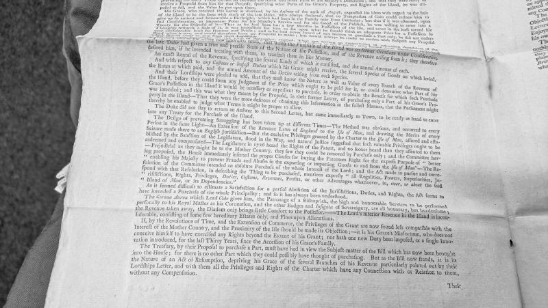
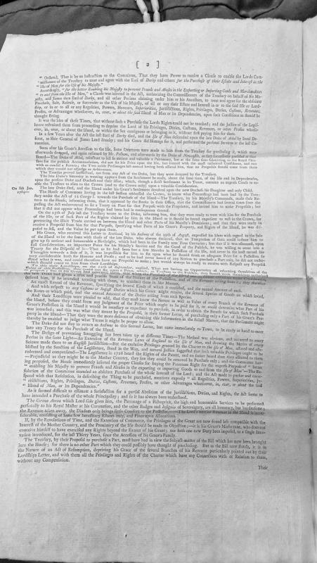
This is a legal memorandum or opinion addressing negotiations between the Duke of Atholl and the British Treasury regarding the potential purchase of the Isle of Man. It discusses the historical context of smuggling prevention efforts, the exclusive privileges granted by charter, and argues that a proposed bill constitutes an act of resumption depriving the Duke of revenue branches without compensation.
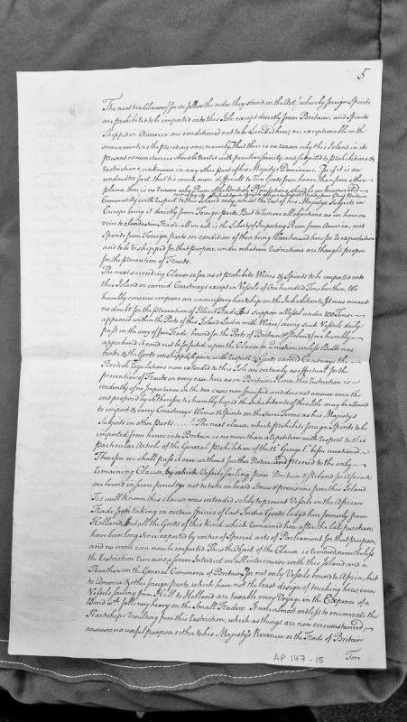
A detailed legal/commercial argument petitioning for relief from trade restrictions imposed on the Isle of Man, including prohibitions on importing foreign spirits, restrictions on vessel size for wine and spirit imports, and penalties on vessels taking provisions for Africa. The document argues these restrictions are unnecessarily severe and serve no useful purpose given changed circumstances.
This document presents arguments concerning the Crown's proposed purchase of the Isle of Man from its proprietor, the Duke of Athol. It outlines the historical legal basis for such a purchase under an Act of George I, chronicles negotiation attempts between the Treasury and the Duke, and argues that proposed legislation amounts to an unlawful act of resumption rather than a fair purchase, depriving the Duke of revenue and privileges without compensation.
This large monument was found in the churchyard during the 1880s.
Each face bears a shafted cross without circle, the space to either side of which has been decorated with groups of animals.
On one face, the cross shaft is decorated with a plait-of-five, and edged with narrow borders of step-pattern and key-fret. Above the head is a horizontal band of plait-of-four, and the shaft rests on another bordered band decorated with twist-and-ring. Above each arm is the figure of a bird or cockerel, symbols of the resurrection in Christian tradition. To the left, the slab is decorated from the bottom with the figures of an ox, a boar, a mounted hunter with a short spear or club, and a hound pursuing a stag. On the right a goat is followed by a wolf, a hind and a bear, while a hound runs in the opposite direction.
The other face also bears a cross, the shaft of which is decorated with a ring-chain pattern terminating in a small cross. Above the head are two linked triquetras. Two birds again stand above the arms of the cross. The left panel depicts from the top a stag, a coiled snake, and four more animals which have been identified as a wolf, a bear, a second wolf, and a dog. To the right are a goat, a ram, a snake, the damaged remains of what is possibly an ox, and a boar.
Below the cross is a robed figure on horseback, one hand on the reins, the harness clearly shown in front and behind the rider. Both legs are visible, suggesting that the figure is riding 'aside' because of their flowing clothes. At the foot of the stone, as though added after the rest of the cross had been carved, is an incised figure of a wolf's head and forequarters.
A runic inscription is written from bottom to top of one edge and translates, 'Sandulf the black erected this cross in memory of Arinbiaurk his wife'.
It would appear that the horsewoman is Arinbjork herself, and that the figure of the wolf is a play on the name of the man - Sand-wolf - responsible for commissioning the memorial.
The site of a Bronze Age round barrow. It is a turf covered mound which shows a high stone content. It has a diameter of 9.0 metres and an average height of 0.6 metres. There are traces of burning which may be due to comparatively recent farming activities. It has a retaining circle or kerb of granite boulders average 0.5 metres high, 1.0 metre wide by 0.3 metres thick. Some small stones have evidently been dumped on top from field clearance.
Bronze Age burial mound.
The site has not been excavated, but appears to consist of a burial mound on which are set a ring of large quartz boulders. The monument is classically and prominently located on a ridge rising from Arragon Mooar and extending north-east towards Santon Church.
The mound is about 14m in diameter, and is more than a metre high. The ring of stones is about 6m across, and the area within is slightly sunken as if collapsed, robbed out or eroded.
The site of a 19th century horse engine. The roofed 'horse-walk' which housed the machinery for the horse-powered threshing-mill survived into modern times.
Letter from Arthur Onslow, Collector of Customs at Liverpool, responding to official inquiry about the Isle of Man smuggling trade and foreign goods imports. Onslow provides accounts of duties payable to the Proprietor, analysis of the book of rates (dating to 1692), and strategic observations on declining trade and the role of the East India Company and African merchants. Directly relevant to understanding commercial conditions preceding the 1765 Revestment.