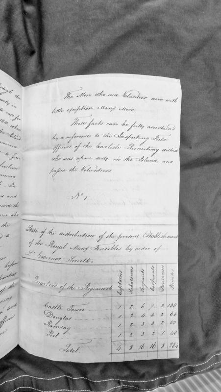
Administrative document detailing the organizational structure and deployment of the Royal Manx Fencibles regiment across four quarters of the Isle of Man. Provides a comprehensive breakdown of personnel by rank and garrison location, showing a total establishment of 4 captains, 8 subalterns, 16 sergeants, 16 corporals, 8 drummers, and 284 privates.
A post-medieval lead mine in Patrick parish. Dixon's Mine, in the Foxdale/Glen Rushen mining field, produced lead and zinc and operated from about 1835 to 1868, though few significant surface remains survive today (recorded location SC267780). A historical plan held by Manx National Heritage shows the old engine shaft, flue, chimney and associated lean-to structures.
A post medieval lead mine in Patrick parish. The mine worked a vein known as Dixon's Vein in the Foxdale area: a shaft had been sunk to seven fathoms by 1836, but flooding forced a suspension of work until an adit was driven to drain the mine to the twenty-fathom level by May 1837. Levels were then driven east and west at the seven- and seventeen-fathom horizons, with ore removed by rail, before operations were again suspended in 1842 and surface trials were cut to trace the veins.
The Ordnance Survey 1:2500 large-scale mapping published in 1869 shows a small enclosure at the grid reference provided, which served as a small post-medieval stackyard adjacent to a roofed building.
The enclosure and building have been cleared and incorporated into a field serving as permanent pasture.
The site of a farmstead and associated features. The house measures circa 7 metres long by 3 metres wide. The house was excavated in 1969. This was a longhouse with turf walls with some facing stones, benches and a central hearth. Associated with it was a rectangular corn-drying kiln and traces of a boundary wall.
The only finds were a spindle whorl, a fragment of an iron buckle (unstratified) and a sherd of dark grey unglazed pottery. Three flints were also found, thought to have probably come from turves used in walls or roofing of house. A medieval date seems likely and it would appear to be the home of a Norse crofter
Unworked flint nodules 'from cairn near doalish cashen.' The site may be a cairn recorded in the HER as PRN 0994.00 or a mound recorded as PRN 1001.00.
A shapeless, grass-covered mound, measuring 12.0 metres across and up to 0.6 metres high. A crude excavation hollow on the top shows a considerable stone content in the mound. It is not thought to be a barrow.
A shapeless, grass-covered mound, measuring 12.0 metres across and up to 0.6 metres high. A crude excavation hollow on the top shows a considerable stone content in the mound. It is not thought to be a barrow and may well be a shieling mound.
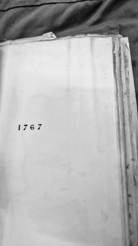
A historical document from the Isle of Man dated to the year 1767. Limited textual content is visible in the transcription, providing minimal information about the document's specific purpose or subject matter.
A comprehensive collection of primary documents relating to Rev. William Smith's 1758 petition to the King in Council against his imprisonment by the Pennsylvania Assembly. Includes Smith's petition (dated 6 February 1758), Benjamin Franklin's detailed notes refuting the petition point-by-point, observations on attacks on the Quakers, and procedural notes for counsel. These documents were presented at hearings before the Attorney General and Solicitor General on 20 and 27 April 1758, and provide crucial evidence of early American colonial constitutional disputes and Assembly claims to parliamentary privilege.
The findspot of a Mesolithic flint scatter which included a ground and pressure-flaked adze, much worn by use, measuring 63 millimetres x 35 millimetres x 13 millimetres . A Heavy-blade or Bann type missile point and an irregular blade showing secondary working were also found.
The findspot of an early prehistoric flint scatter consisting of 17 chips and cores.
A flat slate slab with a pair of opposing circular holes in its faces was also found in a haphazard arrangement of slabs and boulders near the top of the cliffs.
District near Dublin associated with the Irish property and family connections of the Manx merchant George Moore.
George Moore of Peel married Catherine Callan, the daughter of a Dublin merchant, in 1733. His surviving letter books show that his commercial and family interests extended well beyond the Isle of Man.
An account of Moore's career records that he held substantial interests in Ireland, including an estate at Donnybrook. These interests took him to Ireland annually. The same account contrasts this with his developing Manx business: by 1750 he had been established at Peel for many years and had ceased to take part in the older Moore family concern at Douglas.
The Donnybrook property therefore appears in the surviving evidence as part of the wider network maintained by a Manx merchant whose trade, property and family relationships crossed the Irish Sea.
The present evidence pack contains only one direct Donnybrook reference, and it does not provide details of the estate's size, exact location or later ownership.
Doran's Bend is named for Grand Prix racer Bill Doran, who broke his leg crashing his AJS on the left-hand bend after Ballig Bridge during a Thursday-evening practice session. Sources differ slightly on the year: Doran's own racing biography places the crash in 1952 practice for the Isle of Man TT, while a separate course-corner listing gives 1950; either way, the bend has carried his name ever since. Doran went on to finish runner-up to Geoff Duke in the 1951 350cc world championship before a later crash at Rouen ended his career in 1953.
Dorothy Pantin (28 June 1896 - 6 August 1985) was born in Douglas and became the Isle of Man's first woman medical doctor and surgeon, qualifying via the London School of Medicine in 1922 and returning to the Island in 1923. As honorary surgeon at Noble's Hospital from 1926, she performed the Island's first blood transfusion that year and its third (and second successful) Caesarean section in 1928, and oversaw the design of a new maternity building opened in 1939; during her career maternal mortality rates on the Island fell by more than half. She served as president of the Isle of Man's British Medical Association branch in 1937 and is commemorated with a plaque at Noble's Hospital and an Isle of Man postage stamp.
Doug Fargher (1926-1987), also known by the Manx name Doolish y Karagher, was a Manx language activist, author and radio personality central to the language's mid-20th-century revival. As a young man in the 1940s and 50s he cycled around the Island with fellow enthusiasts Walter Clarke and Leslie Quirk to learn from surviving elderly native Manx speakers, and he went on to compile the English-Manx Dictionary (1979), the first modern dictionary of the language.
Capital and largest town of the Isle of Man, on the east coast at the mouth of the rivers Dhoo and Glass.
The Manx form Doolish was explained by an early dictionary as referring to the meeting of the two rivers, one described as black and the other as green or white, their junction producing a dark green colour. The rivers meet immediately above the harbour and provided the anchorage around which the old town developed.
Douglas was still a relatively small settlement in the early eighteenth century, but its harbour and position on the east coast encouraged rapid commercial growth. George Moore, the Peel merchant, began acquiring property there in the 1750s. In 1751 he complained that houses and cellars were difficult to obtain because the town was crowded with people coming in from elsewhere and almost every available space was occupied.
The harbour became increasingly important as trade expanded. By the end of the eighteenth century harbour duties, together with the herring custom and bay fisheries, formed a substantial part of the revenue available for the maintenance of the Island's ports. The harbour fund for the year ending July 1791 produced £319 5s. 1½d. in harbour duties and £95 19s. 3½d. from the herring custom and bay fisheries, although £327 was spent on repairs.
Douglas gradually displaced Castletown as the Island's principal commercial centre. The growth of the town brought new churches, streets, quays and public buildings, and the settlement spread beyond the older harbour-side streets into Braddan and Onchan. The old river crossings and the harbour continued to determine the shape of the centre.
Municipal growth produced increasingly expensive public works. In 1929 the House of Keys was reminded that Douglas Corporation, while still a Board of Commissioners, had paid £140,000 for the Douglas Waterworks Company and subsequently spent between £180,000 and £190,000 developing the undertaking.
By the twentieth century the House of Keys and Tynwald were also meeting in Douglas, although the Island's older administrative centre remained at Castletown for much of the nineteenth century.
The stables on Tramway Terrace, at the northern end of Queen's Promenade, originate from 1877 when Thomas Lightfoot, the tramway's founder, bought a small property with a rear yard here near the original terminus of what would become the Douglas Bay Horse Tramway. He built a larger stables to the rear and a terrace of three plain, cement-rendered houses facing the road; the resulting "Lower Stables" could house up to 33 tram horses once a lean-to extension was added in the 1880s. In 1911-12 Douglas Corporation redeveloped the associated Upper Stables site, converting old shops into rentable premises with saddlers' workshops above and moving the blacksmithing operation into a rear lean-to. The tramway itself, begun in 1876, is the longest continuously operating horse tramway in Britain, having run every year except during the Second World War.
Roman coin.
A 2nd century Roman coin was reportedly found on Douglas beach prior to 1953, when noted by Ordnance Survey staff.
The coin was reportedly of the reign of Antoninus (AD138-161). No further information is known and the coin is not in the Manx National Heritage collections. The grid reference is placed at the central point of the bay but is for indicative purposes only.