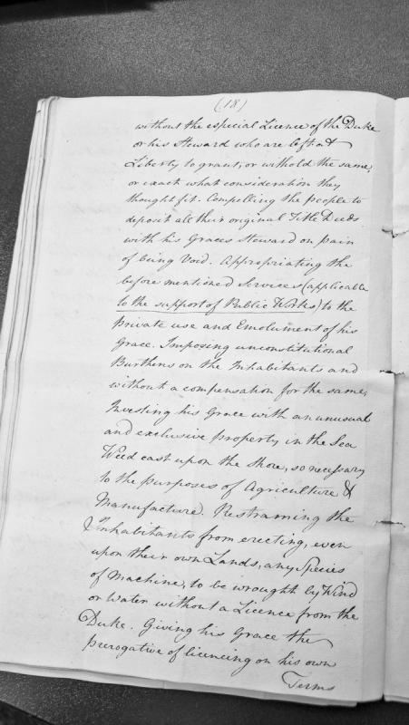
A formal petition or legal document detailing grievances against the Duke's exercise of authority over the inhabitants. It complains of arbitrary licensing requirements, confiscation of title deeds, appropriation of public services for private use, restrictions on manufacturing, and exclusive claims to sea resources.
This fragment of a cross slab was found in the churchyard wall in the 1800s. It is kept at Kirk Michael church.
Both faces show the head of a wheel-headed cross, decorated with looped bands gripped by rings. The arms of the cross are linked by a plain bordered ring. One face shows a cockerel, a symbol of the Resurrection, and a winged figure, perhaps an angel, above the left and right arms respectively. A figure in the centre of the cross possibly represents Christ in ascension, with a 'nimbus' or halo above his head and his arms outstretched in blessing. The other face shows a serpent above the left arm of the cross and a male figure and a bird above the right.
Along one edge the latter part of an inscription in runes survives, which has been translated as, '...of Grim the Black'.
See also Manx Cross 129.
These two fragments were found built into the wall of the old church. On each face they bear the shaft of a cross and the lower part of a plain ring connecting the limbs. One side only shows interlaces, namely, double-twist and diamond-shaped rings, plain twist-and-ring, and a decorated form of tendril pattern.
The other face bears a ring-chain pattern on the shaft, and the panels to either side are occupied with figures. To the left is a robed man crowned by a 'nimbus' or halo and carrying a staff. Below him are two armed men, one of whom is upside down, and a boar. To the right are two hounds or wolves, followed by a man armed with a sword and spear, and below him a monster, perhaps a giant fish.
The edge bears a damaged inscription which has been translated as, 'Grim raised this cross to the memory of Hromund (his brother's) son.'
This fragment of a cross slab was found in the churchyard wall in the 1800s. Both faces show the head of a wheel-headed cross, decorated with looped bands gripped by rings. The arms of the cross are linked by a plain bordered ring.
One face shows a cockerel, a symbol of the Resurrection, and a winged figure, perhaps an angel, above the left and right arms respectively. A figure in the centre of the cross possibly represents Christ in ascension, with a 'nimbus' or halo above his head and his arms outstretched in blessing. The other face shows a serpent above the left arm of the cross and a male figure and a bird above the right.
Along one edge the latter part of an inscription in runes survives, which has been translated as, '...of Grim the Black'.
Two fragments of a carved cross-shaft which were found built into the wall of the old church of Kirk Michael.
On each face they bear the shaft of a cross and the lower part of a plain ring connecting the limbs. One side only shows interlaces, namely, double-twist and diamond-shaped rings, plain twist-and-ring, and a decorated form of tendril pattern. The other face bears a ring-chain pattern on the shaft, and the panels to either side are occupied with figures. To the left is a robed man crowned by a 'nimbus' or halo and carrying a staff. Below him are two armed men, one of whom is upside down, and a boar. To the right are two hounds or wolves, followed by a man armed with a sword and spear, and below him a monster, perhaps a giant fish.
The edge bears a damaged inscription which has been translated as, 'Grim raised this cross to the memory of Hromund (his brother's) son.'
See also Manx Cross 126.
The site of a post-medieval corn mill. Groudle Glen was developed as a Victorian tourist attraction in the 1890s, with a miniature railway, bandstand, and zoo; a mill, crofters' cottages and a bridge accessing the Howstrake Holiday Camp are recorded at the beach, though no date, owner, or operational history for the mill itself was found.
The Groudle Glen Hotel was built by R.M. Broadbent, the farmer who owned Bibaloe Beg Farm and who saw an opportunity when an electric tramway was planned along Banks Howe to link Douglas with a proposed satellite town. Broadbent developed the wooded valley below his farm as the 'Fern Glen of the Isle of Man', planting the trees still seen today and creating a sea-lion pool at the cove, and the hotel opened for business in September 1893 to coincide with the new electric railway's arrival. Over the winter of 1895-96 he went on to lay the track for the narrow-gauge Groudle Glen Railway, which still runs past the hotel today. It is registered as a former public house.
A 2ft-gauge miniature railway built in 1896 by entrepreneur Richard Broadbent to carry Victorian tourists from Groudle Glen down to a small headland zoo that once kept sea lions and polar bears. It closed in 1962, but volunteers began restoring it in 1982 and reopened it in 1986; the original 1896 locomotive Sea Lion still runs on the line, now operated as a charity on summer Sundays.
Modern watermill.
The Ordnance Survey 1:2500 First Edition mapping of 1867 depicts a watermill complex at this location, annotated as 'Groudle Mill (Corn)'.
The grid reference relates to the former site of the mill.
The complex has been demolished and the site redeveloped for tourist purposes.
Modern watermill.
The Ordnance Survey 1:2500 First Edition mapping of 1867 depicts a watermill complex at this location, annotated as 'Groudle Mill (Corn)'.
The use of the site for milling may date back to at least the beginning of the 16th century, as the Manorial Roll (1511) records a mill at Cawdall (Groudle).
The grid reference relates to the former site of the mill.
The complex has been demolished and the site redeveloped for tourist purposes.
Modern mill leat.
The Ordnance Survey 1:2500 First Edition mapping of 1867 depicts a watermill complex at this location, annotated as 'Groudle Mill (Corn)'.
A leat, protected by a sluice, leads water off from the Groudle River for a distance of 190m to the mill. An overflow channel protects the mill 100m upstream. The channel is still visible at this point. The grid reference refers to this location, approximately halfway along the leat.
The complex has been demolished and the site redeveloped for tourist purposes.
Groudle Viaduct, built in 1894, is an unusual structure that carries both road and rail traffic near King Edward Road in Onchan, part of the infrastructure built alongside the Manx Electric Railway's early extension along the coast toward Groudle and Laxey. It was one of thirteen historic structures given protected status together on 2 September 2025 in recognition of Manx heritage spanning over 800 years.
The Grove Museum of Victorian Life, on Andreas Road near Ramsey, preserves the house and gardens of Poplar Grove, bought in 1838 by Liverpool shipping merchant Duncan Gibb as a summer retreat and later transformed into a country residence with extensive grounds. After retiring from shipping in 1862 Gibb lived there as a gentleman farmer until 1867; his granddaughters Alice and Janet moved in in 1887 and remained for almost a century, keeping the house largely unchanged since its Victorian heyday. Manx National Heritage acquired the property in 1976 and preserves it as, in its own description, the island's most authentic Victorian house and gardens. The site also has working farm elements, including a horse-drawn threshing mill, and keeps heritage Loaghtan sheep.
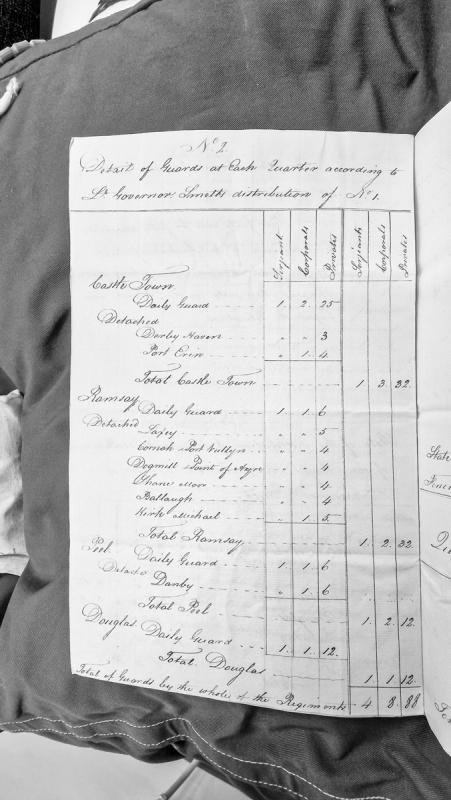
A tabular administrative document showing the distribution of military guards across four main garrison towns on the Isle of Man: Castle Town, Ramsey, Peel, and Douglas. The table details daily guards and detached positions at various strategic locations, with numerical allocations appearing to represent personnel counts.
This Guard House and Fire Party building belonged to RAF Jurby, which opened on about 400 acres in September 1939 and trained bomber crews as No. 5 Air Observers School, later No. 5 Bombing and Gunnery School, before also basing Polish, Czechoslovak and Australian fighter squadrons between late 1940 and late 1941. No historical detail specific to this individual guard house and fire party building beyond its registration and the station's general wartime role could be verified online.
Channel Island which appears in Manx constitutional and administrative sources as a frequent comparator for the Isle of Man.
When the Duke of Atholl discussed proposals for the Crown to acquire Mann in the eighteenth century, he argued that transfer of the lordship would not remove the Island's separate laws and internal government. In a memorandum copied in 1759 he compared Mann directly with “Guernsey Jersey Sark and Alderney”, where imports and exports were governed by their own laws despite their allegiance to the same Crown.
Guernsey and Mann also appear together in Commonwealth administrative records. After the Civil Wars, the Council of State dealt separately with the surrender, garrisoning and government of several island jurisdictions. A 1655 list of English and island garrisons included Guernsey, Jersey and the Isle of Man among the places whose military establishments were being reviewed.
The comparison was therefore practical as well as constitutional: all were island jurisdictions under the English Crown whose local government, defence and customs arrangements required separate administrative treatment.
The site of a Bronze Age barrow. Nothing is shown here on the 1870 1:2500 Ordnance Survey map. P.M.C. Kermode's 1930 List of Manx Antiquities records the mound, by then already levelled, a quarter of a mile north-east of the house (OS reference II/16).
The site of a Bronze Age barrow shown as a 'Tumulus' in the field numbered Plot 1541 on the 1870 1:2500 Ordnance Survey map. It has been levelled by past ploughing activity. Only some large stones exposed on the surface remained when the site was recorded in 1930. In modern times it was only vaguely discernible but no suface stones remained and it had been virtually destroyed as a surface feature.
S-bend formerly "The Cutting," parish of Lezayre. Cairn built 1939 by public subscription at the point where Jimmie Guthrie retired from his final TT (1937 Senior); he died later that year at the German Grand Prix.