Henry VII (1457-1509), first of the Tudor kings, whose accession settled the Stanleys in the lordship of Mann.
The Manx account of it is brief and pointed: it was for Richard III's attempts on Thomas, Earl of Derby, and on his son the Lord Strange that Henry VII, whose mother Thomas had married, got his crown so early.
The family's affairs in the Island are dated by his regnal years thereafter. George, third son of Thomas, Earl of Derby, died in the thirteenth year of Henry VII at Derby House on St Bernard's Hill in London, the building that afterwards became the College of Arms. The terms on which the Island had earlier been granted to Scrope, and the limits set on his heirs, were still being recited in the Manx records of the reign.
Henry VIII (1491-1547), King of England, who took the lands of Rushen Abbey.
The Manx antiquaries make a point of what the English Crown had and had not been granted. When the Island passed to the kings of England no rights of Holy Mother Church were made over with it, and yet, as one editor observes, they afterwards presumed to give or to sell the patronage of the bishopric, and Henry VIII and Elizabeth seized on the lands and revenues of Rushen Abbey.
The lordship itself stayed with the Stanleys through his reign, and the Island felt the Reformation as the dissolution of its abbey rather than as a change of lord.
The Herring Tower stands on the Langness peninsula about 2km southeast of Castletown, built in 1811 by the architect Thomas Brine, who modelled it on the tower of Peel Castle. Brine had been commissioned by the British Government to build two such daymarks on the Island to help cargo ships navigate the coast safely, the other being an identical tower on Douglas Head, now part of the Douglas Head Hotel. During the herring season a fire was lit in the tower to guide fishing boats safely into Derbyhaven, though it failed to prevent numerous wrecks (forty were recorded after its construction), which eventually led to the building of Langness Lighthouse, first lit in December 1880. The Herring Tower has been a registered building since 1991.
A Bronze Age barrow excavated by Cubbon in 1932. A Neolithic Ronaldsway roughened-butt axehead, polished 4 inch by 2.5 inch found during the excavation, which may well have been in the field from which the material for the mound was obtained. It was found about 21 feet from the summit of the barrow, to the south side.
An artificially-fashioned 'sling stone' was also found on the spot and a few stones which had suffered burning. The mound appeared to be sepulchral and only the original covering had been disturbed.
During W. Cubbon's excavation of a probable Bronze Age barrow in 1932, some burnt stones were reported near the barrow, which are thought to perhaps represent the site of a Bronze Age burnt mound.
Highbury House stands at 3 Parliament Square in the heart of old Castletown, beside the site of the former Old House of Keys. Beyond its listing alongside 'Keys Cottage' in local historical notes, no further verifiable detail on its construction date or history could be confirmed from available sources.
The site of a post-medieval sundial at Highton, which was a solitary dwelling outside Douglas at the time of the 1870 1:2500 scale Ordnance Survey map.
Above this inscription there are the letters "VE" and "VJ" inscribed either side. This, as well as the years, are in gold lettering. Obelisk made of stones with slate plaque mounted on the front. Information provided by the Isle of Man Government Preservation of War Memorials Committee. Image courtesy of Chris Blyth, Isle of Man Photographic Society. Find on Map or Report Condition
Bronze Age burial mounds.
The Ordnance Survey 1:2500 First Edition mapping of 1867-8 shows two earthwork mounds in this locality, positioned either side of the road from Hillberry to Little Mill. One is marked as a 'Tumulus' and the other as 'Tumulus (Urn found)'. The grid reference refers to a point on the road roughly equidistant from both sites.
These mounds may be those referred to by Oswald ('Vestigia', 1860) as 'near to the mountain gate of the Cronk-na-Mona Road, a group of barrows'.
The mound to the north of the road was described by T Kneen, leading an excursion of the IoM Natural History & Antiquarian Society in 1892 as 'levelled'. A Royal Commission field inspector in 1955 however records it as a 'rather spread ditchless grass covered bowl barrow with diameter of 20m and minimum height of 0.9m', with some stone content, nevertheless classifying it as a mound rather than a cairn. By 1969 it is described as 'ploughed out'; despite this, the site is apparent as a faint cropmark (2016).
The mound to the south of the road is noted in 1892 as 'on a slight slope,...now almost levelled by cultivation; its outline, however, could be traced, showing a diameter of about 16 yards.' In 1955 it was reportedly 17m in diameter and stood 0.4m high, with a boulder on top which appeared to have been recently disturbed or placed there.
During the 1990s, topsoil was spread in the field, but the mound was avoided and left undisturbed.
Although the Ordnance Survey records the discovery of pottery at the site, no corresponding object, or sherds thereof, have been identified in the Manx National Heritage collections.
Bronze Age burial mound.
The Ordnance Survey 1:2500 First Edition mapping of 1867-8 shows an earthwork mound just north of the road from Hillberry to Little Mill, marked as a 'Tumulus'.
The mound may be one of those referred to by Oswald ('Vestigia', 1860) as 'near to the mountain gate of the Cronk-na-Mona Road, a group of barrows'.
The mound was described by T Kneen, leading an excursion of the IoM Natural History & Antiquarian Society in 1892, as 'levelled'. A Royal Commission field inspector in 1955 however records it as a 'rather spread ditchless grass covered bowl barrow with diameter of 20m and minimum height of 0.9m', with some stone content, nevertheless classifying it as a mound rather than a cairn. By 1969 it is described as 'ploughed out'; despite this, the site is apparent as a faint cropmark (2016).
Bronze Age burial mound.
The Ordnance Survey 1:2500 First Edition mapping of 1867-8 shows an earthwork mound to the south of the road from Hillberry to Little Mill, marked as a 'Tumulus (Urn found)'.
The mound may be one of those referred to by Oswald ('Vestigia', 1860) as 'near to the mountain gate of the Cronk-na-Mona Road, a group of barrows'.
The mound was described by T Kneen, leading an excursion of the IoM Natural History & Antiquarian Society in 1892, as 'on a slight slope,...now almost levelled by cultivation; its outline, however, could be traced, showing a diameter of about 16 yards.' In 1955 it was reportedly 17m in diameter and stood 0.4m high, with a boulder on top which appeared to have been recently disturbed and placed there.
During the 1990s, topsoil was spread in the field, but the mound was avoided and left undisturbed.
Although the Ordnance Survey records the discovery of pottery at the site, no corresponding object, or sherds thereof, have been identified in the Manx National Heritage collections.
Alleged standing stone.
During an inspection in 1955 a boulder was noted to be present on top of the mound at this location.
It had not previously been reported, and because of soil adhering to its top and sides would appear to have been recently laid there. The stone was of approximately rectangular section, 1.3m long with sides of 0.5 and 0.6m. It is possible that it had recently been turned up by ploughing and had been placed on the mound for temporary safekeeping. It was not apparent during a site visit in 1993.
The stone may have been natural, but in view of the presence of two prehistoric monuments nearby, the view of the inspector at the time that 'had it been found erect in situ (it) would probably have been classified as a standing stone' is not unreasonable.
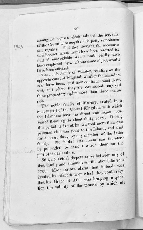
A historical and legal document discussing the motivations for the Crown's re-acquisition of regality rights in the Isle of Man, and comparing the proprietory rights held by the noble families of Stanley and Murray over several centuries. The text notes that the Murray family's thirty-year tenure involved minimal personal engagement with the Island, and references a significant dispute arising around 1780 concerning the validity of land tenures.
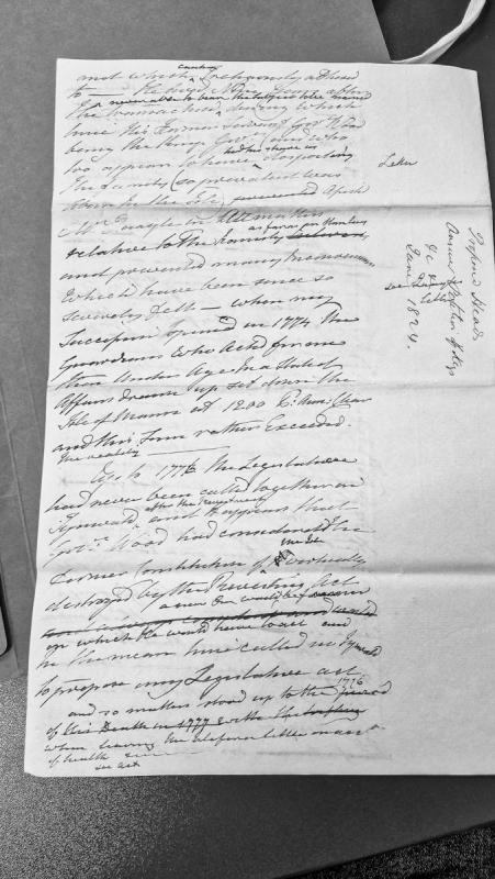
A historical narrative discussing the administration of the Isle of Man following the Revestment Act, focusing on Governor Wood's tenure and the state of the legislature. The document addresses matters of succession, constitutional arrangements, and governance practices during the period leading up to 1777.
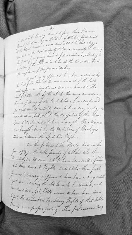
A historical narrative discussing the descent of the Receiver General Christian, the Duke of Athole's visit to the Isle of Man, and the consequences of the Act of Settlement in the early 18th century. The text addresses the transfer of lordship from the Stanley line to the Athole family in 1737 and critiques the new lords' management of their hereditary rights.
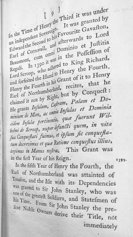
A historical narrative tracing the ownership and sovereignty of the Isle of Man from the reign of Henry III through the early 15th century. The document details grants made by Edward II to Gaveston and Lord Beaumont, the forfeiture under Henry IV following Lord Scroop's adherence to Richard II, and the subsequent grant to the Earl of Northumberland and Sir John Stanley.