
Items
Isle Of Man Bank Market Square Castletown
This building on The Parade is registered as the former premises of the Isle of Man Bank. No further documented history beyond the registration record was found.
Isle of Man Government War Memorial, Government Offices, Douglas (IOM_NIWM_DOU_00016)
3 names listed in alphabetical order, with regiment. Two names also include place of death; First World War. Wooden tablet with carved inscription.
The memorial was sponsored by members of the staff from Government Offices. It was previously located in a different department within Government Offices. In 2007 it was moved to the entrance foyer of the main office, during the office refurbishment.
Isle of Man Great War Roll of Honour, Christ Church, Laxey (IOM_NIWM_LON_00010)
This roll of honour in book form is one of the original books printed by the War Pensions Committee in 1934, and donated to each parish church throughout the Island, to commemorate those who had fallen in the Great War. 1,480 names listed. First World War.
A letter dated 2 December 1936 from R.D. Farrant, Chairman of the War Pensions Committee, was distributed with the book: "Dear Vicar, The War Pensions Committee (for which I am Chairman) sometime ago decided to prepare a list of all Manxmen who were killed or died as a result of their service in the Great War and also of those who obtained decorations and honours. Thanks to the generosity of the Earl of Derby, they were able to publish this list in book form (it has been offered for sale at 12/6d) and they are now able to present one of these volumes to each Parish Church in the Island where it will be deposited with the Church Records and available for reference by anyone interested. I have pleasure therefore in forwarding you a copy of the book for such purpose and shall be glad to hear that the gift is acceptable."
The foreword, by the Earl of Derby: "As President of the North-Western Area of the British Legion, I must offer you my most grateful thanks for having undertaken the work of compiling the Manx Roll of Honour. It is well that the deeds of those who died in the Great War should find a permanent memorial in such a list. Whilst this generation lives their names will not be forgotten, but other generations will arise to whom they will not be personally known. This Roll will serve to keep their memory green and future Manxmen and Manxwomen, when reading it, will realise that in our great struggle the Isle of Man played a noble part."
The preface, by R.D. Farrant: "This Book is intended to form an authoritative record of all Manxmen who lost their lives on active service in the Great War of 1914 to 1918, or have since died as a result of wounds, injury or disease contracted on active service. It has been compiled by the Isle of Man War Pensions Committee and their staff, from all available official and other sources and sets out, as far as can be ascertained, the names, addresses and regimental or naval particulars of every deceased sailor, soldier or airman of Manx Nationality."
Isle of Man Great War Roll of Honour, St Brendan's Church, Braddan (IOM_NIWM_BRA_00005)
This roll of honour in book form is one of the original books printed by the War Pensions Committee in 1934, and donated to each parish church throughout the Island, to commemorate those who had fallen in the Great War. 1,480 names listed. First World War.
A letter dated 2nd December 1936 from R.D. Farrant, Chairman of the War Pensions Committee, was distributed with the book: "Dear Vicar, The War Pensions Committee (for which I am Chairman) sometime ago decided to prepare a list of all Manxmen who were killed or died as a result of their service in the Great War and also of those who obtained decorations and honours. Thanks to the generosity of the Earl of Derby, they were able to publish this list in book form (it has been offered for sale at 12/6d) and they are now able to present one of these volumes to each Parish Church in the Island where it will be deposited with the Church Records and available for reference by anyone interested. I have pleasure therefore in forwarding you a copy of the book for such purpose and shall be glad to hear that the gift is acceptable."
The foreword, by the Earl of Derby: "As President of the North-Western Area of the British Legion, I must offer you my most grateful thanks for having undertaken the work of compiling the Manx Roll of Honour. It is well that the deeds of those who died in the Great War should find a permanent memorial in such a list. Whilst this generation lives their names will not be forgotten, but other generations will arise to whom they will not be personally known. This Roll will serve to keep their memory green and future Manxmen and Manxwomen, when reading it, will realise that in our great struggle the Isle of Man played a noble part."
The preface, by R.D. Farrant: "This Book is intended to form an authoritative record of all Manxmen who lost their lives on active service in the Great War of 1914 to 1918, or have since died as a result of wounds, injury or disease contracted on active service. It has been compiled by the Isle of Man War Pensions Committee and their staff, from all available official and other sources and sets out, as far as can be ascertained, the names, addresses and regimental or naval particulars of every deceased sailor, soldier or airman of Manx Nationality."
Isle of Man Great War Roll of Honour, St Lupus Church, Malew (IOM_NIWM_MAL_00008)
This roll of honour in book form is one of the original books printed by the War Pensions Committee in 1934, and donated to each parish church throughout the Island, to commemorate those who had fallen in the Great War. 1,480 names listed. First World War.
A letter dated 2 December 1936 from R.D. Farrant, Chairman of the War Pensions Committee, was distributed with the book: "Dear Vicar, The War Pensions Committee (for which I am Chairman) sometime ago decided to prepare a list of all Manxmen who were killed or died as a result of their service in the Great War and also of those who obtained decorations and honours. Thanks to the generosity of the Earl of Derby, they were able to publish this list in book form (it has been offered for sale at 12/6d) and they are now able to present one of these volumes to each Parish Church in the Island where it will be deposited with the Church Records and available for reference by anyone interested. I have pleasure therefore in forwarding you a copy of the book for such purpose and shall be glad to hear that the gift is acceptable."
The foreword, by the Earl of Derby: "As President of the North-Western Area of the British Legion, I must offer you my most grateful thanks for having undertaken the work of compiling the Manx Roll of Honour. It is well that the deeds of those who died in the Great War should find a permanent memorial in such a list. Whilst this generation lives their names will not be forgotten, but other generations will arise to whom they will not be personally known. This Roll will serve to keep their memory green and future Manxmen and Manxwomen, when reading it, will realise that in our great struggle the Isle of Man played a noble part."
The preface, by R.D. Farrant: "This Book is intended to form an authoritative record of all Manxmen who lost their lives on active service in the Great War of 1914 to 1918, or have since died as a result of wounds, injury or disease contracted on active service. It has been compiled by the Isle of Man War Pensions Committee and their staff, from all available official and other sources and sets out, as far as can be ascertained, the names, addresses and regimental or naval particulars of every deceased sailor, soldier or airman of Manx Nationality."
Isle of Man Great War Roll of Honour, St Michael's Church, Kirk Michael (IOM_NIWM_MIC_00004)
This roll of honour in book form is one of the original books printed by the War Pensions Committee in 1934, and donated to each parish church throughout the Island, to commemorate those who had fallen in the Great War. 1,480 names listed. First World War.
A letter dated 2 December 1936 from R.D. Farrant, Chairman of the War Pensions Committee, was distributed with the book: "Dear Vicar, The War Pensions Committee (for which I am Chairman) sometime ago decided to prepare a list of all Manxmen who were killed or died as a result of their service in the Great War and also of those who obtained decorations and honours. Thanks to the generosity of the Earl of Derby, they were able to publish this list in book form (it has been offered for sale at 12/6d) and they are now able to present one of these volumes to each Parish Church in the Island where it will be deposited with the Church Records and available for reference by anyone interested. I have pleasure therefore in forwarding you a copy of the book for such purpose and shall be glad to hear that the gift is acceptable."
The foreword, by the Earl of Derby: "As President of the North-Western Area of the British Legion, I must offer you my most grateful thanks for having undertaken the work of compiling the Manx Roll of Honour. It is well that the deeds of those who died in the Great War should find a permanent memorial in such a list. Whilst this generation lives their names will not be forgotten, but other generations will arise to whom they will not be personally known. This Roll will serve to keep their memory green and future Manxmen and Manxwomen, when reading it, will realise that in our great struggle the Isle of Man played a noble part."
The preface, by R.D. Farrant: "This Book is intended to form an authoritative record of all Manxmen who lost their lives on active service in the Great War of 1914 to 1918, or have since died as a result of wounds, injury or disease contracted on active service. It has been compiled by the Isle of Man War Pensions Committee and their staff, from all available official and other sources and sets out, as far as can be ascertained, the names, addresses and regimental or naval particulars of every deceased sailor, soldier or airman of Manx Nationality."
Isle of Man Great War Roll of Honour, St Sanctain's Church, Santon (IOM_NIWM_SAN_00004)
This roll of honour in book form is one of the original books printed by the War Pensions Committee in 1934, and donated to each parish church throughout the Island, to commemorate those who had fallen in the Great War. 1,480 names listed. First World War.
A letter dated 2 December 1936 from R.D. Farrant, Chairman of the War Pensions Committee, was distributed with the book: "Dear Vicar, The War Pensions Committee (for which I am Chairman) sometime ago decided to prepare a list of all Manxmen who were killed or died as a result of their service in the Great War and also of those who obtained decorations and honours. Thanks to the generosity of the Earl of Derby, they were able to publish this list in book form (it has been offered for sale at 12/6d) and they are now able to present one of these volumes to each Parish Church in the Island where it will be deposited with the Church Records and available for reference by anyone interested. I have pleasure therefore in forwarding you a copy of the book for such purpose and shall be glad to hear that the gift is acceptable."
The foreword, by the Earl of Derby: "As President of the North-Western Area of the British Legion, I must offer you my most grateful thanks for having undertaken the work of compiling the Manx Roll of Honour. It is well that the deeds of those who died in the Great War should find a permanent memorial in such a list. Whilst this generation lives their names will not be forgotten, but other generations will arise to whom they will not be personally known. This Roll will serve to keep their memory green and future Manxmen and Manxwomen, when reading it, will realise that in our great struggle the Isle of Man played a noble part."
The preface, by R.D. Farrant: "This Book is intended to form an authoritative record of all Manxmen who lost their lives on active service in the Great War of 1914 to 1918, or have since died as a result of wounds, injury or disease contracted on active service. It has been compiled by the Isle of Man War Pensions Committee and their staff, from all available official and other sources and sets out, as far as can be ascertained, the names, addresses and regimental or naval particulars of every deceased sailor, soldier or airman of Manx Nationality."
Isle of Man Great War Roll of Honour, St Thomas' Church, Douglas
This roll of honour in book form is one of the original books printed by the War Pensions Committee in 1934, and donated to each parish church throughout the Island, to commemorate those who had fallen in the Great War. 1,480 names listed. First World War.
A letter dated 2nd December 1936 from R.D. Farrant, Chairman of the War Pensions Committee, was distributed with the book: "Dear Vicar, The War Pensions Committee (for which I am Chairman) sometime ago decided to prepare a list of all Manxmen who were killed or died as a result of their service in the Great War and also of those who obtained decorations and honours. Thanks to the generosity of the Earl of Derby, they were able to publish this list in book form (it has been offered for sale at 12/6d) and they are now able to present one of these volumes to each Parish Church in the Island where it will be deposited with the Church Records and available for reference by anyone interested. I have pleasure therefore in forwarding you a copy of the book for such purpose and shall be glad to hear that the gift is acceptable."
The foreword, by the Earl of Derby: "As President of the North-Western Area of the British Legion, I must offer you my most grateful thanks for having undertaken the work of compiling the Manx Roll of Honour. It is well that the deeds of those who died in the Great War should find a permanent memorial in such a list. Whilst this generation lives their names will not be forgotten, but other generations will arise to whom they will not be personally known. This Roll will serve to keep their memory green and future Manxmen and Manxwomen, when reading it, will realise that in our great struggle the Isle of Man played a noble part."
The preface, by R.D. Farrant: "This Book is intended to form an authoritative record of all Manxmen who lost their lives on active service in the Great War of 1914 to 1918, or have since died as a result of wounds, injury or disease contracted on active service. It has been compiled by the Isle of Man War Pensions Committee and their staff, from all available official and other sources and sets out, as far as can be ascertained, the names, addresses and regimental or naval particulars of every deceased sailor, soldier or airman of Manx Nationality."
The roll of honour in St Thomas' church is placed on a prayer desk in the north aisle of the church.
Information provided by the Isle of Man Government Preservation of War Memorials Committee. Image courtesy of Chris Blyth, Isle of Man Photographic Society.
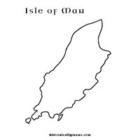
Isle of Man Map Colouring Sheet
A map of the Isle of Man to colour.
Isle of Man Purchase Act
The Isle of Man Purchase Act (5 Geo. III, c. 26) received Royal Assent. Parliament purchased the Duke of Atholl's sovereignty and revenue rights for £70,000. The Act was titled 'for the more effectual preventing of the mischiefs arising to the Revenue and Commerce of Great Britain and Ireland, from the illicit and clandestine Trade to and from the Isle of Man.' Parliament bought a feudal title. It did not acquire the Manx nation. It did not assume the duty of governance.
Isle of Man Purchase Act 1765
Westminster legislation confirming the Crown’s purchase of the sovereign rights of the Isle of Man from the Duke and Duchess of Atholl in 1765.
Parliament had authorised negotiation for a purchase as early as 1725. In 1765 a contract was concluded with John, third Duke of Atholl, and Charlotte, Duchess of Atholl, for surrender of the sovereign rights which Charlotte had inherited through the Stanley line.
The agreement was confirmed by Act of Parliament on 10 May 1765. The consideration was £70,000. The Manx constitutional account later printed by the Manx Society states that, once payment was made, the Island was to be vested in the King and his successors.
The transfer was not a purchase of every Atholl interest on the Island. Ecclesiastical patronage, lands and other proprietary rights not necessarily included within the sovereignty were expressly reserved. Those remaining rights were dealt with separately during the nineteenth century.
The change altered the first estate of the Manx legislature rather than abolishing the legislature itself. Before 1765 legislation had been enacted by the Lord of Man with the other estates of Tynwald. After Revestment the Crown occupied that position. Manx courts and the existing legislative structure continued to operate, now in the name of the British sovereign.
Isle of Man Railway
Modern narrow-gauge railway.
The Isle of Man Railway Company completed its first line between Douglas and Peel in 1873.
The 3-foot narrow-gauge system was extended by the completion of a second line between the main station at Douglas and Port Erin in the south-west of the island in 1874. Separately, the Manx Northern Railway constructed a line from St John's (on the route between Douglas and Peel) in 1879 and from 1886 operated another short line between St John's and Foxdale, exploiting the mining traffic arising from the latter. The railway companies amalgamated in 1904.
The Peel line closed to passenger services in 1968, and to goods traffic the following year, and was dismantled in the 1970s.
The grid reference relates to a short length of restored track next to the water tower, south of which the line extended up the valley and then towards St John's.
The railway terminus at Peel is now built over, though the station building and goods shed both survive and are repurposed as part of the House of Manannan heritage centre.
Isle of Man Railway
A record for the Isle of Man Railway which was a 3-foot gauge line which operated from 1873 onwards between Douglas and Peel. The Isle of Man Railway continued in operation until closure in 1968.
Isle of Man Railway
The Isle of Man Railway was opened in 1873 and linked Douglas and Peel. This line was closed in 1968 and later dismantled. A 3 foot gauge line was built between Douglas and Port Erin in 1874, which continues to operate for passengers.
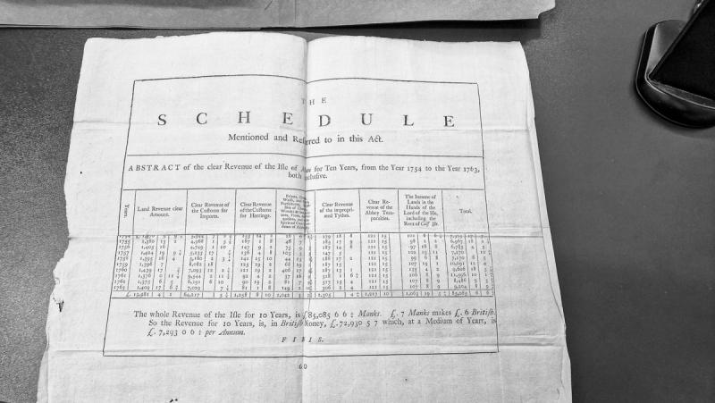
Isle of Man Revenue Abstract for 1754-1763
A financial abstract presenting annual revenue figures for the Isle of Man across a ten-year period (1754-1763), with totals calculated in Manks currency and converted to British money. The document shows various revenue categories organized in columns with amounts in pounds, shillings, and pence.
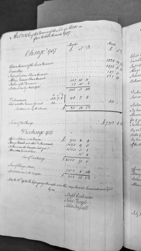
Isle of Man Revenue Account for 1757 with Audit Certification
A financial abstract showing the revenue charges and discharges for the Isle of Man for the year 1757, including land revenue, casualties, impropriations, abbey revenue, and steward accounts. The document concludes with an audit certification dated July 21, 1758, signed by three auditors confirming the accounts have been examined and passed.
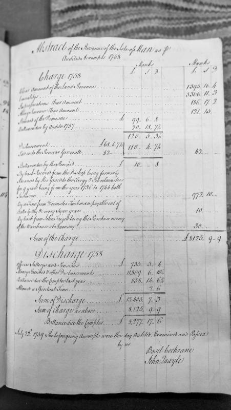
Isle of Man Revenue Account for 1758, Audited July 1759
A financial account for the Isle of Man covering the year 1758, detailing charges and discharges of revenue from land, casualties, impropriations, and abbey revenues. The document records receipts, disbursements, and balances, with a final balance due to the Comptroller of £5,277.17.6. It was audited and passed by Basil Cochrane and John Quayle on 23 July 1759.
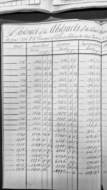
Isle of Man revenue accounts tabulated by year, 1736–1756.
A financial table recording annual revenue data for the Isle of Man spanning from 1736 to 1756. The document presents multiple columns of numerical values in pounds, shillings, and pence, likely representing different categories of revenue or taxation. Several entries contain uncertain or partially legible readings indicated by question marks.
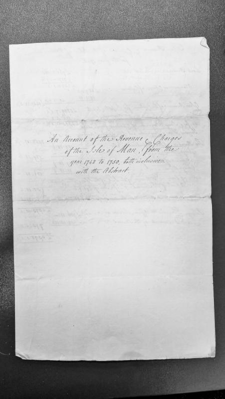
Isle of Man Revenue and Charges Account 1742-1750 with Abstract
A revenue abstract document detailing the financial accounts and charges for the Isle of Man spanning the period from 1742 to 1750 inclusive. This document appears to be an official administrative record of governmental revenues and expenditures for the island during this eight-year period.
Isle of Man Steam Packet Company in the First World War
During the First World War, eleven of the Steam Packet Company's fleet of fifteen ships were requisitioned by the Admiralty; four were lost, three retained by government and four returned to civilian service. The Ben-my-Chree, built in 1907, was requisitioned in 1915 and converted into a seaplane carrier, while the Viking became one of the earliest vessels converted to an aircraft carrier as HMS Vindex. The King Orry, attached to the Grand Fleet, had the distinction of leading the surrendered German High Seas Fleet into Scapa Flow at the war's end.
Isle of Man Steam Packet Ships at Dunkirk, 1940
Two Isle of Man Steam Packet Company vessels, both launched on the same day in 1936, played dramatic roles in the Dunkirk evacuation (Operation Dynamo) of May-June 1940. The Tynwald made four trips between 28 May and 4 June, embarking more troops than any other company vessel (around 8,953 in total) and was the last ship to leave, landing 3,000 French troops in England; she was later requisitioned as HMS Tynwald and sunk by an Italian submarine torpedo off North Africa in November 1942. The Fenella, on her first run into Dunkirk on 29 May 1940 under Captain W. Cubbon, was hit by three bombs while loading around 650 troops from the East Pier and sank; of her 48 crew, 33 reached Dover, and steward Thomas Helsby became the only Steam Packet crewman taken prisoner.
Isle of Man Steam Packet War Memorial, IOM Steampacket Headquarters, Douglas (IOM_NIWM_DOU_00021)
The memorial consists of a window and a plaque. No names listed; Second World War. Isle of Man Steam Packet house flag on the top centre of the wooden plaque.
The memorial was sponsored by the Isle of Man Steam Packet Co. Ltd. The monument was originally situated in St Barnabas' Church, Douglas until November 1969, when it was relocated to the Steam Packet Headquarters, due to St Barnabas' Church being demolished. Following the re-siting of the window, the varnished wooden plaque measuring 2.75" x 31.5" was situated immediately below the window.
Information provided by the Isle of Man Government Preservation of War Memorials Committee. Image courtesy of Chris Blyth, Isle of Man Photographic Society.
Isle of Man Women's Suffrage
Nineteenth-century reform of the Manx electoral franchise which admitted women to voting in elections for the House of Keys.
The first elected House of Keys was created in 1866, but the franchise remained restricted. Further reform followed through the House of Keys Election Act 1881.
A contemporary constitutional note records that the 1881 Act based the franchise on ownership or tenancy of real estate of at least £4 annual rateable value, together with certain lodger qualifications. Under the ownership qualification, unmarried women were admitted as voters.
The Keys had proposed that the tenancy qualification should also extend to women, but the Legislative Council did not accept that part of the measure. Women’s enfranchisement was therefore real but limited by both marital status and the property basis of the franchise.
The reform was closely associated with Richard Sherwood, member of the Keys for Glenfaba from 1869. A later Manx biographical account describes him as the introducer of female suffrage and also credits him with the Ballot Act and other electoral reforms.
The 1881 settlement did not produce universal adult suffrage. It extended the vote to a defined class of women within an electoral system still based heavily on property qualifications.
Isle of Man's First Submarine Telegraph Cable, 1859
The Isle of Man Electric Telegraph Company, formed in 1859, connected the island to the wider telegraph network via a 36-nautical-mile submarine cable laid from Cranstal, north of Ramsey, to St Bees in Cumbria in August 1859, using the chartered cable ship Resolute. Strong currents at Cranstal proved unworkable, and in 1864 the cable was lifted and relaid further south at Port-e-Vullen in Ramsey Bay, marking the start of the island's direct telecommunications link to Britain.

Issue Roll for Isle of Man, 1393 (16 Ric. II) — Payment to Bishop Waldby
An extract from a medieval Issue Roll (Royal Exchequer record) documenting a payment of £66 13s. 4d. to the Bishop of Man in 1393, issued via the Bishop of Salisbury and Treasurer of England. The payment compensated the Bishop for charges and labour in prosecuting affairs for the Crown in the Islands. This is a primary administrative/revenue document from the Manx Society's published collection of medieval Manx records.