Merchant of Castletown and Speaker of the House of Keys at the time of the 1792 inquiry.
He was returned to the Keys in 1752 and sat there for the rest of his life. Examined by the Commissioners of Inquiry at Castletown on Saturday 15 October 1791, he told them he had been a member of the House these forty years and upwards, and Speaker for six or seven, and that the House consisted of twenty-four members filling their own vacancies.
His evidence is one of the fullest accounts of how the Keys actually worked. He described the closing of a session, when the Speaker informs the Governor that the business is finished, asks whether he has any further commands, and then adjourns the House without a day. He set out the original jurisdiction of the Keys over complaints against their own members in their public capacity, and over libel or scandal touching the public magistrates or the House itself. He held that the attestation of Governor, Council and Keys to the promulgation of an Act of Tynwald was the act of each of those persons signing in a legislative capacity. He had also, for some years, superintended the application of the Lord's carriage services for the southern division, which went to the repairs of Castle Rushen and to work on the Lord's demesnes.
He led the House's dealings with the inquiry. In September 1791 the Keys appointed him first of a committee of seven to attend the Commissioners on the Duke of Atholl's claims, and in October he signed their observations on the public buildings and harbours as Speaker.
His own claim ran alongside. He and John Stevenson petitioned the Commissioners over the old harbour debts in October 1791, and Taubman separately memorialised the Treasury for a debt settled at £337 3s 4½d English in December 1774, which with interest at six per cent and one payment received stood at £602 12s 6¼d by 1790.
John Tear, born in 1760, who emigrated from the Isle of Man in 1826 and died in America in 1841.
He was one of the first of the Manx settlers in Ohio, going out in the year the Cleveland district was opened, and he was a Wesleyan. His tombstone in the Brakeman Cemetery in the Leroy district describes him as a follower of Wesley, under whose ministry he had sat, and gives his birth, his emigration and his death. Patrick and Ann Tear were among the three families who made up that first party of 1826.
John Wattleworth was a Ramsey fisherman whose boat was illegally seized in Ramsey Bay in November 1765, six months after the Revestment. He petitioned for its return alongside John Sayle and John Kneene.
Administrative letter from John Wetherall to the Irish Revenue Commissioners reporting on seized goods identified as coming from the Isle of Man. The document describes methodology for identifying smuggled goods (the 'Isle Man package' — tea in small casks, tobacco in trusses, brandy, geneva, and rum in ankers) and lists values of seized items. Directly relevant to understanding smuggling patterns and revenue operations immediately before the Revestment.
Governor of the Isle of Man before and after the Revestment, in office from the early 1760s until the later 1770s.
His surviving letters to the Duke of Atholl run from 1762 to October 1764, and much of their business is money. They record the remittances sent over regularly to the Lord of Man, among them £1,100 British despatched with the Michaelmas abstract by Charles Lace, who was held by contrary winds and storms long after the sailing and reached Liverpool safely in the end. The quarterly abstracts of imports were the instrument by which the state of the Island's trade was laid before its proprietor, and Wood noted the wrecks of ships bound for the Isle by which the Duke's revenues suffered.
Writing from Castletown in December 1762, he reported that the box of tithe conveyances had arrived safe and that he had received the King's commands to proclaim the cessation of arms, which he hoped would put more spirit into a trade that had seemed for some months to be declining.
On the death of the second Duke he set the Island's mourning in order, arranging for minute guns to be fired for an hour on the return from chapel and directing enquiry into whether the parish churches had customarily been hung with mourning. He also recalled the interim commission he had given to young Taubman, acting on a paragraph in the late Duke's last letter which had wished the surviving Deemster to carry both offices, and their perquisites, until a successor could be settled by established rules.
Revestment changed whom he served rather than what he did. His predecessors had sworn to deal uprightly between the Lord and his people. Wood's own oath as Governor bound him to deal truly and uprightly between the King and his subjects within the Isle, and as indifferently between party and party as the staff of office then stood, and to call the Council together whenever he thought it necessary. His warrant of appointment as Governor under the Crown was issued by Sandwich on 21 June 1765. In March of that year, in the weeks when the sale was before Parliament, it was to Wood that George Moore applied for the Keys to be convened, and Wood who issued the precepts.
The new revenue establishment brought a jurisdictional quarrel. In 1771 he wrote to the Treasury complaining of deputations issued to revenue officers, arguing that the office and jurisdiction of the Water-Bailiff had not been properly explained to their Lordships, and warning of the confusion and clashing of jurisdictions likely to follow. Charles Lutwidge answered him in the same file. Wood was succeeded as Governor-in-Chief by Colonel Edward Smith.
Letter from John Wood (likely Governor of Isle of Man) to the Treasury dated 27 June 1770, protesting that Revenue Officers issued orders to Civil and Military officers without gubernatorial authority or knowledge. Wood notes receipt of duplicate letters regarding potential plague vessels and raises constitutional concerns about the Treasury's direct exercise of power over island officials.
Letter from John Wood, Governor of the Isle of Man, to the Board of Customs acknowledging receipt of their letter of 23 May 1765 and confirming his readiness to execute orders. Wood notes he awaits formal directions from the Crown and the Duke of Atholl regarding necessary measures. This correspondence dates to the critical transition period immediately after the Revestment Act (1765) and reveals the administrative uncertainty during implementation.
Joseph Hubertus Pilates (1883-1967) was a German-born physical fitness instructor who gave his name to the Pilates method of exercise. Living in England at the outbreak of the First World War, he was interned as an enemy alien and transferred from Lancaster to Knockaloe on 12 September 1915, where he is believed to have been held in Camp 4. He was repatriated to Germany in March 1919.
The documented trace of his years at Knockaloe is slight. The one firm camp record is the Camp 4 newspaper, the Lager Zeitung of 25 January 1917, which names him as referee at a boxing match, disqualifying one contestant for ignoring his instructions. Beyond this, the record of his time on the Island rests largely on his own later recollections.
Much of the popular Pilates origin story is legend rather than record. The founding tale of his equipment, that he worked as a hospital orderly and rigged springs from internees' bed frames, is unproven. The Knockaloe Charitable Trust finds no evidence of hospital work, and his biographer Javier Perez Pont found no such springs on the camp beds. The story that he took inspiration from watching cats comes from his own interview with Robert Wernick in Sports Illustrated in February 1962, which places the cats at the camp on the Isle of Man. That some of those cats would have been Manx is a reasonable inference, but the sources say only "cats", never "Manx cats", and the familiar claim that he copied his movements from Manx cats goes beyond anything the record supports.
Joseph Mylchreest (c. 1839 - 28 December 1896), known as 'the Diamond King', was born in Peel and apprenticed as a ship carpenter before travelling through Africa, Australia, New Zealand, and the Americas as a prospector, eventually striking success at the Kimberley diamond fields in South Africa in the 1870s (the mine he developed became known as the Balfontein Mine). He returned to the Isle of Man in 1888 a wealthy man, becoming a magistrate and Member of the House of Keys for Peel and a notable benefactor of Manx causes; a memorial window to him survives in Kirk Michael Church, and his South African career is said to have inspired an episode in Hall Caine's novel The Manxman.
Margaret Letitia Josephine Kermode (18 September 1852 - 15 February 1937), who wrote under the pen name 'Cushag' (Manx for ragwort, the unofficial national flower), was a Manx dialect poet born in Ramsey. Her first collection, Poems by Cushag, appeared in 1907 and captured the speech and beliefs of Manx crofters in verse; she was a sister of P.M.C. Kermode, first Director of the Manx Museum, for whom she later kept house. A memorial to her was unveiled at Maughold churchyard in 1944.
A historical essay on the Dublin banker Richard McGwire and Liverpool merchant Josiah Poole, who farmed the Isle of Man customs from 1720 and became major operators in the contraband trade. Covers their customs lease, smuggling operations in tobacco, spirits, wine, and East India goods, disputes with Crown officers, and McGwire's death in 1727. Directly relevant to understanding the commercial interests and illicit trade networks that preceded the 1765 Revestment.
A detailed historical narrative of the customs farming activities of Richard McGwire (Dublin banker) and Josiah Poole (Liverpool merchant) on the Isle of Man from 1720 onwards. The article documents their smuggling operations in tobacco, spirits, wine, and East India goods, their recruitment of customs collectors and officers, the exposure of their activities by Joshua Robinson, McGwire's death in 1727, and the broader context of the running trade that eventually prompted the 1765 Revestment. Directly relevant to understanding the economic and operational foundations of Manx smuggling before Parliamentary intervention.
The Jubilee Clock stands at the foot of Victoria Street where it meets Loch Promenade, a Victorian clock tower donated by G. W. Dumbell in 1887 to mark the Golden Jubilee of Queen Victoria's reign. It originally had a horse trough built into its base, reflecting the horse-drawn traffic of the promenade in that era, and it remains one of the most recognisable small landmarks at the heart of Douglas's seafront.
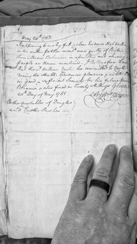
A judicial order dated May 28, 1765, committing William Cashin to Castle Rushen for riotous and tumultuous behaviour involving assault and abuse. The order imposes imprisonment at the Governor's pleasure, requires security for future good behaviour, and levies a fine of twenty shillings.
This airfield was established as an RAF base in 1938, built on land acquired from the Ballamoar Estate. RAF Jurby closed in 1963 but the airfield is still maintained and used for civilian purposes. An industrial estate, the Isle of Man Prison and the Isle of Man Motor Museum are now located here.
This Bomb Store formed part of RAF Jurby's wartime technical infrastructure. The airfield opened in 1939 and trained bomber crews, later contributing aircraft to Bomber Command's 1942 'Operation Millennium' thousand-bomber raid, work that required substantial on-site munitions storage. No historical detail specific to this individual bomb store building beyond its registration and the station's general wartime role could be verified online.
A cropmark of a ditched trackway system discovered on an aerial photograph taken in 1979 on the north side of Jurby airstrip around which there is a major concentration of crop-mark evidence. It has been suggested that the trackway may have been made during construction work on Jurby airfield.
Prehistoric flint scatter.
A small quantity of worked prehistoric flint was recovered from Jurby Brooghs by CH Cowley.
As Cowley elsewhere records discoveries at Jurby Point (Jurby Head), Jurby Church Brooghs, and Sartfield Brooghs, it is possible that he meant to define a separate location. He may again have been attracted by the burial mound, since destroyed, at Ballasalla farm, to the vicinity of which the grid reference refers for indicative purposes only.
The antiquary Charles Harry Cowley was an avid collector of worked flint and coarse stone artefacts revealed by agricultural activity, mainly on farms located around Peel, and occasionally from further afield. He was active from 1900 until 1943. His entire collection of artefacts, together with a daybook cataloguing his discoveries, was later donated to Manx National Heritage.
A scatter of Mesolithic flint artefacts was found along a long section of coastal cliffs opposite Jurby Church and around the mouth of Killane river, collected from eroding cliffs and nearby fields. They included flint cores, blades, flakes and microliths. They are now kept at the Manx Museum.
Prehistoric flint scatter.
A small quantity of worked prehistoric flint was recovered from Jurby by CH Cowley, from 'Jurby Church Brooghs'.
The description refers to the area seaward of the parish church, centred at the grid reference provided. The coastline has since eroded back around 30metres since Cowley was active.
The antiquary Charles Harry Cowley was an avid collector of worked flint and coarse stone artefacts revealed by agricultural activity, mainly on farms located around Peel, and occasionally from further afield. He was active from 1900 until 1943. His entire collection of artefacts, together with a daybook cataloguing his discoveries, was later donated to Manx National Heritage.
Medieval burial mound. The mound is located in the parish churchyard. It has a diameter of 14m, though this is now a little indistinct because of subsequent disturbance, and stands to a height of 2m. Later graves, of mostly 19th century date, have been cut into the mound. Gravedigging at one point revealed a sword, of reputedly Viking Age date, though this was immediately reburied. A second sword has also been found in the graveyard, but its fate is not clear.