Charles Lutwidge reports to the Treasury Lords that the Keys of the Isle of Man have enacted statutes at Castletown, including one on licensing spirituous liquors, which may affect royal revenue. Written in September 1774, this is the first legislative exercise by the Keys since the 1765 Revestment. Lutwidge notes the absence of an Attorney General and urges that authentic copies be obtained before royal assent is granted.
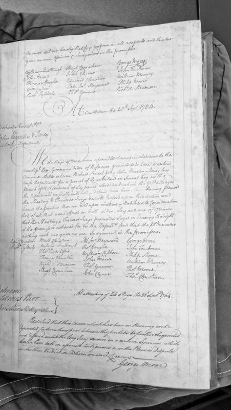
A House of Keys judgment dated 20 September 1764 concerning a dispute over a parcel of quarterland in Kneal beg, Kirk Andreas parish, with six pence lord rent. The Keys upheld the verdict of the Sheading and Traverse Juries in favour of the defendants, denying the plaintiff's claim. The document also includes a subsequent resolution from 28 September 1764 to suspend another case between James Parr and Christian Kelley pending a jury verdict on a disputed licence.
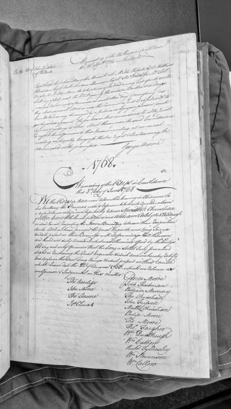
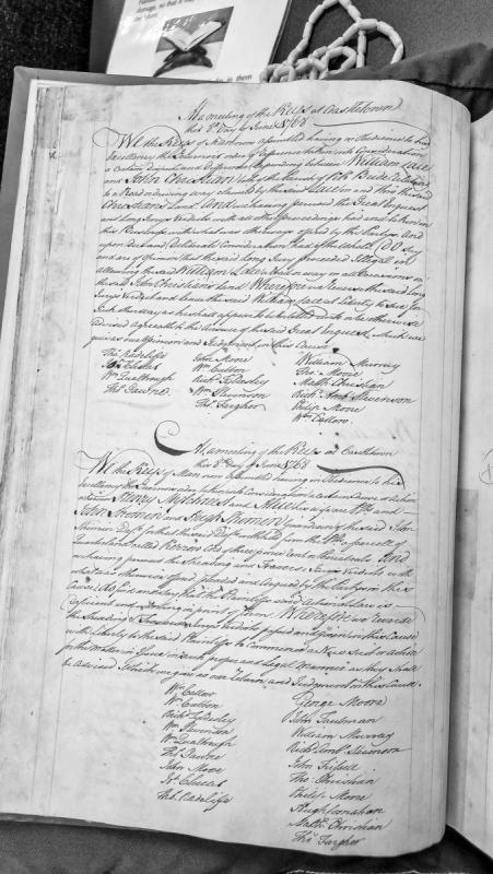
A judgment delivered by the Keys of Man at Castletown ratifying a Long Jury verdict from August 1765 concerning a boundary dispute between Mondus Christian of Ellen Vane and William Corlet of the Claddagh, both in the Parish of Bride. The Keys confirmed the Long Jury's reversal of the Great Inquest's original verdict.
A House of Keys judgment from Castletown reversing lower jury verdicts in a land dispute between Henry Mitchell and his wife (plaintiffs) against John Shimmin and Hugh Shimmin (defendants) concerning a parcel of land called Kerrow. The Keys found the plaintiffs' action deficient in form and granted them liberty to commence a new suit in proper legal manner.
The House of Keys passed a formal resolution opposing the sale of the Island. The signatories — the elected representatives of the Manx people — recorded their opposition 'as much as in them lies.' They sent Hugh Cosnahan to London to deliver the petition. Parliament received it and ignored it.
Resolution of the House of Keys appointing representatives to protect Manx interests during the negotiations for Revestment.
The Keys met at Castletown on 21 March 1765 after learning that the British government was negotiating with the Duke and Duchess of Atholl for the “superiority and dominion” of the Island and that the matter was before Parliament.
The resolution stated that the rights and properties of the inhabitants might be affected unless a proper application was made on their behalf. The House therefore decided to appoint commissioners to go immediately to London.
Their instructions were explicit. They were to attend the parliamentary business and endeavour to preserve “the inherent and Constitutional Rights of the People of this Isle” as far as they could. They were also directed to seek just and reasonable terms for the good of the community and the welfare of Mann.
The resolution formed part of a rapid sequence of actions by the Keys. On 8 March members had written to their Speaker asking him to seek a meeting of the House. The Speaker wrote to the Governor on 12 March, and the Governor replied on 14 March. On 21 March the Keys appointed their commissioners, issued instructions to them and addressed the Duke and Duchess of Atholl.
The same documentary sequence also includes the petition subsequently presented by the House of Keys to the British House of Commons.
Finds recovered from a field on Kilkenny Farm are indicative of a medieval settlement being located here. The finds included a hoard of medieval coins, various metal objects of later date and sherds of red, unglazed tiles.
The site of a Bronze Age cairn, which is situated on a knoll protruding from the side of a very steep hill. It is a well-formed cairn with diameter of 8.0 metres and height of 0.5 metres. The prehistoric cairn is flat topped and many stones protrude from its sides, but stones piled on top of the cairn appear to be the result of field clearance in more recent times.
The site of a post-medieval horse engine. The circular horsewalk does not appear on the 1870 1:2500 scale Ordnance Survey map but the outline is visible at the southeastern edge of the farmyard complex on early 21st century aerial photographs.
This is thought to be the possible site of an early medieval keeill or chapel and its burial ground, which have been hidden in a thick forestry plantation in modern times. The foundations of a building measuring 4.6 metres by 3.2 metres and evidence of graves have reportedly been seen here.
This is thought to be the possible site of an early medieval keeill or chapel, which has been hidden in a thick forestry plantation in modern times. The foundations of a building measuring 4.6 metres by 3.2 metres and evidence of graves have reportedly been seen here. The placename is said to possibly be a corruption of St Bridget or Breaga.
A corn mill is shown here on the 1869 I:2500 scale Ordnance Survey map. The original mill buildings may survive within a range of larger, modern buildings which now occupy this coast-edge site at the mouth of the Killane River. In the 19th century a large, dammed millpond existed to the east of the mill, fed by the river.
A lime kiln shown at this location on the 1870 1:2500 Ordnance Survey map has been lost to coastal erosion. The Killane area of Ballaugh, on the island's north-west coastal plain, is one of the stretches of coastline most heavily affected by ongoing erosion, which has claimed land and structures here over many years.
A scattered cremation burial is also dated to this period by its associated food vessel. A smaller, broken food vessel north of this burial may be a slightly later insertion. The possibility of a ritual smashing of this pot should be considered, but could not be proved. There remain the three miniature cists (IV, V and VI) all of which are almost certainly late features of the site. Cists IV and V are dug into earlier sand layers, Cist V in particular cuts through the fill of the large cist III, while Cist IV is located in a shallow scoop just under the topsoil. The unenclosed skin-bag cremation, which lies in the filled trench of Cist I, must also belong to this latest phase. An enigmatic oval platform of rough stones was found on the North slope of the mound, but it could not be dated and might relate to either period, or indeed some other time.
This is the location of a Neolithic to Bronze Age funerary site. A 'mound of considerable dimensions' with a cist containing pottery and what was probably cremated human bones was first noted by Oswald who referred to an inspection of the site by W. Kermode when it was first ploughed about 1850. By 1880 the mound had been 'considerably reduced'.
It survived as a large grass-covered mound whose slopes flowed gradually without break into the surrounding ground. Its diameter was 40.0 metres and minimum height 2.0 metres. Despite the finds of prehistoric burials here in the 19th century, the mound was thought itself to be a natural feature.
The mound was excavated in 1968-69 in advance of building development when it was confirmed that it was indeed of natural origin, a glacial moraine, but that it had been utilised as a repository for at least eleven cremations and an inhumation of late Neolithic-Early Bronze Age dating. Finds include two urns of Ronaldsway type, three Early Bronze Age food-vessels, flint flakes and knife, arrowhead and worked stone.
Taking into consideration the radiocarbon dates, the pottery evidence, the types of burials and the stratigraphical inter-relationships where these are demonstrable, the site appears to be of two periods, Ronaldsway followed by Early Bronze Age. The initial feature appears to be the burning pit, sited just to the south of the summit of the natural mound. Three timber-lined pits were grouped around this pit on the southeast slope of the mound, two containing evidence of cremation. A fourth timber-lined pit with an associated skin-bag cremation was inserted further to the southeast. Three further shallow deposits of cremated remains were found.
The probable etymology of Killeaba or Cor-Ihiabbagh is 'the nook or corner of the tomb' or 'the grove of the tomb'.
Burials found within the Neolithic to Bronze Age funerary site at Killeaba.
The site produced two vessels of Ronaldsway type. A large urn was inserted at the highest point of the mound, North of the burning pit, its mouth apparently in part covered by a slab of stone pierced by a circular hole. The insertion of this urn post-dates the initial construction of the burning pit, which, however, may have been re-used subsequently. The smaller urn was positioned above a timber-lined pit, possibly at the time this pit was filled in. To the South a further pit of comparable size contained a roughly rectangular setting of stone similar to stone settings in some of the timber-lined pits. The stratigraphy indicates that this pit was constructed after the filling in of the first one. An enigmatic oval platform of rough stones was found on the North slope of the mound, but it could not be dated and might relate to either period, or indeed some other time. Cremated bone not associated with structures may also date from this period.
Medieval chapel, burial ground, lintel graves and Bronze Age burials.
The Ordnance Survey 1:2500 First Edition mapping of 1867 shows the site of a chapel and burial ground at this location, formerly named Killkellan, together with the annotation, 'Site of Chapel & Burial Ground'. The OS places a marker within a small enclosure to the east of the road, which is defined by a curvilinear field boundary.
The Manx Archaeological Survey (1915) recorded that many graves had been found in the locality, and that more came to light when the Manx Electric Railway was constructed in in 1894. The Survey draws attention to the nearby watercourse, Strooan ny Killane (stream of the chapel), though it could find no memory locally of the dedication of the chapel, and records that prehistoric urns had also previously been found when the adjacent school was constructed.
A Royal Commission field inspector noted in 1976 that there was no trace of the site and that it had been obliterated by the construction of the railway, residential development and an occupation road.
Medieval chapel.
The Ordnance Survey 1:2500 First Edition mapping of 1867 shows the site of a chapel and burial ground at this location, formerly named Killkellan, together with the annotation, 'Site of Chapel & Burial Ground'. The OS places a marker within a small enclosure to the east of the road, which is defined by a curvilinear field boundary.
The Manx Archaeological Survey (1915) is silent on the record made by Dr J Bradbury (1894) that 'rude foundations' within the enclosure might represent the remains of the chapel, and instead drew attention to the nearby watercourse, Strooan ny Killane (stream of the chapel), on the basis of which it inferred the existence of a chapel. It could find no memory locally of a dedication. A field to the west of the main road traditionally bore the name Bwoailley Khallane (Chapel fold), which would appear to reinforce the view that a chapel had formerly been present.
A Royal Commission field inspector noted in 1976 that there was no trace of the site and that the site had been obliterated by modern development.
Medieval burial ground.
The Ordnance Survey 1:2500 First Edition mapping of 1867 shows the site of a chapel and burial ground at this location, formerly named Killkellan, together with the annotation, 'Site of Chapel & Burial Ground'. The OS places a marker within a small enclosure to the east of the road, which is defined by a curvilinear field boundary.
The enclosure survives today, forming the curtilage boundary of a dwelling, though a Royal Commission field inspector noted in 1976 that otherwise there was no trace of the site and that it had been obliterated by the construction of the railway, residential development and an occupation road.
Medieval lintel graves.
The Ordnance Survey 1:2500 First Edition mapping of 1867 shows the site of a chapel and burial ground at this location, formerly named Killkellan, together with the annotation, 'Site of Chapel & Burial Ground'. The OS places a marker within a small enclosure to the east of the road, which is defined by a curvilinear field boundary.
Dr J Bradbury (1894), when describing the nearby archaeological discoveries at the time he was writing, recorded the earlier discovery of a few lintel graves in the enclosure, when sand was removed for the construction of Lonan All Saints Church. The church was completed in 1833, so the discovery would appear to have occurred just prior.
There is no record of any further discoveries during residential development that has taken place since.
Medieval lintel graves.
The Ordnance Survey 1:2500 First Edition mapping of 1867 shows the site of a chapel and burial ground at this location, formerly named Killkellan, together with the annotation, 'Site of Chapel & Burial Ground'. The OS places a marker within a small enclosure to the east of the road, which is defined by a curvilinear field boundary.
Dr J Bradbury (1894), when describing the nearby archaeological discoveries at the time he was writing, recorded the earlier discovery of lintel graves in the field to the east of the road, which at the time bore the name, the Cronk. This relates to Ordnance Survey Field no. 2520, and would appear to indicate the sometime presence of a raised mound or hillock. It is not altogether clear from his description, but Bradbury would appear to be referring to the more southerly part of the field. He notes that these discoveries were made on more than one occasion and were the result of agricultural activity.
Aside from the discoveries made during the later construction of the railway, there is no record of any further finds during nearby residential development.
Medieval lintel graves.
The Ordnance Survey 1:2500 First Edition mapping of 1867 shows the site of a chapel and burial ground at this location, formerly named Killkellan, together with the annotation, 'Site of Chapel & Burial Ground'. The OS places a marker within a small enclosure to the east of the road, which is defined by a curvilinear field boundary.
Dr J Bradbury (1894) describes the discovery at the time he was writing, of a 'series of graves', during construction of the Manx Electric Railway. All were lintel graves, and some 46 of them were opened; they were found to contain human skeletons, many of which crumbled on exposure. Bradbury describes the graves as being arranged in rows, but gathered into groups of three. The graves were closely spaced, but each group was separated from the next by about 3m.
The location of the discovery is not clear from Bradbury's description, but the arrangement would imply that the graves covered an extensive area along the line of the railway.
Bronze Age burials.
The Ordnance Survey 1:2500 First Edition mapping of 1867 shows the site of a chapel and burial ground at this location, formerly named Killkellan, together with the annotation, 'Site of Chapel & Burial Ground'. The OS places a marker within a small enclosure to the east of the road, which is defined by a curvilinear field boundary.
Dr J Bradbury (1894), when describing the nearby archaeological discoveries at the time he was writing, recorded the earlier discovery of 'urns, fragments of bone, burnt ashes, and other evidences of Pagan burial', when sand was removed from the site for the construction of Lonan All Saints Church. The church was completed in 1833, so the discovery would appear to have occurred just prior.
No similar discoveries within the site have since been reported.