The findspot of an early prehistoric flint scatter, which includes flakes, blades and other unworked pieces from Howe Field. A possible gunflint was also collected.
Lambfell is the right/left curve at around 10.2 miles, coming after Creg Willey's Hill and just before the Cronk-y-Voddy Straight. The point is also known as Lambfell Cottage, with the surrounding area referred to as Lambfell Moar - again a place-name point rather than one with its own racing story.
The site of a possible medieval motte or castle mound. It survives as an earthwork situated on a natural knoll raised above and at the southern terminal of a low ridge which extends to the northwest.
To the northwest the knoll has been protected by a bank with an outer height of 0.8 metres and an inner height of 0.6 metres which extends down its southwest side in diminishing strength. It has an outer ditch, 2.5 metres wide, with an average depth of 0.3 metres, on the northwest side only. Elsewhere the steep sides of the knoll, which is possibly scarped, serves as its only defence.
The flat top has a diameter of 10.0 metres. In the southeast the lower slopes have been mutilated by a modern hedge bank. There is no trace of an entrance or a bailey and the earthwork is heavily covered with fern. The interior appears rather uneven possibly caused by low footings.
The site of a possible medieval motte or castle mound. It survives as an earthwork situated on a natural knoll raised above the southern terminal of a low ridge which extends to the northwest.
To the northwest the knoll has been protected by a bank with an outer height of 0.8 metres and an inner height of 0.6 metres which extends down its southwest side in diminishing strength. It has an outer ditch, 2.5 metres wide, with an average depth of 0.3 metres, on the northwest side only. Elsewhere the steep sides of the knoll, which is possibly scarped, serves as its only defence.
The flat top has a diameter of 10.0 metres. In the southeast the lower slopes have been mutilated by a modern hedge bank. There is no trace of an entrance or a bailey and the earthwork is heavily covered with fern. The interior appears rather uneven possibly caused by low footings.
English county on the eastern side of the Irish Sea and the principal mainland base of the Stanley Lords of Man.
The Stanleys held extensive estates in Lancashire, particularly around Lathom and Knowsley, while governing the Isle of Man for much of the fifteenth, sixteenth and seventeenth centuries. Their position linked Manx government directly with the politics of north-west England.
That connection became especially important during the Civil Wars. James Stanley, seventh Earl of Derby, raised forces in Lancashire for Charles I while retaining control of Mann. Parliamentary authorities repeatedly feared that the Island might be used to support Royalist activity on the mainland. During the conspiracies of 1651 vessels were sent towards Mann to prevent troops landing from the Island in Lancashire, and General Blake was appointed to command a squadron watching the Irish Sea.
Derby returned from Mann in 1651 to join Charles II. His hastily raised Lancashire force was defeated by Colonel Robert Lilburne at Wigan on 25 August. Wounded, Derby escaped and continued to Worcester, where he joined the king before the final Royalist defeat.
After Worcester he was captured, tried under the Commonwealth Act prohibiting correspondence with Charles Stuart, and condemned to death. The sentence ordered that he should be beheaded at the market place in Bolton.
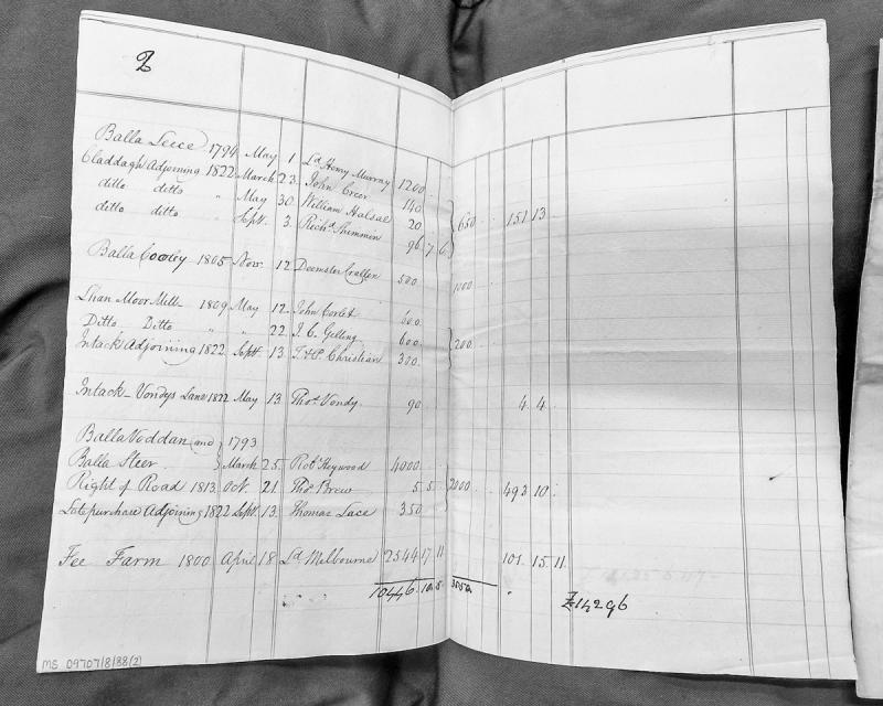
A financial and property abstract listing various parcels of land on the Isle of Man with their valuations, dates of transaction, and associated owners or lessees. The document spans from 1793 to 1822 and includes monetary figures, likely representing rents, fees, or property values. The final totals suggest a comprehensive accounting or rental roll.
Some small and low barrows reportedly centred on SC 29256713 with traces of foundations. The site is partly occupied by a large modern hotel and partly by a golf course. There is now no visible trace of a barrow or of any foundations other than modern ones. There are many small sand mounds on the golf course which may have given rise to the report of barrows. There are no known barrows on the Isle of Man which could be classified as small. No finds were reported when the hotel or the golf course were constructed. The 'small and low barrows' seen by Oswald may be associated with Langness rabbit warren (centred SC 290668) mentioned as 'Conney-warren' in 1687.
A post-medieval lighthouse at Langness, built in 1880 and operated by the Northern Lighthouse Board.
The light is now automated and the ancillary buildings are in private ownership.
The lighthouse and all of the associated complex except for the foghorn are inscribed in the Protected Buildings Register (No. 148).
Langness Lighthouse stands on the low peninsula south-east of Castletown. Engineer Robert Stevenson recommended a light for the site as early as 1801, and in 1811 an unlit tower, later known as the Herring Tower, was built there, but it failed to prevent further wrecks and Trinity House repeatedly rejected calls for a proper lighthouse. Permission was finally granted to the Commissioners of Northern Lighthouses in 1877, and the present lighthouse, engineered by David and Thomas Stevenson, was established in 1880 and first lit that December, showing a white light flashing every five seconds. Its fog signal was discontinued in 1987 and the station was fully automated in 1996.
A small brick-built structure is located on the northwest side of the first islet at Langness Point. It forms the most substantial remains of mine buildings associated with copper extraction in the late 1800s. The foundations of additional structures lie just to the east. None of the structures are marked on the Ordnance Survey 1:2500 First Edition mapping surveyed in 1867, so must post-date this survey.
Copper has been mined from Langness from probably as early as the Bronze Age, since stone tools, of a type used to break up the ore, have been found throughout the area.
Langness is a low, rocky peninsula projecting about 2 km from the island's southern coast near Castletown, ending at Dreswick Point, the southernmost tip of the Isle of Man's main island. The Herring Tower, a stone daymark commissioned by the British Government from architect Thomas Brine and built in 1811 to guide the herring fleet home, still stands near its tip alongside a Victorian lighthouse and the remains of wartime gun batteries. Its treacherous waters have claimed shipping over the centuries, including the wreck of HMS Racehorse on 14 December 1822.
An Iron Age to Early Medieval promontory fort defined by a bank and ditch across the peninsula roughly at right-angles to the coastline. The bank and ditch tend to fade away on the west side but east of the tarmac road it gets larger as it gets to the highest point of the peninsula and down to the cliff edge on the east side. The earthwork faces north at its highest, where the bank is some 8 metres wide and 2 metres high fronted by a ditch 5 metres broad and 0.5 metres deep. East of this the remains of the bank could be interpreted as indicating it was unfinished and there are lengths of berm between the dumps of the bank and the inner edge of the rock-cut ditch. The whole is grass-covered with gorse on it in places. At the highest point it has a modern building on top. A stone wall runs along part of the ditch in its western half and it appears that a stone wall may have run along much of the centre of the bank since there is a robbers trench. At the extreme southwest corner of the peninsula there are 3 lines of bank and rock-cut ditch cutting off the furthest point. The easternmost is short and runs from small natural bay to small inlet and the ditch may follow a natural rock fracture. Above it is a low bank in good condition. At the next break in the rock there is a major rock-cut ditch cutting across the grain of the bedrock, leaving a well-shaped steep-sided causeway, giving an entrance through an in-turned bank. Stones of outer facing are still in position to the north of this entrance. There is a similar slighter defence across the last bit of the peninsula. At the top of a modern path cut into the shillet is an original in-turned entrance with low stone-faced revetment and stones in position on both sides. A cross-dyke cutting across the peninsula is presumably an outwork to the fort on the point.
Defended promontory.
The end of Langness peninsula contains the remains of a promontory fort of unique form amongst other Manx forts such as Cronk ny Merriu, Cass ny Hawin and Close ny Chollagh.
Enclosures and earthworks can be seen on a series of small islets at the south-western tip of the peninsula. The first of these enclosures stands on the promontory attached to the peninsula. Two sea inlets form a natural ditch, and beyond these a defensive bank stands to a height of 1m. At the far end of this promontory the arrangement is repeated, with another natural ditch and a bank defending the landward side of the first islet. The second islet shows no sign of defence, but the third is protected by another bank. Although not particularly high today, it is quite possible that these banks were once augmented with timber palisades.
There is no evidence for ancient buildings on any of the islets, and the small brick-built structure is associated with mine working in the late 1800s. Copper has been extracted from Langness from probably as early as the Bronze Age, since stone tools, of a type used to break up the ore, have been found throughout the area.
Defended promontory.
A bank protects the landward end of a peninsula almost cut off from the mainland by inlets running north and south from this point.
Defended promontory.
The whole of the southern end of Langness is cut off by a substantial bank and ditch which traverses the promontory from east to west.
At its highest the bank is some 8m wide and 2m high fronted by a ditch 5m broad and 0.5m deep. In places the bank is less well defined, which may suggest that it is unfinished.
At the highest point it has a modern building, which served as an explosives store for the nearby 19th century copper mine.
The Langness rabbit warren (centred SC 290668) is mentioned as 'Conney-warren' in 1687. A hotel and golf course have been built across the area of the warren.
This small fragment was found at Larivane Croft in the 1960s. It is a flake from the face of a cross, and bears the remains of a carved male figure in relief. The legs and lower torso of a man wearing a sword survive. On one edge are the incomplete remains of runes, which are illegible.
A financial schedule listing salaries and positions of military and administrative officers stationed across the Isle of Man's five principal fortifications (Rushen, Peel, Douglas, Ramsey, Derby) immediately prior to the 1765 Revestment. Provides evidence of the manpower and cost structure of governance under the Duke of Atholl's rule.
A financial schedule listing military and administrative salaries and posts across Isle of Man's fortified garrisons (Rushen, Peele, Douglas, Ramsey, Derby) immediately prior to the 1765 Revestment. Shows the structure and cost of the Atholl administration's military establishment, totalling £305 5s. Relevant to understanding the institutional framework inherited by Parliament.
Lathom is a locality in Lancashire, England, site of Lathom House, a seat of the Stanley family. The Siege of Lathom House in 1644, during which Charlotte de la Tremouille, Countess of Derby, defended the stronghold against Parliamentary forces, is a celebrated episode in Stanley family history with direct connections to the contemporaneous events on the Isle of Man.
The siege was fought over at a distance as well as on the ground. The royalist leaders at Chester addressed Prince Rupert about it, and the Earl of Derby had to send his own information after them because Rupert had been misinformed. The republicans, for their part, feared the Earl's standing in the county and would not trust their own soldiers if he came among them, and the committee at Manchester addressed him directly.
The house stayed a Stanley seat afterwards. The second wife of the eighth Earl died at Lathom House and was buried at Ormskirk on 16 April 1703, and the family papers of that generation are dated from it.