A 16th-century letter from the Abbot of Furness to Cardinal Wolsey (Lord Legate) regarding the grant of stewardship of Furness monastery. The letter explains delays in responding to previous requests and discusses a prior grant made to the Earl of Derby, seeking clarification on its contents. While not directly about the 1765 Revestment, it provides historical context on administrative relationships and the precedent of English territorial claims over abbeys and dependencies, relevant to understanding the constitutional framework within which the later Revestment occurred.
A letter from the Abbot of Furness to Cardinal Wolsey (Lord Legate) dated 16 July 1530, concerning the grant of stewardship of Furness monastery. The abbot acknowledges Wolsey's request and promises to deliver a formal grant to Edward, third Earl of Derby, once a previous grant made to the late Earl of Derby can be recovered. Relevant to understanding ecclesiastical and noble patronage networks affecting Isle of Man through broader English administrative context.
A 16th-century State Paper reporting a suspicious incident involving a Scottish vessel, Manx crew, and a Scottish pilot who claimed exceptional knowledge of English harbours. The abbot of Furness writes to Thomas Cromwell seeking direction on the custody of the detained Scotsman. Relevant to understanding Isle of Man's medieval maritime context and foreign contacts prior to the Revestment era.
A 1533 letter from Roger Pele, Abbot of Furness, to Thomas Cromwell reporting the arrival of a Scottish vessel with cargo at Ramsey, Isle of Man. The letter describes the crew's attempt to land provisions and a Scottish pilot's boast about his navigation skills in northern waters. The Abbot is holding the Scottish mariner in custody pending the King's instructions. The document provides evidence of early 16th-century maritime activity, smuggling concerns, and royal security interests in the Isle of Man.
Arthur Onslow, Collector of Customs at Liverpool, reports to the Board of Customs on his efforts to suppress smuggling of tea and East India goods at the Isle of Man, 1762–1764. Details enforcement operations, seized vessels, evidentiary challenges, and the practical difficulties of prosecuting smuggling when goods are landed on the island before witnesses arrive. Directly relevant to understanding the smuggling crisis that preceded the 1765 Revestment.
Arthur Onslow, Collector of Customs at Liverpool, reports to the Honourable Board on his enforcement efforts against illegal East India goods (particularly tea) being smuggled through the Isle of Man. He details witness operations, vessel seizures, evidentiary challenges, and his proposal for renewed surveillance. The letter illustrates the practical difficulties in prosecuting smugglers and the constitutional limitations of revenue enforcement in the years before the 1765 Revestment.
Letter from William Christian, Attorney General of Isle of Man, to the Duke of Atholl reporting the discovery of a grave containing weapons (sword and battleaxe) and silver coins found during building works in the parish of Kirk Christ Lezayre in summer 1750. Christian asserts the Duke's legal right to the treasure trove and explains the delay in reporting due to difficulty in securing all items and examining witnesses.
Letter from William Christian, Attorney General of the Isle of Man, to the Duke of Atholl reporting the discovery of a grave containing medieval weapons (sword and battleaxe) and 39 silver coins during building works in the parish of Kirk Christ Lezayre. Christian confirms the items as treasure trove, the Duke's legal property, and explains the delay in reporting due to initial secrecy and difficulty in recovering all items.
Informal letter from Baron Maule to the Duke of Atholl discussing the drafting of an important letter to 'the chief man himself' (possibly a senior government figure), the proposed use of Mr Forrester for negotiations, and the candidacy of Captain John Wood to succeed Governor Cochrane on the Isle of Man. The letter provides insight into the Duke's political networks and the process of appointment to the Manx governorship in the pre-Revestment period.
A letter from Baron Maule to the Duke of Atholl discussing proposed correspondence on Isle of Man matters, the suitability of Mr Forrester for negotiations, and the qualifications of potential candidates (particularly Captain John Wood) to succeed Governor Cochrane. The letter reveals informal networks of influence involving 'two friends' (possibly Lord Mansfield and the Duke of Argyll) advising on Isle of Man affairs before the 1765 Revestment.
Administrative letter from Charles Lutwidge (Collector of Customs at Whitehaven) to Grey Cooper at the Treasury, reporting the destruction of Douglas Pier by storms and noting its strategic importance to naval operations. Directly relevant to post-Revestment Crown management of Isle of Man ports and infrastructure.
A summons letter from the Commissioners for the Advance of Money to Lieut.-Col. Worsley and others, dated 16 July 1652, requesting testimony regarding alleged acts of delinquency by John Sharpeles and William Christian during the Parliamentary reduction of the Isle of Man. This document provides evidence of Commonwealth administrative and legal procedures applied to the island during the English Civil War period.
A summons from the Commissioners for the Advance of Money to Lieut.-Col. Worsley and others, requesting their testimony regarding alleged acts of delinquency by John Sharpeles and William Christian during the Parliamentary reduction of the Isle of Man. The document dates to the Commonwealth period and provides evidence of Parliamentary control mechanisms and judicial proceedings on the island.
Administrative correspondence from Manx customs collectors Mylrea and Quayle to the Duke of Atholl concerning merchant John Taubman's refusal to pay customs duties following the 1765 Revestment. Taubman claims the duties are unjust because he had advanced £300 on credit of harbour revenues now transferred to the Crown, and alleges he was misled by Quayle about the Duke's intention to sell the island. The letter includes Taubman's detailed goods account (rum, tea, brandies, silks, gin) and his conditional offer to pay if his loan is credited against the duties.
Administrative letter from Castletown officials Mylrea and Quayle to the Duke of Atholl concerning cash remittances, duty disputes with Cosnahan and Taubman, Lutwidge's legal case on boon services, and applications for land enclosure and mill licences. Reveals internal management of Atholl's Manx sovereignty and emerging opposition to ducal rights.
Correspondence from Daniel Mylrea (likely a revenue official or factor) to the Duke of Atholl regarding tithe money remitted to the Duke during 1763–1764, with detailed accounting of three payments. The letter also expresses concern about a recent proclamation affecting the Isle of Man and its merchant community, and notes difficulties with the herring fishery. Directly relevant to understanding revenue administration and economic conditions preceding the 1765 Revestment.
Letter from Daniel Mylrea (likely a revenue official or factor in Man) to the Duke of Atholl, reporting on tithe money remittances and expressing concern about a recent proclamation affecting the Isle of Man. Mylrea notes alarm among merchants and difficulties with the herring fishery, suggesting this was written during the period leading up to the 1765 Revestment negotiations.
A letter from Daniel Mylrea, likely a senior administrator on the Isle of Man, to the Duke of Atholl dated 1 August 1764. Mylrea reports having communicated the Duke's reassuring intentions to merchants in Douglas, Peel, and Ramsey, indicating that commercial anxiety about political change has been alleviated. He notes plans for a collection at Douglas with the Comptroller and promises remittance of revenues to the Duke. The letter provides insight into merchant concerns during the period leading up to the 1765 Revestment and the Duke's efforts to maintain commercial confidence.
A letter from Daniel Mylrea (likely a revenue official or administrator in the Isle of Man) to the Duke of Atholl dated 1 August 1764, discussing the positive reception of the Duke's recent communication among Manx merchants. Mylrea reports that merchants are relieved of fears about a 'revolution' (likely political change) and indicates plans for a revenue collection at Douglas. This document is directly relevant to the period immediately preceding the 1765 Revestment negotiations.
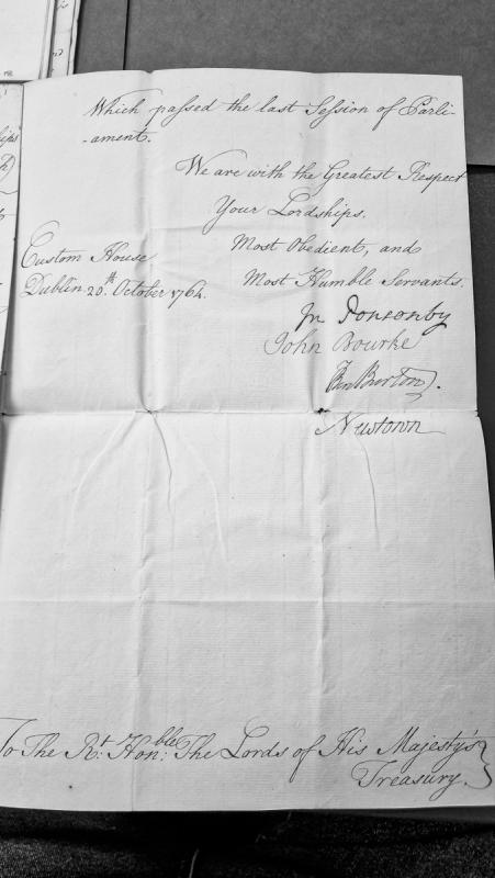
A formal letter from officers at the Dublin Custom House (J. Ponsonby, John Bourke, and Ben Burton) addressed to the Lords of His Majesty's Treasury. The letter references passage through Parliament in the previous session and is written in respectful, formal language typical of 18th-century official correspondence.
A letter from the Duke and Duchess of Atholl to Dan Mylrea, denying rumours that they intend to sell the Isle of Man to the British government. The Duke states no application has been made by government for such a sale. This document is significant as it predates the actual Revestment by less than a year and shows the Duke's public denial of sale intentions just before negotiations began.
A letter dated 18 July 1764 from the Duke and Duchess of Atholl to Dan Mylrea, denying rumours that they intend to sell the Isle of Man to the Crown. The document explicitly states no government application has been received. This is a crucial pre-Revestment source showing the Duke's position before the 1765 parliamentary purchase.
The Duke of Atholl writes to Lord Mansfield (Lord Chief Justice) seeking legal advice on how to respond to pressure from the Treasury and Mr Grenville regarding the sale of Isle of Man sovereignty. Atholl expresses concern about recent orders stationing cutters in Manx harbours, the Treasury's demand for detailed customs accounts, and threats of Parliamentary action. He seeks Mansfield's counsel on whether to delay negotiations, withhold confidential documents from Parliament, or travel to London immediately.
The Duke of Atholl writes to Lord Mansfield (Lord Chief Justice) seeking legal and political advice on how to respond to Treasury demands for detailed accounts of Manx customs and revenues ahead of a potential parliamentary sale of the island. Atholl expresses concern about the precipitous pace of negotiations, the unprecedented stationing of revenue cutters in Manx harbours, and the implied threat of unfavourable legislation if he delays. He claims previous revenue papers were given in confidence and should not be made public.
A 16th-century diplomatic letter from G. Nicolson to Mr. Bowes (likely concerning Scottish/English border security) reporting on attempted Manx landings in Scotland and defensive preparations. The letter mentions instructions from the Earl of Argyle and references failed Manx attempts to land due to Scottish readiness. This provides historical context for early modern Isle of Man activity and Anglo-Scottish relations.