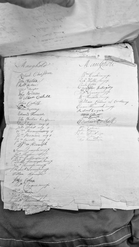
A two-column list of names from the Maughold parish, with many entries marked with '+' (possibly indicating votes, presence, or status). The document appears to be an administrative or court record, though its specific purpose is unclear. Many names are abbreviated and some readings are uncertain.
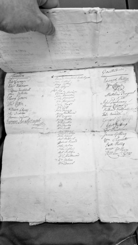
A three-column list of names organized by parish location (Rushen and Castletown). The document appears to be a roster or register of individuals, possibly for administrative, legal, or parochial purposes. Many names have uncertain readings indicated by question marks.
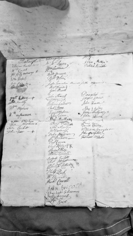
A three-column list of names organized by Manx parishes, likely representing residents, property holders, or participants in an administrative process. The document contains numerous uncertain readings and partial names, suggesting it may be a roster, tax list, or administrative register.
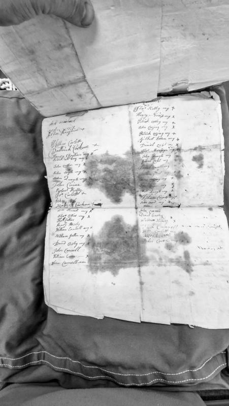
A two-column list of names, predominantly Manx surnames, with various marks ('+', 'my', 'x', '-') indicating signatures, marks, or witness attestations. The document appears to be a record of signatories or participants in a legal or administrative proceeding, though the specific context and date are not provided.
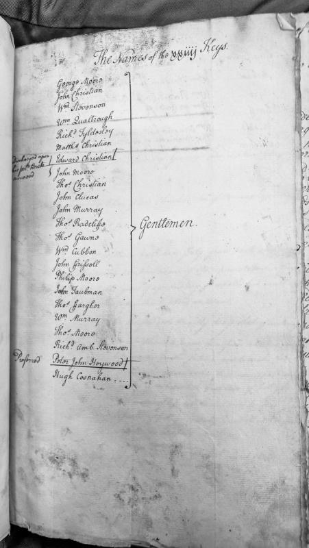
A roster listing the names of 24 members of the House of Keys, the legislative body of the Isle of Man. Marginal annotations indicate that Edward Christian was discharged upon his own request and Peter John Heywood was proposed as a member.
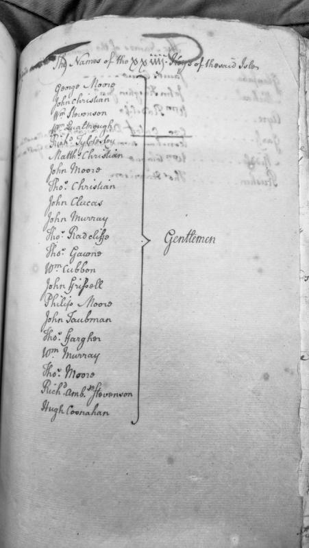
A roster of 21 named members of the House of Keys, the legislative body of the Isle of Man. The document appears to be an administrative list identifying the gentlemen who comprised the Keys during an unspecified period.
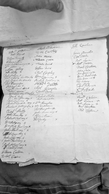
A document containing three columns of names, primarily from the parishes of Kirkby Braddan and Kirkby Conchan on the Isle of Man. Many entries include personal marks (denoted by 'x') or signatures, suggesting this may be a petition, poll list, or administrative register. The presence of marks alongside names indicates inclusion of those unable to write.
Prehistoric promontory forts, alleged sites of.
Dr Gerhard Bersu (1949) speculated that the cliffs overlooking Douglas Bay lent themselves as possible locations of promontory forts of the type occuring elsewhere on the coastline of the Isle of Man, which have been dated to the late prehistoric or Iron Age period. These may readily be identified through reference to the Ordnance Survey 1:2500 First Edition mapping of 1867-8.
Although no trace of defences or artefacts of this period have been observed, he would appear to have been referring to the area towards the north end of the bay between Falcon Cliff and Summerhill, known as Little Switzerland, where the irregular line of cliffs affords at least two opportunities for such defences.
The area is now occupied by lawns and gardens.
The site of a conjectured prehistoric promontory fort. Dr Gerhard Bersu (1949) speculated that the cliffs overlooking Douglas Bay lent themselves as possible locations of promontory forts of the type occuring elsewhere on the coastline of the Isle of Man, which have been dated to the late prehistoric or Iron Age period. These may readily be identified through reference to the Ordnance Survey 1:2500 First Edition mapping published in 1870.
Although no trace of defences or artefacts of this period have been observed, he would appear to have been referring to the area towards the north end of the bay between Falcon Cliff and Summerhill, known as Little Switzerland, where the irregular line of cliffs affords at least two opportunities for such defences. The area is now occupied by lawns and gardens and there is no evidence that such a promontory fort existed.
The site of a conjectured prehistoric promontory fort. Dr Gerhard Bersu (1949) speculated that the cliffs overlooking Douglas Bay lent themselves as possible locations of promontory forts of the type occuring elsewhere on the coastline of the Isle of Man, which have been dated to the late prehistoric or Iron Age period. These may readily be identified through reference to the Ordnance Survey 1:2500 First Edition mapping published in 1870.
Although no trace of defences or artefacts of this period have been observed, he would appear to have been referring to the area towards the north end of the bay between Falcon Cliff and Summerhill, known as Little Switzerland, where the irregular line of cliffs affords at least two opportunities for such defences. The area is now occupied by lawns and gardens and there is no evidence that such a promontory fort existed.
Lancashire port with longstanding military, administrative and commercial connections to the Isle of Man.
Liverpool appears repeatedly in Commonwealth records concerning the conquest of Mann in 1651. Charles Walley of Chester later petitioned the Protector describing his work shipping troops from Chester, Liverpool and the north-Welsh ports and managing expenditure connected with “the reducing the Isle of Man”.
During the political crisis preceding the Parliamentary expedition, Liverpool formed part of the mainland military network watching James Stanley. Prisoners taken during Royalist disturbances in Lancashire were sent to Lancaster Castle and Liverpool, while arms collected from potentially hostile inhabitants were ordered into the port.
Government accounts also record expenditure on messengers travelling to the Isle of Man. In October 1651 the Council instructed the Governor of Liverpool to deal with the two daughters of the Earl of Derby, who were then being held under restraint in the town.
The naval operation against Mann was organised within the same Irish Sea system. Colonel Robert Blake was appointed to command a squadron of twelve vessels intended for the Isle of Man and the eastern coast of Ireland, while ships already operating north of Ireland were ordered to keep a particular watch on the Island.
Liverpool later became one of the principal English ports trading with Mann and one of the main passenger routes between the Island and Britain.
An early medieval cross kept in Lonan church. Manx National Heritage's collections show that Lonan church houses more than one early medieval cross slab individually catalogued by antiquarian P.M.C. Kermode in his corpus "Manx Crosses" (1907) - including, among others, "Lonan Cross Slab (Manx Cross 27)" and "Lonan Cross Slab (Manx Cross 75)" - as well as the separately named "Hairdwillagh Cross Slab (Manx Cross 71)", also kept at the church. Note on ambiguity: it has not been possible to establish from available sources which specific Kermode-numbered cross corresponds to this Historic Environment Record entry, or whether it is intended as a generic record covering the church's cross-slab collection as a whole; this is flagged rather than guessed at.
A broken carved wheel-headed cross-slab kept in Lonan church. It was found circa 1870. It measures 152 centimetres x 55.8 centimetres x 7.6 centimetres.
A fragment of a wheel-headed cross-slab kept in Lonan church. It was found in 1890. It measures 45.7 centimetres x 45.7 centimetres x 12.7 centimetres thick.
The site of an 'ancient' well was discovered by the Reverend Canon Quine at the lower corner of the Glebe, about 130 metres west of Lonan Old Church. The well was triangular in shape and formed of three great blocks of stone set on edge in the bed of a stream. It was likely that it was used for baptism, representing the transition period from the use of living waters to that of the font. It is possible that the cross found here by Canon Quine had originally been set up beside the well.
This rounded boulder was discovered in 1926 built into a wall on the west side of Stoney Road opposite the road to Ballamilgen, Laxey. It bears a deep-set cross with expanding limbs.
This broken slab was found close to a well in one of the glebe fields adjoning the churchyard in 1906. On one face the cross is set within a curved frame, the lower limb projecting just beyond the frame; on the other side the carving simply comprises a cross without a surround.
This small slab was found in the churchyard in 1906. It bears a simple incised cross, made exceptional by short bars which cross the upper and lower limbs. The terminals of the arms are deliberately rounded. A curious semi-circular frame encloses the upper half of the cross, and almost exactly echoes the rounded head of the slab, which seems to have been deliberately shaped.
A fine wheel-headed cross standing in its original position. The base of the cross is inserted through a slot cut in a slab laid flat on the ground. The stone is carved on one face, bearing an equal-limbed cross and a ring with wide borders, set on a short, broad shaft. Circular hollows mark the junction of the arms. The cross and shaft are filled with plait-work, and edged with single or double bead-moulding. The ring which circles the cross is divided into three bands, separated by projecting borders; the inner and outer rings are decorated with further interlace, while the central band contains knots formed from pairs of intertwined chain links.
The upper part of the cross shaft is decorated with four bands of plait-work. The design used on this cross is very similar to that on Manx Cross 72 suggesting that the carver of one may have been familiar with the other, or may have been responsible for both.
This central portion of a small slab is all that remains of a memorial found in the churchyard: substantial parts of both edges have been lost. The stone bears an equal-limbed 'Celtic' cross supported on a ring. The outline of the cross and the ring are edged with a flat moulding. Both are framed within an outer circle, which stands on a narrow shaft.
This broken slab was found in about 1870 at a mound just north of the churchyard. The carving takes the form of a 'Celtic' cross surrounded by a ring. The lower arm of the cross extends below the ring to form a shaft which terminates in a simple flat pedestal. Cross, ring, shaft and pedestal are all bordered by a bead moulding, and the cross is otherwise undecorated.