14 names listed; First World War. 1939-1945. 3 names listed; Second World War. Interlaced Celtic cross made of limestone from Scarlett. There are two small stone pillars either side of the base, from which to hang wreaths.
The memorial was unveiled on Good Friday 1922 by the Captain of the Parish, Mr Joseph Cunningham M.L.C. It was dedicated by the Lord Bishop, who was attended by his son, Mr Bernard Denton-Thompson, as crozier-bearer. Other clergy present were the Vicar (Rev. A. E. Clarke) and the Rev. T. R. Kneale, Rural Dean of Peel. Prayers were said by the Vicar, the Rev. A. H. Whiteley (Congregational), and the Rev. Aaron Smith (Primitive Methodist), and the lesson was read by the Rev. A. T. Burbridge, B.A. (Wesleyan Methodist). The memorial was designed and sculpted by R.W. Creer of Douglas.
Mineral water factory in St Peter's Lane, run by J. Marsdon operating as the Mona Aerated Water Co. and recorded in a reference dating to 1892.
The grid reference is at the midpoint of the street for indicative purposes only.
Mary Hendrick of Douglas, whose appeal set the Governor of the Isle of Man against the Bishop and ended in the Bishop being fined.
She was the wife of John Hendrick, a licensed victualler in the town. On 29 May 1715 she was presented by the churchwardens for having committed adultery with Isaac Allgood of the same place, and on 5 June following she was legally convicted of it by the ecclesiastical court. The censure pronounced on her almost certainly included penance in all the churches. Allgood submitted to his, after some unpleasant delay. She did not: Keble, who compiled the Bishop's life from the diocesan registry, calls her altogether stubborn and rebellious, and records that people who were discontented with the Church's discipline had access to her and prevailed on her to become their instrument for setting the ecclesiastical laws aside.
Her appeal was the point. She appealed from the spiritual court to the Lord of the Isle, and the Governor allowed it. Bishop Wilson held that no such appeal existed. Governor Horne wrote from Castle Rushen on 7 September 1717 defending what he had done: the liberty given to Mary Hendrick to appeal to my Lord Derby, without the Bishop being present, had not been meant to prevent the Spiritual Court from being heard, and on considering the precedents and Lord Derby's own order he was satisfied that although the Lord had prohibited appeals of that kind from the Governor, the officers and the Deemsters, he had not debarred them from himself.
It ran for years and the Bishop lost. At Peeltown on 3 October 1718 the Governor called the Bishop before him to give his reasons why Lord Derby's order had not been complied with in the matter of Mary Hendrick's appeal, and the Bishop's answer was that there was no appeal in that case. J. Rowe, Clerk of the Rolls, signed the minute. A fine of ten pounds was awarded against the Bishop, and the records show it still being dealt with on 7 August 1719. The case was still running in 1721, by which time the Bishop had been to England and back, the Archdeacon Samuel Wattleworth had died on 20 December 1718 aged seventy-two and been buried in Peel Cathedral, and Lord Derby had kept that place vacant for months before inducting Robert Horrobin, Curate of Warrington, on 18 October 1719 while the Bishop was away.
It was not the first collision of the two jurisdictions. Governor Horne had already imprisoned a man who acted under the Bishop's authority, holding him until a book was restored, and that led on to the sharper disputes of which this appeal was the worst.
This building on Hilary Park, historically known as Woodbourne House, now serves as the Freemasons' Hall for the Isle of Man and has been the centre of Manx masonic life since 1925, marking its centenary with a public open day in 2025. Before the Freemasons took it over, the house had earlier been used as a girls' boarding school and as a nursing home. The hall retains features of note to visitors, including a spiral staircase considered significant within freemasonry, stained-glass windows that were hidden away during the Second World War, and artefacts by the Manx Art Nouveau designer Archibald Knox, who was himself a freemason.
A comprehensive finding aid and inventory of UK National Archives documents (SP 48/2 and HO 98/63-82) downloaded from Manx Notebook, covering Crown governance of the Isle of Man following the 1765 Revestment purchase. Lists 70 documents chronologically with file references, dates, senders, and brief summaries of content including correspondence on constitutional matters, civil administration, military affairs, and governance between the Duke of Atholl, Lieutenant Governors, and the Home Office.
A comprehensive index and cataloguing guide listing 70 UK National Archives documents (SP 48/2 and HO 98/63-82) covering Crown governance of the Isle of Man after the 1765 Revestment. Includes document references, dates, file names, and brief descriptions of content. Primary value is as a finding aid for locating original documents across the Home Office and State Papers collections.
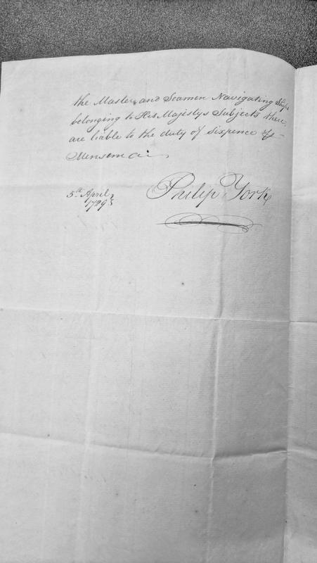
A brief administrative notice regarding the liability of masters and seamen navigating ships belonging to His Majesty's subjects to a duty of sixpence per month. The document is dated 5th April 1799 and signed by Philip York.
A slate slab with a plain cross incised on one face, kept in Maughold Cross House (Manx Cross No 11). It measures 71 centimetres high x 40.6 centimetres, with a maximum width of 31.7 centimetres and is 3.2 centimetres thick.