An extract from Nennius' 9th-century Historia Brittonum, Chapter II, describing Britain's geography, cities, and three principal islands—including Eubonia (Isle of Man). Provided in both English translation and original Latin. Relevant as early medieval context for Isle of Man's political and territorial status.
Excerpt from Nennius' 9th-century Historia Brittonum describing the geography and extent of Great Britain, including identification of three major islands: Inisgueith (Isle of Wight), Eubonia/Manau (Isle of Man), and Orkneys. Provides early medieval nomenclature and political context for the Isle of Man within British geography.
An excerpt from Nennius' 9th-century historical narrative, presented in both English translation and Latin original (Ex Nennio, Cap. II). This passage describes early post-Roman settlement of Britain and Ireland by peoples from Spain, including the settlement of Eubonia (the Isle of Man) by Builc. Included in Manx Society vol. IV (Monumenta de Insula Manniae), this is a foundational historical source for understanding pre-medieval Manx territorial identity and sovereignty.
A bilingual (English/Latin) extract from Nennius' 9th-century Historia Brittonum, republished in Manx Society vol. IV (Monumenta de Insula Manniae). The passage describes early settlements in Britain and Ireland, including the occupation of Eubonia (the Isle of Man) by Builc. Relevant as foundational historical context for understanding pre-medieval Manx history and the island's early political status.
Post medieval gun battery.
Although not part of the protected monument, as it lies under the public highway and adjacent properties, the 'new worke' was an integral part of the modernisation of the castle defences undertaken by the 7th Earl of Derby during the Civil War. It provided improved artillery defences overlooking the harbourmouth, whilst simulateously protecting the outer gate of the barbican.
A watching brief conducted in July 2016 whilst groundworks were being undertaken showed that the north wall facing the harbour and the east wall facing the harbourmouth still survived below ground as substantial masonry structures, constructed using large stones and mortared in clay.
The outer face of the north wall had suffered damage as the result of the construction of a series of small store-rooms accessed at a lower level from the adjacent quayside.
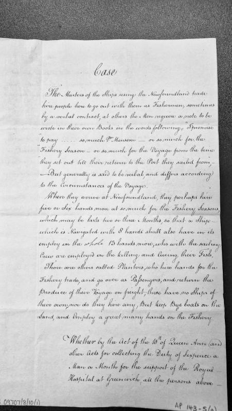
A legal analysis of hiring practices in the Newfoundland fishing trade, describing contractual arrangements for fishermen (both verbal and written), the employment structure aboard fishing vessels, and the distinction between ship masters and planters. The document discusses crew compositions and raises questions about applicability of duties under Queen Anne's Acts.
Niarbyl is a coastal location in the parish of Patrick on the west coast of the Isle of Man. Its name derives from the Manx Gaelic yn arbyl meaning "the tail", referring to the distinctive reef of rocks extending into the Irish Sea, and the site has associations with Manx fishing traditions and folklore.
Letter from Geo. Nicholson and John Cunningham to Mr. Bowes reporting on warnings issued to the Isle of Man regarding defensive preparations against unspecified threat. References correspondence sent via Kyrkowbray to the Captain of the Isle of Man. Document originates from the State Paper Office, Scotland and reflects 16th-century administrative communications concerning Manx governance and security.
Nikkesen's Pool is located in the Awin Ruy ("Ruddy Stream") near its junction with the Glen Roy river in the parish of Lonan. It was said to be the haunt of a water-sprite called the Nikkesen, a creature of the Germanic Nixie tradition who appeared as a horse or a handsome young man, drawing victims - chiefly girls - into his underwater dwelling. By full-moon light, he was said to lead singing and dancing processions of his captives around the meadow below the pool.
Roman coin.
A 4th century Roman coin was found at Noble's Hospital, on Westmorland Road in Douglas in 1951. No further information is available and the grid reference reflects the centre of the hospital site at that time.
The coin is a 3rd brass of Emperor Constans (337-350).
The object is in the collections of Manx National Heritage, accession no. 1954-6671.
Inscription reads as follows: "NVA / Normandy / 1944 / In grateful memory of those / who fought and gave their lives / in the / Normandy Campaign / 1944 / Normandy Veterans Association Isle of Man."
Plaque. Second World War.
Information provided by the Isle of Man Government Preservation of War Memorials Committee.
Image courtesy of Chris Blyth, Isle of Man Photographic Society.
No names listed. Second World War.
Marble plaque bearing the N.V.A. badge. The plaque was affixed to the wall in its current location in November 2004, and dedicated at the Armistice Sunday service. (Letter dated 25 February 2005 signed by E.S. Hannath, Esq., M.B.E, Hon. Secretary of the N.V.A.).
Norris Moore served as High-Bailiff of Douglas on the Isle of Man. In August 1811, he approached Lieutenant Hawkes of HMS Maria directly to ask his intentions regarding impressment of fishermen. Hawkes gave assurances that he would not interfere with the fishery, assurances he subsequently broke.
The era of the sea kingdom. Godred Crovan's conquest at the Battle of Sky Hill in 1079 founded the dynasty that would rule for nearly two centuries. Tynwald formalised governance at a site the Manx people already considered sacred. The 32 Keys served a kingdom that stretched across the Hebrides. Norse and Celtic traditions intertwined — Thorwald's Cross at Kirk Andreas carries Odin on one face and Christ on the other. The diocese of Sodor answered to Trondheim, not Canterbury. Rushen Abbey kept the Chronicles of the Kings of Mann and the Isles. The Treaty of Perth in 1266 ended Norwegian suzerainty.
The North American Manx Association (NAMA) was founded in 1928 in Cleveland, Ohio, to unite people of Manx origin across the United States and Canada. It held annual conventions, published a quarterly bulletin, and by 1950 had achieved a membership of approximately one thousand, with the Manx flag displayed alongside the Stars and Stripes and the Canadian flag at its meetings.
Medieval carved stone cross.
The site was investigated by the Manx Archaeological Survey (1915). A carved stone cross (Manx Cross 24) was recovered, re-used in a lintel grave, on the north side of the keeill.
Medieval chapel and burial ground. The site was investigated by the Manx Archaeological Survey (1915). The chapel is orientated ESE-WNW, and measures 4.7 by 2.8m internally. The walls are 0.7m thick, and stand 0.8m high from the floor, which is now cobbled. The Survey found no trace of an altar, nor windows, though a recess or aumbry was noted in the 'north' wall. The door is in the 'west' gable. The chapel stands within a slightly raised area, which the Survey took to represent a cemetery earlier than the present parish graveyard: lintel graves and unlined inhumations were noted, and two carved stone crosses recovered from separate graves.
Medieval chapel. The site was investigated by the Manx Archaeological Survey (1915).
The chapel is orientated ESE-WNW, and measures 4.7 by 2.8m internally. The walls are 0.7m thick, and stand 0.8m high from the floor, which is now cobbled. The Survey found no trace of an altar, nor windows, though a recess or aumbry was noted in the 'north' wall. The door is in the 'west' gable.