The site of a post-medieval coastal fort. Two coastal gun batteries were in operation around Ramsey harbour mouth during the French Revolutionary Wars (1792-1802) and the Napoleonic Wars (1803-1816). To the south of the river mouth, a gun battery was constructed in 1793 and was later replaced in 1816 by a two-gun barbette, described as just to the north of the Harbour Office. A second battery of two guns was established to the north of the rivermouth in 1797 on the Mooragh. Recommendations to move the 1793 and 1797 batteries to more strategic positions were made in 1799, but unless represented by the later construction of the barbette in 1816, no direct action appears to have been taken to meet this requirement.
The site of a post-medieval malthouse in Ramsey, shown on the 1870 1:2500 scale Ordnance Survey map. The building was re-used as cloth factory and stone mason's yard after the malthouse closed. Modern buildings now stand on the site.
The site of a Neolithic settlement based on archaeological finds discovered during building operations about 1884.
'On the brooghs overlooking Ramsey Mooragh, building operations about 1884 disclosed an area, at a depth of from four to six foot below the surface, which was strewn with flint cores from which implements had been made, chips struck off in the fabrication, flakes, knives, scrapers of at least three forms, drills or awls, arrowheads, and a few stone hammers, with great numbers of broken fragments. All the implements where small, for the most part very rudely formed, though some were rather more finely finished. A few are here reproduced from drawings by Mr H. Walkey of examples found by him at Ramsey. Three burial places were met with in this area, with fragments of decomposed bones in rude cists also broken pottery and ashes with traces of calcined and decomposed bone. Some of these remains may possibly have been of Bronze Age date, the platform having been apparently occupied for a lengthy period'.
A surface scatter of Mesolithic flints was also revealed by erosion of glacial deposits on the coastal cliffs North of Ramsey. These were mainly collected by P.M.C. Kermode and included cores, blades/flakes, scrapers, microliths and micro-burins, now kept in the Manx Museum.
Ramsey Pier or Queen's Pier was designed by Sir John Coode for the Isle of Man Harbour Board and work started in 1882. The pier was officially opened by Bishop Rowley Hill in 1886. The pier closed in 1990 and then underwent extensive restoration from 2015, with the first three sections being reopened in 2021.
The site of Ramsey shipyard, which was established in the 1830s and continues in operation today. Initially occupied in the construction of timber, and later iron, ships, the shipyard was centred around a patent slipway by the time of the 1870 1:2500 scale Ordnance Survey map. This has since been built over, and the business operates from a larger slipway which occupies a former dock just to the west of the old slipway. Other buildings present on the 1870 map have since been replaced by modern workshops.
Lists of 113 names listed on sides of monument and on curb. First World War. Red Dorset sandstone column with Celtic cross at the top.; 4 slate plaques around the base and a further 10 slate plaques facing the column on a sandstone curb that surrounds the main column.
Unveiled on 30 September 1930 by Major General Sir Wm. Fry and dedicated by the Lord Bishop J.D. Thompson. Architect - P.M.C. Kermode Sculptor and builder - Mr T.H. Royston. (Isle of Man Times 2 October 1920, p.7). The names of those commemorated from the Second World War were unveiled on 4 November 1951.
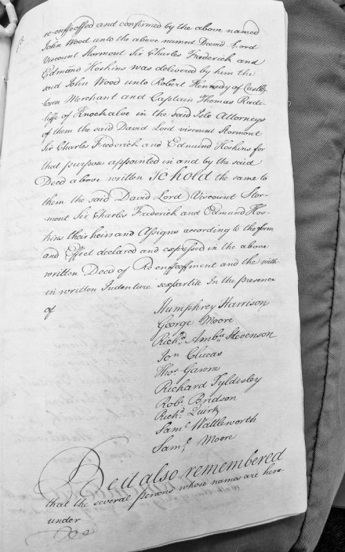
A legal document recording the re-enfeoffment and confirmation of property by John Wood to David Lord Viscount Stormont, Sir Charles Frederick, and Edmund Hoskins. The deed was delivered through attorneys Robert Kennedy and Captain Thomas Radcliffe, with multiple witnesses present on the Isle of Man.
A contemporary newspaper opinion piece published in The Public Advertiser arguing for Crown acquisition of the Isle of Man from the Duke of Atholl. The article details smuggling operations, revenue losses, threats to the East India Company and domestic distillery, and proposes compensation via an annual customs annuity. It references the 1721 Act authorizing Treasury negotiations and draws comparison to the Scottish hereditable jurisdictions purchase.
A contemporary newspaper article from The Public Advertiser (17 August 1754) setting forth arguments for Crown purchase of the Isle of Man from the Duke of Atholl. Focuses on smuggling as the central justification, detailing the scale of illicit trade, revenue losses, impact on the East India Company, and French economic advantage. Directly relevant to understanding pre-Revestment political arguments.
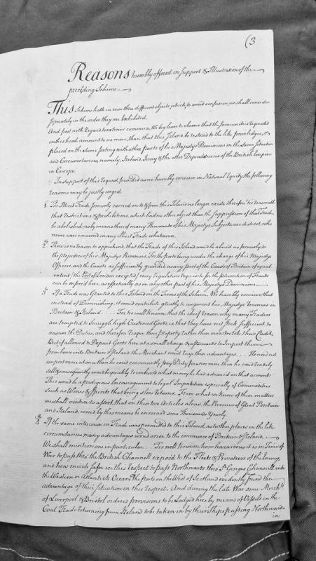
A formal petition presenting reasoned arguments for granting the Isle of Man trade privileges equivalent to other British dependencies such as Ireland and Jersey. The document addresses four main points: the cessation of illicit trade, effective revenue protection, potential increase in British revenues, and strategic commercial advantages during wartime.
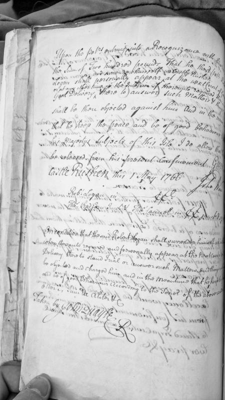
A recognisance document recording Robert Logan's bond of £200 for his release from confinement in Castle Rushen. Logan is bound to appear at the next Court of General Delivery and to keep the peace. Two sureties (Thomas Redfan and Thomas Camel) are named as indictors, each bound in £50.
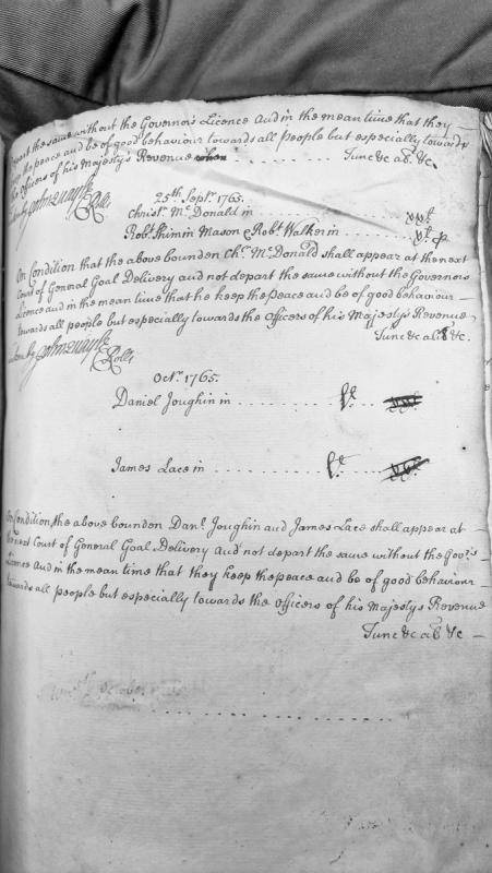
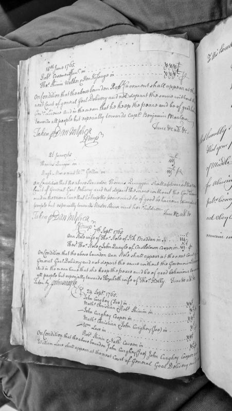
A series of recognisance bonds requiring individuals to appear at the next Court of General Gaol Delivery and keep the peace, with special regard for officers of His Majesty's Revenue. Multiple recognisances are recorded, dated September and October 1765, with sureties named.
A collection of bonds and recognisances binding several individuals to appear at the next Court of General Gaol Delivery and keep the peace. Multiple entries dated June to September 1765 record sureties and conditions for Robert Casement, Thomas Quaggin, Ann Stole, John Curghoy, and William Lace, with specific peace-keeping requirements towards named individuals.
A Manx administrative record documenting complaints about damage to equipment and theft at works at Santan (Ashold, later Newtown), with testimony from witnesses and fines imposed on Henry Crebbin and Jo Callin. The document provides evidence of local governance and property disputes in early 18th-century Mann, with editorial annotations identifying later place-name development and notable burials.
A bilingual (English/Latin) record of oaths of fealty sworn to King Edward I of England by Scottish clergy, nobility, and communities in 1291, including notable figures such as Maria, Queen of Man. The document is part of Monumenta de Insula Manniae (vol. 2) and demonstrates the overlapping jurisdictions and relationships between England, Scotland, and the Isle of Man during the medieval period, relevant to understanding pre-Revestment territorial claims.
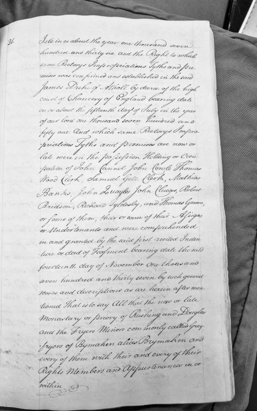
Fragment of a legal document concerning rectory impropriations, tithes and premises in the Isle of Man. References a 1751 Chancery decree confirming rights to James Duke of Atholl, and lists multiple tenants and occupiers of monasteries and friaries including those at Rushen and Douglas.