Prehistoric flint scatter.
A small quantity of worked prehistoric flint was recovered from Sartfield, Jurby by CH Cowley, from the 'Brooghs'.
It is possible that Cowley was drawn to this locality by the burial mound (PRN 0260), unaware that it is probably of medieval origin. The grid reference is for indicative purposes only.
The antiquary Charles Harry Cowley was an avid collector of worked flint and coarse stone artefacts revealed by agricultural activity, mainly on farms located around Peel, and occasionally from further afield. He was active from 1900 until 1943. His entire collection of artefacts, together with a daybook cataloguing his discoveries, was later donated to Manx National Heritage.
The findspot of an early prehistoric flint scatter which included Neolithic flints and a polished stone axehead. The finds included a flint blade, 51 mm long; 2 scrapers, 38 mm and 34 mm in length; 2 flakes each 57 mm long, and a flake measuring 37 mm in length. Cumming refers to a polished stone axehead being found under the peat.
The findspot of a Neolithic flint scatter, found along the eroding coastal cliffs. The finds include late Neolithic flints, round-ended scrapers, flakes and chips and some white gritted Neolithic pottery sherds. Some Mesolithic Heavy-blade flints have also been found here.
The findspot of a Mesolithic tanged Heavy-blade flint point, a flint blade measuring 40 mm overall (collected by G.W. Lamplugh), and a flake with retouched edges.
George William Lamplugh (1859-1926) was a geologist and made the first official geological map of the Isle of Man for the British Geological Survey between 1892 and 1897.
The findspot of an early prehistoric flint scatter, including worked flints, found at the site of the Sartfield tumulus, Jurby (0269.00). The finds included a scraper measuring 45mm by 37mm by 15mm.
The site of a post-medieval horse engine. The circular horsewalk is shown on the 1870 1:2500 scale Ordnance Survey map, located to the western side of farm outbuildings.
Scapa Flow is a body of water in the Orkney Islands, Scotland, that served as the principal base of the Royal Navy's Grand Fleet during both World Wars. Manx people served in the Royal Navy and other services at Scapa Flow, and the Island's maritime connections extended to this strategically vital anchorage.
During groundworks associating with the construction of the small reservoir which once prvided water for Castletown, a burial mound was discovered from which a Neolithic pottery sherd of Ronaldsway type was recovered.
The precise location of the discovery is not known, but as most of the footprint of the reservoir lies in the historic parish of Rushen, the find has been located to this parish rather than Arbory.
The Ordnance Survey 1:2500 large-scale mapping published in 1870 shows a large burial mound at the grid reference provided. A Neolithic stone axehead, of GRoup VI Langdale type, was found in the tumulus and is now in the Manx Museum collections. The mound was described as 'razed' by 1930, and is today completely ploughed down.
The place-name Le Mod, or Ny Mod, derived from the same root as 'moot', or meeting, used to be attached to the mound.
The remains of burial ground have been recorded here, about 620 yards southeast of Keeill Pharlane, within the Treen of Scarclowte (Scarlet). The keeill has long since vanished, but a grass-covered, roughly circular enclosure with internal measurements of 31.0m x 27.0m survives. It is defined by by a grass-covered bank with an average width of 4.0m and an average height of 0.4m. There is no trace of any internal building.
No early investigation appears to have been made except being 'pointed out' on an NHAS visit in 1913. The site was visited by J.R. Bruce on many occasions up to 1966. The burial-ground enclosure could be best traced in low evening light, standing up to 0.45 metres above the general ground level but nothing could be seen of the keeill-site.
Traces of a relict field system of possible prehistoric or early medieval date have been noted here. When recorded the land was cultivated and quite flat. Further fragments of the same field system were reported along the cliff edge to the south and south-east and back towards Scarlett Point. All these fragments lie outside the stone walls which belong to a phase of enclosure of circa 1870. The relict features only exist on the rough ground of the headland and in the one field containing the 'site of Keeill Scarlett Burial Ground.
The remains of burial ground have been recorded here, about 620 yards southeast of Keeill Pharlane, within the Treen of Scarclowte (Scarlett). The keeill has long since vanished, but a grass-covered, roughly circular enclosure with internal measurements of 31.0m x 27.0m survives. It is defined by by a grass-covered bank with an average width of 4.0m and an average height of 0.4m. There is no trace of any internal building.
No early investigation appears to have been made except being 'pointed out' on an NHAS visit in 1913. The site was visited by J.R. Bruce on many occasions up to 1966. The burial-ground enclosure could be best traced in low evening light, standing up to 0.45 metres above the general ground level but nothing could be seen of the keeill-site.
A large, prostrate stone, partly embedded in turf, is shown on Ordnance Survey 1:10560 scale map of 1868. It was raised and inspected by Mr Leighton Stowell and J.R. Bruce in 1966 but no artificial markings were observed. Evidently a stone with markings of 'circles and a sort of zig-zag' were seen by Stowell in the area, circa 1916. An isolated boulder also marked on Ordnance Survey 1:10560 scale map of 1868 and on the Ordnance Survey 1:2500 scale map of 1868 at SC 25096650) was also devoid of artificial markings.
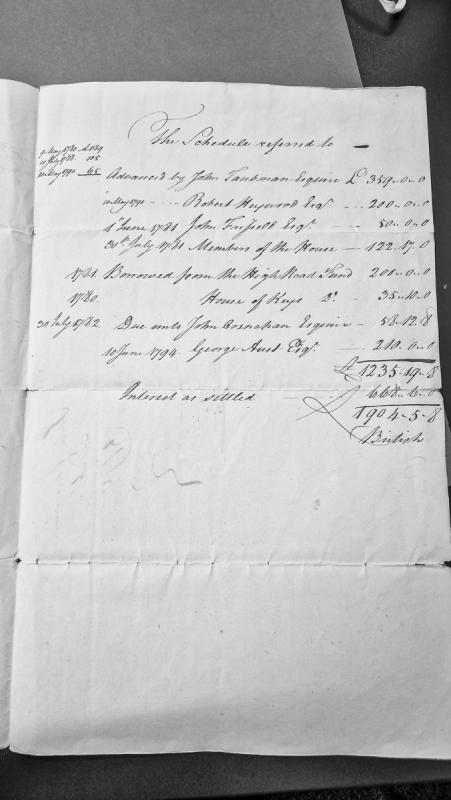
A financial schedule documenting advances made by various esquires and entities to what appears to be a Manx institution or project between 1780-1794. The document lists individual loans, borrowings from the High Road Fund and House of Keys, calculates accumulated interest, and provides a total sum of £1904-5-8.
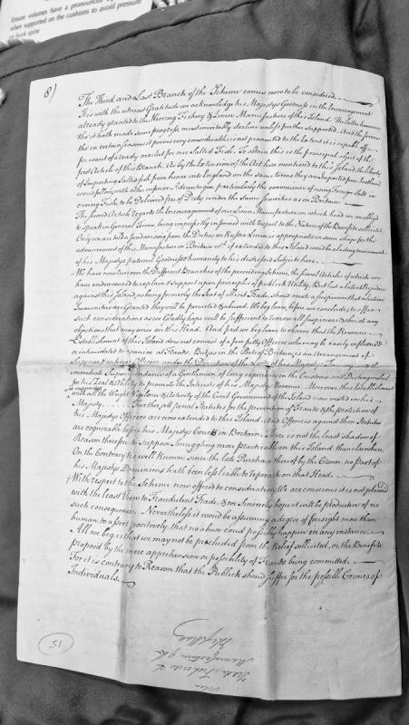
This document presents the third and final branch of a scheme to encourage herring fishery and linen manufacture on the Isle of Man. It argues for extending English trade privileges to Manx-produced salted fish and for funding Manx linen manufacture through duties on Russian linen. The document addresses concerns about the island's historical reputation for smuggling by detailing revenue establishment safeguards and legal protections now in place.
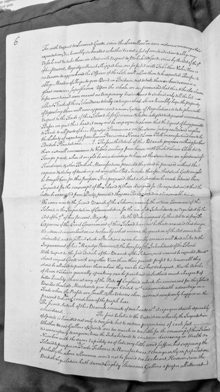
A detailed legal and commercial memorandum proposing reforms to the trade regulations of the Isle of Man. The document addresses restrictions on licensed and prohibited goods, export of provisions and manufactures, and the regulation of interior commerce through duties and import restrictions, arguing for modifications to existing acts to improve both the king's revenue and the islanders' circumstances.