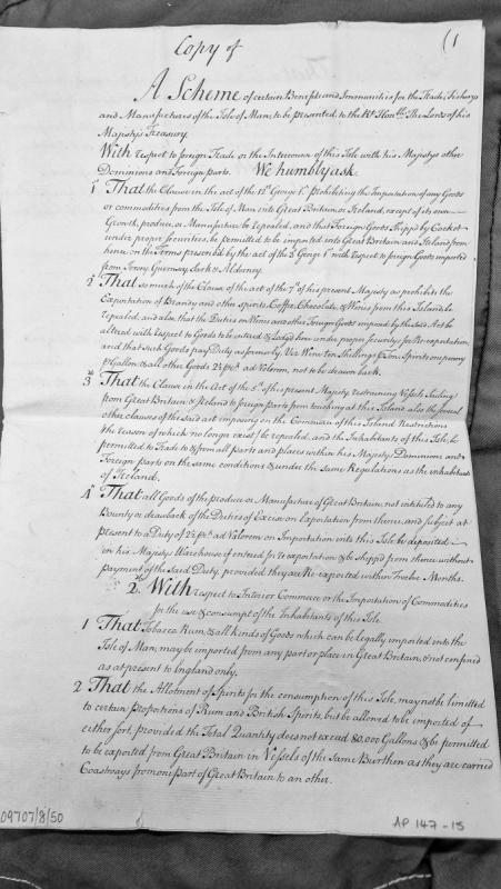
A petition to the Lords of His Majesty's Treasury seeking commercial privileges for the Isle of Man, including repeal of restrictive clauses in various acts of Parliament. The document outlines desired reforms to foreign trade regulations, re-exportation terms, and interior commerce, requesting parity with Channel Islands and Ireland.
Undated standing stone and post medieval ridge and furrow.
The boulder stands 0.9m high with sides of 0.8 and 0.6 m respectively. The surrounding land has been noted for the survival of ridge and furrow and this is still evident running WSW-ENE parallel with the field boundary to the SE.
The stone is not particularly prominent as a landscape feature, and does not appear to mark an existing or lost boundary.
It is noteworthy that the stone is not recorded on the Ordnance Survey 1:2500 First Edition mapping of 1868.
Undated standing stone.
This boulder stands 0.9m high with sides of 0.8 and 0.6 m respectively. The stone is not particularly prominent as a landscape feature, and does not appear to mark an existing or lost boundary.
It is noteworthy that the stone is not recorded on the Ordnance Survey 1:2500 First Edition mapping of 1868.
Neolithic pottery.
A prehistoric urn was uncovered during routine agricultural ploughing on 26th May 1955. The discovery was reported to JR Bruce of the Manx Museum and the site investigated the following day.
The urn proved to be a round-based Neolithic pot of the Ronaldsway type, and had been buried wedged between rough slabs of the local stone. The farm workers who discovered the site reported that the pot had been covered by one or two slabs, and that when these were initially disturbed the pot appeared to be empty.
The urn had been perforated by stones from below and partially compressed by a slab to one side, and was recovered in several pieces. Several detached sherds were recovered from a midden lying just to the north of the findspot, where they had been placed by one of the farmworkers the day before.
The excavation report suggests that the slabs around the pot were not part of a deliberate structure, but were instead a natural occurrence in what was otherwise a noticeably stoney field. Nevertheless, together with the covering slabs they appear to have formed a structure which was effective in preventing soil from entering the mouth of the vessel, which was empty.
A brief handwritten account of the discovery and excavation was prepared by Bruce, along with a set of photographs, which together allow the findspot to be quite accurately located. The site lies on a slight eminence in a sloping field with a south-easterly aspect, which Bruce noted was locally referred to as 'the Cronk Field', perhaps alluding to the former presence of a mound.
The urn was donated by the landowner and is now in the Manx National Heritage collections, accession no. 1983-0209.
Modern watermill and associated water management.
The Ordnance Survey 1:2500 First Edition mapping of 1868 shows a corn mill at this location. The mill is fed via a short leat from two millponds which lie immediately to the north.
Planning approval has been given to convert the mill for domestic use.
Modern watermill.
The Ordnance Survey 1:2500 First Edition mapping of 1868 shows a corn mill at this location.
The mill has been converted for domestic use.
Modern millpond.
The Ordnance Survey 1:2500 First Edition mapping of 1868 shows a millpond at this location. Together with a second millpond to the north, these provided waterpower to a corn mill located a short distance to the south.
The millpond is quarried from bedrock but is now drained.
Modern millpond.
The Ordnance Survey 1:2500 First Edition mapping of 1868 shows a millpond at this location. Together with a second millpond to the south, these provided waterpower to a corn mill located a short distance to the south.
The millpond is retained by a masonry dam along its south side and still contains water, although it now only covers approximately 60% of the area recorded by the 1868 survey.
Post medieval ridge and furrow.
The land surrounding the standing stone is notable for the survival of ridge and furrow and this is still clearly evident running WSW-ENE parallel with the field boundary to the SE.
Worked flints, including flakes and scrapers, of indeterminate late Mesolithic or Neolithic type, were found at School Hill by Canon Quine c.1919.
The name School Hill was centred at the grid reference provided on maps pre-dating the residential development that has now occurred over the site.
Scotland has had a close and complex relationship with the Isle of Man throughout history. The Norse Kingdom of Mann and the Isles was ceded to Scotland by the Treaty of Perth in 1266, and the Scottish Crown held sovereignty over the Island until the English took control in the fourteenth century. The Murray Dukes of Atholl, who held the Lordship from 1736, were a Scottish family.
After the Treaty of Perth, the Island passed between Scottish and English claimants. Alexander III of Scotland, Edward I of England, Robert the Bruce — overlords changed but Tynwald continued to meet. Edward III's 1333 renunciation formally recognised Mann as an independent kingdom. William le Scrope was inaugurated at Tynwald in 1393 and executed six years later. Henry IV claimed the Island by right of conquest. The Percy grant of 1399 and the Stanley grant of 1405 brought the dynasty that would hold the Island for three and a half centuries.
Official report from the Scottish Customs Commissioners to the Lords Commissioners of the Treasury detailing the extent and methods of the smuggling trade between the Isle of Man and Scotland. Documents the types of goods smuggled, Manx import duties, smuggling techniques, and a violent incident at Old Kirk involving revenue officers. Directly relevant to understanding the smuggling crisis that precipitated the 1765 Revestment.
A detailed report from the Scottish Customs Commissioners to the Lords of the Treasury documenting the smuggling trade between the Isle of Man and Scotland. It describes smuggling methods, goods trafficked (spirits, tea, spices, silks, prohibited items), the duties charged by the Isle of Man proprietor, and a violent incident at Old Kirk involving revenue officers and a mob. This document directly evidences the smuggling crisis that prompted the 1765 Revestment.
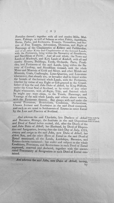
A Scottish legal document detailing the disposition and entailment of extensive lands, lordships, baronies and estates belonging to the Duke of Atholl. The document describes properties within Perthshire including Strathearn, Cardeny, and various other locations, along with rights to mills, fishings, mines, and ecclesiastical patronage. It references previous deeds of disposition from 1775 involving Charlotte, late Duchess of Atholl.
A report from George Nicolson in Edinburgh to the Scottish Privy Council regarding Spanish invasion threats to England and Scotland, with specific mention of the Isle of Man as a target for Spanish landing. The document discusses treasonous activity, fortification preparations, and security measures including imprisonment of Catholic suspects. While predating the Revestment by 174 years, it provides historical context on strategic importance of the Isle of Man and its vulnerability to foreign invasion.
The site of a post-medieval corn mill, shown on the 1869 1:2500 scale Ordnance Survey map. It was powered by water supplied by a mill leat from the south which fed a large, dammed mill pond. The mill stood to the north of the pond and the mill race flowed past the mill and continued northwards, returning the water to the stream.
The site of a post-medieval corn mill, shown on the 1869 1:2500 scale Ordnance Survey map. It was powered by water supplied by a mill leat from the south which fed a large, dammed mill pond. A dam formed the eastern end of the pond, with the mill race entering the pond from the south and exiting to the north. Two further dammed ponds are shown on the 1870 map to the northeast.
The site of a post-medieval corn mill, shown on the 1869 1:2500 scale Ordnance Survey map. It was powered by water supplied by a mill leat from the south which fed a large, dammed mill pond. A dam formed the eastern end of the pond, with the mill race entering the pond from the south and exiting to the north. Two further dammed ponds are shown on the 1870 map to the northeast.
Modern horsewalk.
The Ordnance Survey First Edition 1:2500 map of 1868 shows a horsewalk at this location.
This was a covered structure and it still survives.
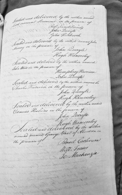
A formal document recording the sealing and delivery of an instrument by six named parties (Lord Viscount Stormont, John Murray, John Wood, Sir Charles Frederick, Edmond Hoskins, and George Earl of Aberdeen) in the presence of specified witnesses. The document appears to be a multi-party bond or recognisance with attestation clauses.