A series of linked planning documents and analytical notes for Part III of a monograph on the 1765 Isle of Man Revestment. The text outlines a forensic framework connecting the Revestment to the American Revolution by arguing that the Tea Act of 1773 and Coercive Acts of 1774 applied the same 'landing = sovereignty' doctrine and 'Company-State' extraction logic first tested on the Isle of Man. Includes proposed chapter structures (16–20), thematic pillars, research priorities, and analysis of how Benjamin Franklin and other colonial leaders recognized the Manx precedent as a warning.
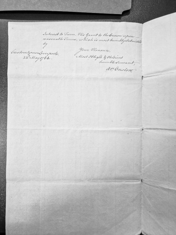
A formal submission letter from the Custom House in Liverpool dated May 23rd, 1764, regarding interest in a farm and a proposed grant to the Crown on reasonable terms. The document appears to be official correspondence relating to colonial or trade administration.
An account of subsistence payments made to customs officers and boatmen sent from Carlisle and Whitehaven to the Isle of Man by Charles Lutwidge following the 1765 Parliamentary Act to suppress illicit trade. The document details individual officer wages, daily rates (2s 6d), and ancillary costs including victualling and expresses, totalling £907 4s 3½d. It directly evidences the Treasury's operational expenditure on customs enforcement immediately after the Revestment Act.
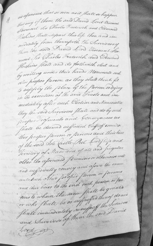
A legal document detailing the succession procedure for trustees (David Lord Viscount Stormont, Sir Charles Frederick, and Edmond Hoskins) responsible for the Isle of Man, Peel Castle, and associated territories. Upon the death of any trustee, the survivors are to elect and nominate a replacement, with property to be conveyed through proper legal instruments to maintain the trust.
Medieval burial ground.
The site was investigated by the Manx Archaeological Survey in 1918.
The Survey uncovered a total of thirteen graves, five of which were partially overlain by the chapel, indicating that the graveyard was established before the chapel was built. The full extent of the graveyard cannot now be traced on the surface, though the area now enclosed by the protective fence is slightly raised.
A cross slab numbered as Manx Slab No 62 (35). The Sulbrick Cross is inscribed in relief and bears a cross of Latin form. It measures 136cm high with a maximum width of 57cm and a minimum width of 40.5cm. It is 5cm thick. For site see PRN 0753.00.
Medieval carved stone cross.
Manx Cross 62 is assumed to have come from this site, as there is no other known keeill of burial ground in the vicinity. For a time the stone stood at Ballacorris (some 600m to the south) before being moved to the parish church.
The findspot of a pre-9th century cross-slab, which is now kept at Santon parish church. The slab measures 137 centimetres x 55.9 centimetres x 10 centimetres thick. It has a Latin cross inscribed on one face, measuring 94 centimetres x 35.6 centimetres. It was Manx Cross number No. 35 (No. 62). The findspot is marshy and scrub covered. There was no visible trace of antiquity or sign of a grave.
This large tapering slab was for a time at Ballacorris before being moved to the parish church. The nearest known keeill and burial ground is that at Sulbrick (IOMHER 0752.00), 600m to the north. It bears a simple outline cross in relief on one face. The edge of the cross is picked out by an incised line, and lower limb is extended so that the cross fills the full length of the stone.
Medieval chapel and burial ground. The keeill is orientated ENE-WSW, and measures internally 5.3 by 2.5m. The walls are 1m thick and survive to a height of up to 1.2m above the original floor level. The walls have the appearence of drystone construction but are bound together with clay mortar and topped with turf. Boulders and surface stones were used and the irregular coursing may have encouraged the partial collapse of the 'east' wall to the extent that the Manx Archaeological Survey of 1918 recorded that the outer face of the wall appeared to be absent. The outer face of all four walls was found to be partially obscured by collapsed masonry.
The doorway is located in the 'west' gable, and the Survey suggested that traces of a window cill survived at the east end of the 'south' wall. The collapsed condition of the 'east' wall as found was thought to preclude the survival of evidence for a window in the gable.
The floor was intermittently paved, mainly near the entrance, and the subrectangular base of the altar could be traced, with maximum dimensions of 1.3 by 0.75m, standing to a maximum height of 0.6m. The front of the altar foundations was marked by a slab of granite, in front of which was found a larger slab which was thought to represent the top of the altar table. This stone was later investigated in 1937 and proved to have cup marks on the underside, suggesting an earlier, prehistoric, use. The stone is now stored by the Manx Museum.
The Survey uncovered a total of thirteen graves, five of which were partially overlain by the chapel, indicating that the graveyard was established before the chapel was built. The full extent of the graveyard cannot now be traced on the surface, though the area now enclosed by the protective fence is slightly raised.
Manx Cross 62 is assumed to have come from this site, on the basis that no other chapel and burial ground are known in the vicinity.
Medieval chapel. The site was investigated by the Manx Archaeological Survey in 1918.
The keeill is orientated ENE-WSW, and measures internally 5.3 by 2.5m. The walls are 1m thick and survive to a height of up to 1.2m above the original floor level. The walls have the appearence of drystone construction but are bound together with clay mortar and topped with turf. Boulders and surface stones were used and the irregular coursing may have encouraged the partial collapse of the 'east' wall to the extent that the Survey recorded that the outer face of the wall appeared to be absent. The outer face of all four walls was found to be partially obscured by collapsed masonry.
The doorway is located in the 'west' gable, and the Survey suggested that traces of a window cill survived at the east end of the 'south' wall. The collapsed condition of the 'east' wall as found was thought to preclude the survival of evidence for a window in the gable.
The floor was intermittently paved, mainly near the entrance, and the subrectangular base of the altar could be traced, with maximum dimensions of 1.3 by 0.75m, standing to a maximum height of 0.6m. The front of the altar foundations was marked by a slab of granite, in front of which was found a larger slab which was thought to represent the fallen top of the altar table.
The site of the burial ground associated with an early medieval keeill or chapel which would have been in use between circa AD500 and AD1000. The remains of the keeill was marked by a turf mound when excavated by Kermode, circa 1918. The north and west hedge of the field in which the keeill stood was recessed, and almost certainly marked the line of the enclosure or cemetery. From the eastern corner of the northern hedge, a line of about 35 metres would reach a low ridge, which appeared to be the south fence of the enclosure. The area enclosed did not appear to be definitely marked. A lintel grave and remains of another one were found near the south wall of the keeill, during the excavations.
Prehistoric flint scatter.
A small quantity of worked prehistoric flint was recovered from Sulby Glen by CH Cowley.
No further details concerning the circumstances of the discovery were recorded and the grid reference relates is for indicative purposes only.
The antiquary Charles Harry Cowley was an avid collector of worked flint and coarse stone artefacts revealed by agricultural activity, mainly on farms located around Peel, and occasionally from further afield. He was active from 1900 until 1943. His entire collection of artefacts, together with a daybook cataloguing his discoveries, was later donated to Manx National Heritage.
A minor bridge across the Sulby River in Sulby Glen. It connected a farm to the east of the river to the main roadway to the west. It is still visible on modern aerial photographs.
The site of a large Wesleyan Methodist Chapel situated to the southeast of the junction of the A3 and the A14. A chapel is shown at this location on the 1870 1:2500 scale Ordnance Survey map.
The antiquarian C.H. Cowley, accompanied by a Mr Pickles, collected flints from a number of location in Sulby Glen but the exact locations of the findspots are not known. They collected both Mesolithic Bann or Heavy-blade type flints, including 'missile heads' as well as scrapers of Neolithic Ronaldsway type.
The antiquarian C.H. Cowley, accompanied by a Mr Pickles, collected flints from a number of location in Sulby Glen but the exact locations of the findspots are not known. They collected both Mesolithic Bann or Heavy-blade type flints, including 'missile heads' as well as scrapers of Neolithic Ronaldsway type.
The antiquarian C.H. Cowley, accompanied by a Mr Pickles, collected flints from a number of location in Sulby Glen but the exact locations of the findspots are not known. They collected both Mesolithic Bann or Heavy-blade type flints, including 'missile heads' as well as scrapers of Neolithic Ronaldsway type.
The antiquarian C.H. Cowley, accompanied by a Mr Pickles, collected flints from a number of location in Sulby Glen but the exact locations of the findspots are not known. They collected both Mesolithic Bann or Heavy-blade type flints, including 'missile heads' as well as scrapers of Neolithic Ronaldsway type.
The site of an early medieval keeill or chapel which would have been in use between circa AD500 and AD1000. The remains of the keeill were marked by a turf mound when excavated by Kermode, circa 1918. Little was left of the walling, scarcely more than two courses, but a plan was made. The north and west hedge of the field in which the keeill stood was recessed, and almost certainly marked the line of the enclosure or cemetery. From the eastern corner of the northern hedge, a line of about 35 metres would reach a low ridge, which appeared to be the south fence of the enclosure. The area enclosed did not appear to be definitely marked. A lintel grave and remains of another one were found near the south wall of the keeill, during the excavations.
The chapel itself is orientated east to west and has internal measurements of 7.0 x 3.0 metres. The north wall merges on the exterior side with the surrounding ground, the remaining walls, averaging 1.3 metres wide and 0.3 metres high, are turf covered with some stone exposed. There are vague traces of an entrance in the west. It is situated in an oval enclosure elevated an average of 0.5 metres above the surrounding ground.