The find spot of a flint scatter which consisted of over 25 flakes, blades and cores, and a granite pounder, 105 mm diameter, which was domed with one battered face.
The site of a post-medieval horse engine. The circular horsewalk is shown on the 1870 1:2500 scale Ordnance Survey map, but the area has since been cleared and redeveloped to include a tennis court.
A financial valuation document estimating the annual revenues and capital worth of the Isle of Man in 1764, itemizing duties on imported commodities, land revenues, ecclesiastical income, and civil posts. The document projects potential future revenue increases and calculates total valuation using purchase multiples (40 and 14 years purchase). Directly relevant to understanding the financial basis for the 1765 Revestment negotiations.
A financial valuation document estimating the annual revenue and capital worth of the Isle of Man's sovereignty, including duties on imported commodities, land revenues, ecclesiastical income, and civil posts. The document projects potential increased duties and calculates total valuation at approximately £620,360. This is directly relevant to understanding the financial basis for the Duke of Atholl's negotiations with Parliament in the Revestment transaction.
Medieval burial ground.
The Ordnance Survey First Edition 1:2500 map of 1868 records 'Site of Chapel & Burial Ground' without a marker denoting the location; the wording is centred at SC20867093.
The Manx Archaeological Survey (1968) could find no upstanding traces of the site but viewed an aerial photograph which suggested the presence of a roughly oval enclosure measuring approximately 20 by 10m, centred at the quoted grid reference. Modern aerial photographic survey (Isle of Man Government, 2015) show very faint indications which tend to confirm this.
No firm structural evidence for a keeill has been located, but the presence of white quartz stones noted by the Archaeological Commissioners (1877) may indicate the remains of a cobbled floor, lintel graves, or both.
Graves have been found or reported on several occasions, and the field is still known as the 'Rellick' (Manx, 'rhullick', a burial ground). The discoveries appear to cover a wider area than indicated by the enclosure cropmark.
Modern watermill and associated water management.
The Ordnance Survey 1:2500 First Edition of 1868 shows a corn mill at this location, fed by an 80m leat from a millpond impounding the Surby stream running from the NNE.
The mill is now destroyed, and the site occupied by a bungalow of 1960s / 1970s date. The millpond is silted up and occupied by trees, though the mill leat still survives.
Modern watermill.
The Ordnance Survey 1:2500 First Edition of 1868 shows a corn mill at this location.
The mill is now destroyed, and the site occupied by a bungalow of 1960s / 1970s date.
Modern millpond.
The Ordnance Survey 1:2500 First Edition of 1868 shows a millpond at this location, which feeds a leat leading SSW to a corn mill 80m away.
The millpond is silted up and occupied by trees, though the leat still survives.
Medieval chapel.
The Ordnance Survey First Edition 1:2500 map of 1868 records 'Site of Chapel & Burial Ground' without a marker denoting the location; the wording is centred at SC20867093.
The Manx Archaeological Survey (1968) could find no upstanding traces of the site but viewed an aerial photograph which suggested the presence of a roughly oval enclosure measuring approximately 20 by 10m, centred at the quoted grid reference. Modern aerial photographic survey (Isle of Man Government, 2015) show very faint indications which tend to confirm this.
No firm structural evidence for a keeill has been located, but the presence of white quartz stones noted by the Archaeological Commissioners (1877) may indicate the remains of a cobbled floor, lintel graves, or both.
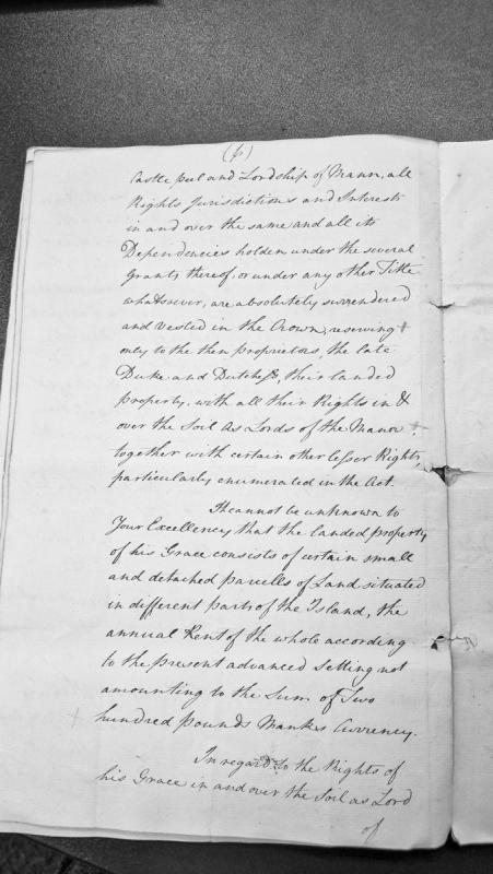
A legal document describing the surrender of Castle Peel and the Lordship of Mann to the Crown, with reserved rights for the then Proprietors (the late Duke and Duchess). It details the landed property holdings consisting of small detached parcels of land throughout the Island with an annual rent of approximately two hundred Pounds Manx Currency, and discusses the rights of his Grace as Lord of the Manor.
A formal deed of surrender by which Roger, Abbot of Furness Abbey in Lancashire, and the convent surrendered all monastery holdings to King Henry VIII, including lands, castles, manors, and rights specifically in the Isle of Man, Yorkshire, Lancashire, and Ireland. The document is bilingual (English and Latin) and demonstrates Crown sovereignty over the Isle of Man in the Tudor period, relevant as background to the constitutional position challenged in the 1765 Revestment.
A formal deed of surrender dated 11 April 1537 whereby the Abbot and Convent of Furness Abbey relinquished their monastery, lands, and possessions into the hands of King Henry VIII. The document explicitly mentions lands and properties in the Isle of Man among other English and Irish holdings. Relevant to understanding the pre-Revestment ecclesiastical and feudal claims over the Isle of Man, and the Crown's consolidation of territorial control during the Dissolution of the Monasteries.
A 1649 survey memorandum documenting rents and properties belonging to the Manor of Furness, including several holdings in the Isle of Man (rectories and lands). The document details scattered properties across Cumberland, Yorkshire, Ireland, and Man, with annual rent amounts. Relevant to understanding pre-Revestment Manx landholding structures and feudal obligations.
A 1649 survey of the Manor of Furness listing rents and properties held outside Lancashire, including several holdings in the Isle of Man (St. Michael and Mahold rectory, Rongstworth, Bubeck Magna, Swynden). The document shows the administrative and fiscal connections between English manorial estates and Manx lands, illustrating pre-Revestment property structures and revenue systems. Relevant to understanding the Duke of Atholl's holdings and the fiscal basis of lordship before 1765.
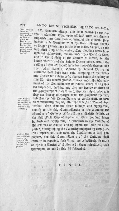
This is an excerpt from legislation (Anno Regni Vicesimo Quarto, Session 2, Section LV) concerning the suspension of inland excise duties and customs duties on rum and spirits imported from British sugar islands and plantations in the West Indies. The act provides for remittance of suspended duties to proprietors for goods in custody of Excise Officers on September 1, 1784, and establishes procedures for certification and repayment of duties by the Commissioners of Customs and Excise.
Peer-reviewed academic paper employing value-chain analysis to reassess the economic importance of the Swedish East India Company's trade between Canton and Europe. Argues that SEIC was a major transnational trader (15% of European Chinese tea imports) and that previous scholarship underestimated its impact on the Swedish economy by ignoring re-exports. Relevant to understanding East India Company operations, tea smuggling networks, and comparative chartered company strategies during the period of the 1765 Revestment.
This is the table of contents and preface from Sir Edward Coke's Fourth Part of the Institutes of the Laws of England, a foundational legal treatise describing the courts and jurisdictions of the English realm. Chapter 69 specifically covers the Isle of Man, its law and jurisdiction. The work is relevant to the Revestment project as it provides the constitutional and legal framework within which the 1765 purchase was effected.
This is the table of contents, prefatory material, and opening chapter from Sir Edward Coke's Fourth Part of the Institutes of the Lawes of England, a foundational legal treatise on the jurisdiction and composition of English courts. Chapter 69 specifically addresses the Isle of Man and its law and jurisdiction. Relevant to the Revestment project as a contemporary legal exposition of Manx constitutional standing before 1765.
A chronological reference table listing the regnal years of English sovereigns from William the Conqueror through Henry II, with explanatory notes on the differences between Historical, Civil, Ecclesiastical, and Legal year calculations. Originally published in Manx Society volumes IV, VII, and IX; republished as part of Monumenta de Insula Manniae. Relevant as contextual/reference material for dating documents in the broader medieval and early modern Manx historical record.
A chronological reference table listing the regnal years of English monarchs from William the Conqueror through Henry II, with detailed explanations of the distinction between Historical and Civil year dating conventions. This reference work provides essential chronological framework for dating documents and events from the medieval and early modern periods relevant to Isle of Man governance and sovereignty.