This pair of semi-detached houses give the appearance of a single two storey cement rendered slate roofed dwelling of distinction. There is a general horizontal expression to the main facade with a subtle string course marking the first floor level. A double molded cornice above the upper floor windows the higher of which marks the parapet wall at roof level. This double cornice also serves to disguise that the seven windows of the upper floor are off centre in spite of the mid point of the building being marked by a raised decorative semi-circular headed window in a classical surround projecting above the cornice. Thus there is no window in either of the lower floors which falls on the center line of the building. This facilitates the handling of the twin entrances each of which have their own projecting vestibules, flat roofed and with decorative mouldings. The additional 'space' at the 'seaward end' of the front elevation is utilised by a larger window which fortunately is not visible from the roadway due to the walls surrounding the property. The other facades are poorly designed, the high wall to the landside having battlements on its upper surface. The main facade of the building has a certain quality to it, but it does not bear close inspection. The prominent siting of the pair at the junction of Bowling Green Road and College Green is somewhat diminished by the triangular walled garden which hides the twin ownership from obvious view. Although it would be a pity to see the property disappear this does not seem to be sufficient grounds for listing the building for preservation. It is not known if there are any significant events or personalities associated with the property which might give reason for further consideration of the matter.
The above assessment was undertaken prior to the existence of Registered Building and Conservation Area legislation on the Isle of Man as a means of judging whether or not the structure was worthy of protection. In the event, the building has not received protection.
Modern smithy.
Former blacksmith's workshop. The adjacent property to the south is still known as the Smithy House. The building is marked on the Ordnance Survey 1:2500 First Edition mapping, although not annotated. An alleyway is shown to the north leading to a rear yard, at the south-west corner of which is a well.
All structures were demolished in July 1983 and a modern dwelling (Smithy Bungalow) now occupies the site.
Modern smithy.
Former blacksmith's workshop.
The building is marked on the Ordnance Survey 1:2500 First Edition mapping, although not annotated. An alleyway is shown to the north leading to a rear yard.
All structures were demolished in July 1983 and a modern dwelling (Smithy Bungalow) now occupies the site.
Modern well.
Site of well associated with blacksmith's workshop. The well is marked on the Ordnance Survey 1:2500 First Edition mapping. It is located at the south-west corner of a rear yard associated with a smithy which fronted onto the highway.
The yard was accessed by way of an alleyway shown to the north of the smithy.
All structures were demolished in July 1983 and a modern dwelling (Smithy Bungalow) now occupies the site.
The native tradition of how the Island received its arms. Before the Christian era, the Island was inhabited by fairies and all business was carried on in a supernatural manner. A blue mist hung continually over the land, preventing mariners from suspecting an island was near. When fishermen, stranded by a storm, struck the first spark of fire on the beach, the fog began to move up the mountainside, closely followed by a revolving object resembling three legs of men joined together at the upper thigh, spinning like the spokes of a wheel. Hence the Arms of the Island. The blue mist was Manannan's cloak of protection in another form.
A comprehensive academic study by J. R. Dickinson examining the maritime commerce of the Isle of Man across nearly two centuries, from early primary product exports (cattle, hides, fish, grain) through the rise of the illicit smuggling trade in the 17th-18th centuries. The paper analyses waterbailiff's customs accounts and port books to document how the island's strategic Irish Sea location enabled it to become a major entrepôt for contraband goods, particularly after increased English tariffs in the late 17th century, culminating in the Crown's purchase of lordship rights in 1765.
A comprehensive academic study of Manx maritime commerce across nearly two centuries, examining customs records, livestock and hide exports, and the evolution of the island's role from modest trading post to smuggling entrepôt. Dickinson contextualizes the running trade within the broader framework of Irish Sea commerce and discusses the constitutional and economic factors leading to the 1765 Revestment.
A scholarly article by J. R. Dickinson examining the maritime commerce of the Isle of Man across nearly two centuries, with particular emphasis on primary products (cattle, hides, fish, grain) in the sixteenth and early seventeenth centuries and the explosive growth of the illicit re-export trade in the late seventeenth and eighteenth centuries. The work analyzes waterbailiff customs accounts and contextualizes Manx trade within Irish Sea regional commerce, addressing the transition from the Stanley lords to the Atholl dukes and culminating in the 1765 Revestment.
A comprehensive academic study by J. R. Dickinson examining Manx maritime commerce across nearly two centuries, with particular emphasis on the evolution from legitimate primary product exports (cattle, hides, fish) to the illicit running trade in the 17th–18th centuries. Uses waterbailiff customs accounts and comparative English/Irish port records to trace trade patterns, duty structures, and the commercial context leading to the 1765 Revestment.
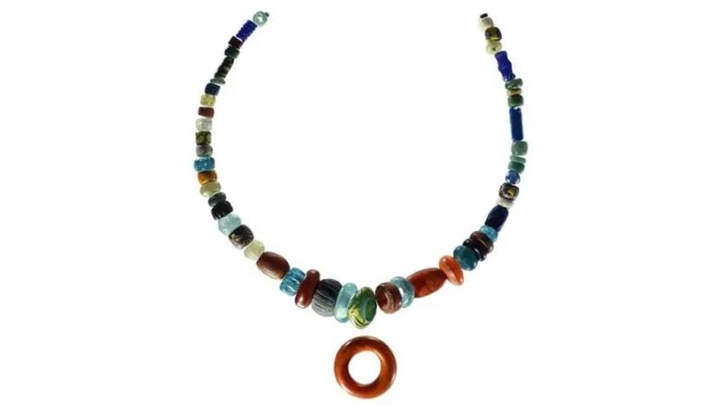
Around 950 AD, a woman was buried in a stone-lined grave on St Patrick’s Isle at Peel. Beside her lay a necklace of glass, amber and jet beads — some already three hundred years old — with an amber ring pendant at its centre. A leather pouch held bronze needles. Three iron knives, a pair of shears, a bone comb, a miniature stone pestle and mortar, and an ammonite fossil were placed around her. Down the length of her body lay a long iron rod, wrapped in textile and feathers from a goose wing. Seeds lay near the rod.
Excavations at Peel Castle between 1982 and 1987, directed by David Freke for Liverpool University, uncovered an extensive early Christian cemetery on St Patrick’s Isle. Within it, seven pagan Norse burials were found — interments that followed Norse custom, placed inside the grounds of a Christian burial site. Among them, this woman’s grave was by far the richest. It is now considered the wealthiest Viking-age female burial in the British and Irish Isles outside Scandinavia.
The iron rod was initially interpreted as a cooking spit, and the burial as that of a high-status head of household. That reading changed when the archaeologist Neil Price examined the object and identified its resemblance to iron staffs found in Norse female graves at Veka in Norway and at Birka in Sweden — graves associated with women who practised seiðr, the Norse tradition of prophecy and magic. The Old Norse word for such a woman was völva, meaning staff-bearer. The staff was the instrument of her craft. If Price is right, the Pagan Lady of Peel was not simply a wealthy woman. She was a seer, a practitioner of the old religion, buried with the tools of her art in the one place on the Island where the worlds of the living and the dead had met for centuries.
Bone chemistry analysis confirmed that she was not born on the Island. She was a traveller who came to Mann and was buried there, carrying with her a necklace assembled from across Europe — beads from Britain, Scandinavia, and the Continent, some of them likely heirlooms, passed down through generations before they reached her.
The burial tells more than one story. A pagan woman, laid to rest with the full apparatus of Norse ritual, inside a Christian cemetery. The community that buried her saw no contradiction, or if they did, they accommodated it. At Kirk Andreas, Thorwald’s Cross carries Odin devoured by Fenrir on one face and Christ triumphant on the other — two religions on the same slab of stone. The Pagan Lady’s grave is the same statement made in earth: the old world and the new, side by side, in the same consecrated ground. The same pattern runs through everything on the Island: the wells in the churchyards, the rushes going up the hill at Midsummer, the fishermen praying to Saint Patrick at the harbour and singing of Manannán on the water.
The necklace is now displayed in the Viking Gallery at the Manx Museum in Douglas.
Norse settlement on the isle is generally accepted to have been founded by Magnus Barefoot circa 1098 who probably built a timber fort or 'Peel' and established a royal residence for the Norse Kings of Man. The latter has been partly evidenced by excavation at the Earl of Derby's Apartments where a burial ground containing an important female burial or 'queen', have been discovered.
This promontory fort originally had a series of three rampart banks and three ditches without inter-space. Only one ditch and bank are now preserved. The fort has a diameter of approximately 760 metres (200 feet). It utilises steep, rock-faced drops to the sea to its northwest, west and southwest sides, with re-entrant inlets to the southeast and northern sides. The narrow strip of land between these two inlets is at the northeast side of the fort, and here a series of banks and ditches were constructed, which are now much eroded and mutilated.
The landward defences are stronger than normal probably because, unlike the majority of this type of promontory fort, the interior is lower than the surrounding ground. It had three banks A, B & C. The outer bank A has ditches on both sides and the inner bank C has a weak almost completely silted up ditch on its outer side. There is a 3.3 m wide causeway across the ditch between A and B. Bank A was partly destroyed to the north by the erection of a hut. It has an upper width of 2.9 m with an inner height of 1.6 m and an outer height of 1.1 m. Its outer ditch is 0.3 m deep from the outer lip. Bank B is 2.9 m wide with an inner height of 1.4 m and an outer height of 1.1 m. Only much ploughed down fragments of bank C remain. Within the grass covered interior no trace of habitation was found.
Pick a parish — your parish, or one you’d like to explore.
Over the summer, build a detailed parish map that shows not just the geography but the history. Mark the keeills. Mark the holy wells. Mark the quarterlands and treens. Mark where the fishing boats launched, where the fairs were held, where the church stands, where the oldest buildings are.
Talk to people. Ask what they know about the place names — Manx place names carry centuries of meaning in a few syllables.
By the end of the summer, you’ll have a map that tells the story of one piece of the island in a way no Ordnance Survey ever has.
The Peveril Hotel is a Neo-classical building which commands a unique location in that Peveril Square is the 'gateway' to Douglas for passengers disembarking from the sea terminal buildings. The structure is predominantly three storeys, all cement rendered (on masonry) the ground floor being expressed as a coursed stone 'plinth' character subordinate to the upper two storeys in which the windows perforate a smooth facade with horizontal moulded decorative courses. The facade treatment is extended around both ends of the building and the main entrance is marked by a columned porch with two storey applied columns through the second and third floors to the triangulated roof projection at the upper cornice. The proportions of the facade could be considered 'elegant' with the vertical windows, in spite of the rather compromised roof elements expressed in similar style. The interior of the building was not inspected. There are obvious major structural problems associated with the facade in subsidence and cracks in the south/front elevation. The external facade of the building is significant to the character of Douglas due to its prominent location, its scale and its proportions.
A fallen fairy, cast out of fairyland for falling in love with a mortal woman. Hairy, ungainly, enormously strong, and slightly tragic. He would gather sheep from the mountain in a single night, cut meadow grass, or move stones that no team of men could shift. He asked nothing in return except to be left alone. When a grateful farmer, meaning kindness, laid out clothes for him, the phynnodderee picked them up one by one, lamented in Manx over each piece, and departed forever. The old people mourned his going: there has not been a merry world since he lost his ground. In the book, the phynnodderee becomes a metaphor for the Revestment itself: the helpful spirit driven away by a gift of clothes, classification destroying the wild thing by trying to domesticate it.
Among the many stories of the Phynnodderee bringing sheep home for his farmer friends, there is one of his having brought home a hare among the flock. When questioned, he explained that the loaghtan beg, the little native sheep, had given him more trouble than all the rest, as it made him run three times round Snaefell before he caught it. The confusion of the hare for a small Loaghtan sheep is comic, but the story also shows the Phynnodderee's earnestness and his connection to the mountain landscape.
A farmer expressed displeasure with the Phynnodderee for not cutting his grass close enough to the ground. The following year the hairy one let the farmer cut it himself, but followed behind stubbing up the roots so fast that the farmer barely escaped having his legs cut off. For years afterwards no one could be found to mow the meadow until a fearless soldier from one of the garrisons took on the task. He began in the centre and cut outward in a circle, keeping one eye on the scythe and the other watching for the Phynnodderee. He finished unmolested. The field, in the parish of Marown near St Trinian's, is still called yn cheeanee rhunt, the Round Meadow.
A gentleman building a house at Tholt-e-Will, at the base of Snaefell, quarried stones on the beach. One immense block of white stone could not be moved despite the united strength of all the men in the parish. Overnight the Phynnodderee carried not only this block but the entire quarry of over a hundred cartloads from the shore to the building site. When the grateful gentleman laid out clothing for him, the Phynnodderee picked up each piece and lamented in Manx: cap for the head, alas poor head; coat for the back, alas poor back. Then he departed forever, mourning: if these be all thine, thine cannot be the merry Glen of Rushen.
The phynnodderee was a fallen fairy — hairy, enormously strong, slightly sad. He’d gather your sheep from the mountain in a single night, cut your meadow grass, or move stones no team of men could shift. He asked nothing in return.
When a grateful farmer laid out clothes for him, the phynnodderee picked them up one by one, lamented over each piece in Manx, and departed forever. The old people mourned: “There has not been a merry world since he lost his ground.”
Go outside — a garden, a park, a field. Imagine the phynnodderee has been helping here all night. What did he do? Build a den or shelter from natural materials, the way he might have worked — using only what you find.
Then leave something at the entrance. Not clothes (you don’t want him to leave). Something else. What would make a lonely fairy feel welcome?
The site of a threshing mill shown as a "T. Mill" on the 1869 1:2500 scale Ordnance Survey map. It is a rectangular stone building in ruinous condition.