Lighthouse. This lighthouse, together with its twin nearby, was built in 1818 for the Northern Lighthouse Board to the designs of Robert Stevenson, one of the Board's most famous engineers.
The two lighthouses worked in tandem, indicating to passing ships if they were in danger of colliding with the Chicken Rock nearly 2km to the south. The Stevenson lighthouses were replaced by a lighthouse on the Chicken Rock itself in 1875, after several difficult years of construction. More recently a modern light, warning of the dangers of the Calf of Man itself rather than the sinister reef to the south, was installed close to the old Stevenson towers in 1967, but this was decommissioned in 2007 as unnecessary in the modern age of satellite-enabled navigation and global positioning. The Chicken light was upgraded at the same time so that its light is visible from a distance of 21 miles.
In common with many of the NLB's installations, each lighthouse was attached to a keeper's house, with adjoining garden and other basic facilities. The buildings are now maintained as nesting sites for birdlife in keeping with the status of the Calf of Man as a nature reserve and bird observatory.
Prehistoric flint scatter.
A single worked prehistoric flint was recovered from Vaaish by CH Cowley, from 'Craine's'.
Two farmsteads called Ballavaish stand within a short distance of each other. It is not clear which of them was occupied by the Craine family at the time Cowley collected his finds. The grid reference relates to a point midway between the two farms for indicative purposes only.
The antiquary Charles Harry Cowley was an avid collector of worked flint and coarse stone artefacts revealed by agricultural activity, mainly on farms located around Peel, and occasionally from further afield. He was active from 1900 until 1943. His entire collection of artefacts, together with a daybook cataloguing his discoveries, was later donated to Manx National Heritage.
C H Cowley recovered flints from the Vaaish on several occasions, including a number of pieces of Neolithic Ronaldsway type.
Garrad (1978) draws specific attention to an unidentified location on the Vaaish, abbreviated to "A'ngh". The name 'Aitnagh' appears elsewhere within Cowley's daybook and may refer to the same locality.
In the absence of further detail, the grid reference provided is centred on the Vaaish for indicative purposes only.
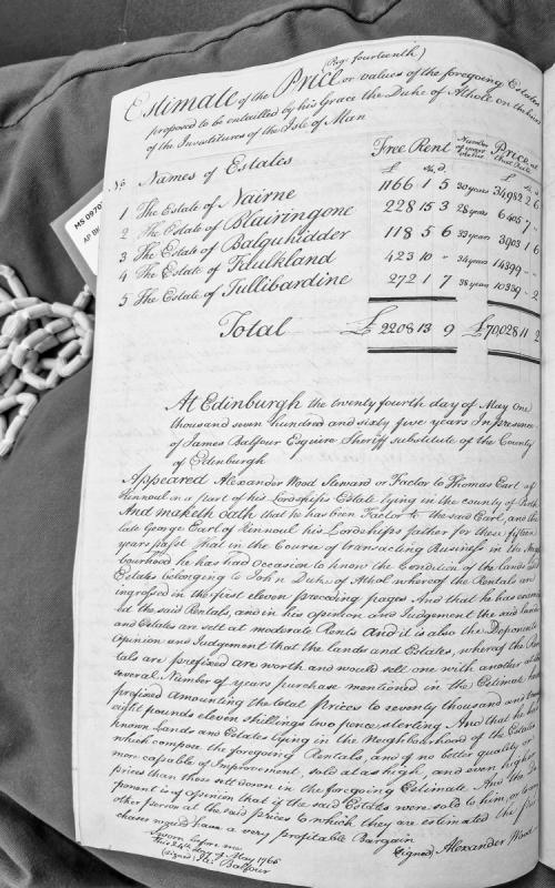
A sworn affidavit by Alexander Wood, factor to the Earl of Kinnoul, attesting to the moderate valuation of lands and estates belonging to John Duke of Athol. Wood provides expert opinion on rental assessments and estimated sale prices totaling £70,028 11s 2d, based on 15 years of experience managing neighboring estates.
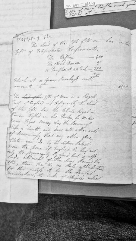
A document describing the ecclesiastical patronage held by the Lord of the Isle of Man, listing the Bishop, Arch Deacon, and 14 parishes with their valuations, totalling 8,400 at 10 years purchase. It also outlines the sovereign and regal powers vested in the Lord of the Isle, including legislative authority, coinage, and judicial powers, comparing the jurisdiction to Scottish precedents.
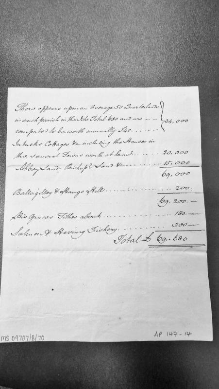
A revenue abstract estimating the annual value of various categories of property and resources on the Isle of Man, including quarterlands, intacks, cottages, abbey lands, bishop's lands, tithes, and fisheries. The total valuation reaches £69,680.
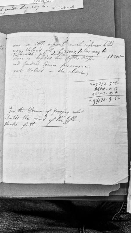
A revenue abstract calculating property valuations, including a castle, house, gardens, and military equipment. The document shows comparative valuation methodology and totals approximately £299,773, with a note regarding the Lord of the Isle's power to impose duties as seen fit.
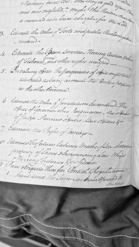
A numbered list of items to be valued and evaluated regarding Manx properties, offices, and rights that were surrendered, likely related to compensation claims or accounting following the transfer of governance. Includes estimates for forts, harbours, fisheries, offices, and jurisdictions.
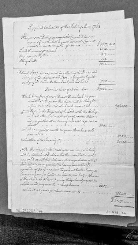
A financial assessment of the Isle of Man's revenue sources and property valuations dated 1764. The document calculates annual revenues from duties, land, tythes and abbey lands, deducts administrative costs, and applies multiplier factors (40 and 14 years purchase) to estimate total valuation of approximately £620,360. It includes a note on anticipated duty increases.
Venice is a historic maritime city in north-eastern Italy. Its connection to the Isle of Man relates to the broader European trading networks in which Manx merchants participated during the early modern period.
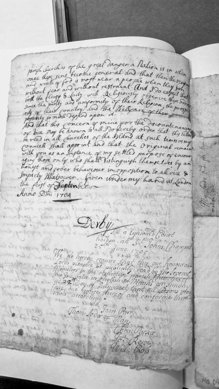
A letter from the Earl of Derby (dated 1 September 1704) addressing the dangers of vice and immorality becoming widespread in society, ordering clergy and laity to observe strict moral standards. The letter was subsequently ordered to be read publicly in all parish churches by the Tynwald Court on 25 June 1705, with instructions for dissemination in both English and Manx.
Victoria Road House is a two storey building is constructed of masonry walls, cement rendered, with a slate covered hipped roof over a basically rectangular plan form. The house is set in a large urban garden with views across Douglas Bay contained by a high cement rendered elevation carried the full two storey height to the eaves whose soffit is decorated with rather widely spaced mouldings. A 'heavy' porch marks the main entrance in advance of the projecting panel and columns. No interior inspection has been carried out. masonry wall only punctuated at the front entrance. The general facade is marred by a poorly detailed garage addition at the front to Victoria Road. There are pilaster columns at the corners and on either side of the entrance projection in the front elevation carried the full two storey height to the eaves whose soffit is decorated with rather widely spaced mouldings. A 'heavy' porch marks the main entrance in advance of the projecting panel and columns. No interior inspection has been carried out. The house appears to be in a poor state of repair. There are no immediately commending aspects to the property and no information of historic significance has been forthcoming.
The Villa Marina complex consists of the octagonal Royal Hall, the arcade and the enclosed gardens and ancilliary buildings. The main entertainment Hall is a plain octagonal brick structure the equivalent of three storeys high with a tiled roof with a small cupola on top. The arcade consists of a long single storey concrete covered walk along a considerable portion of which are small shops paralleling the walkway culminating with a twin row of small shops at right angles to Marina Road at the southern end fronting onto a covered pedestrian arcade. The fenestration of the structure is open sided toward the sea, the roof acting as an elevated promenade from the enclosed gardens the concrete tiled balustrade to which is on top of the twin supporting doric-type columns at pavement level which are periodically reinforced by enlarged rectangular abuttments. The gardens themselves are intensively landscaped and include the provision of recreational and entertainment not facilities for the public. No detailed interior inspection has been made. The complex is important in terms of 'townscape' in that it provides the break in an otherwise continuous succession of tourist accommodation along the promenades of Douglas. Thus there is relief in terms of scale by means of the long single storey covered walk which also enables visual relief by allowing green foliage to be seen on the landward side.
Virginia is a state on the east coast of the United States. William and Jonathan Christian of Maughold emigrated there in 1655, acquiring considerable tracts of land; their descendants included Colonel Robert Christian, a friend of George Washington who served in the Revolutionary War, and John Beverley Christian (1796-1856), an able advocate and jurist educated at William and Mary College.
Record of the Virginia House of Burgesses' nonimportation resolutions adopted after the Governor dissolved the Assembly. The resolutions protest Parliamentary taxation for revenue (particularly the Townshend duties on tea, paper, glass) and establish binding agreements to boycott British manufactures and restrict imports until the offending acts are repealed. This document demonstrates the constitutional crisis in the American colonies and provides comparative context for similar resistance movements.
Virginia House of Burgesses resolutions drafted by Thomas Jefferson rejecting Lord North's February 1775 conciliatory proposal. The document articulates colonial objections to Parliamentary taxation, trade restrictions, and governance interference, asserting the right to self-taxation and self-government. It references the unified position of the Continental Congress and contrasts North's proposal with Lord Chatham's alternative bill.
The promontory lies within the morainic landscape of the northern end of the Isle of Man and is necessarily different from other promontory fortifications which rely on the rocky character of the rest of the Island's coastline.
The site relies for its defence on a large gully to the north and a shallow one to the south, and formerly on the sea to the east, although this is now obscured by land reclamation. Quarrying for sand, gravel and marl has mutilated the cliffline and is likely to have reduced the extent of the promontory.
The site was excavated by Gerhard Bersu in 1946. He found posthole evidence of a series of lightweight timber buildings, with walls of stakes probably woven with withies; no daub or clay was identified. The buildings varied in size from 3.9 m by 7.8 m to 5.4 m by 9.8 m. They were rectilinear, with rounded corners, a central aisle, and unlined cooking pits or hearths. The buildings were superimposed one upon the other with little time lapse between construction. No datable material was found, but by analogy they could be classified as Viking of 9th century onwards. Bersu considered them not to be farmhouses but more likely to be temporary dwellings within a defensive enclosure used by raiders for the period of their raid. The beach and old rivermouth just to the south would tend to strengthen such a suggestion.
Bersu's interpretation as a raiding party's defence is based on rather outdated views of Viking activity in the Irish Sea from the late 8th century onwards, and it would seem more appropriate to see the site as performing a function associated with policing the coastline and perhaps also overseeing beach markets.
The site is now overgrown, but inspection since Bersu's excavation has failed to find traces of the bank surrounding the promontory surveyed by the Ordnance Survey in 1869. Any landward ditch has been damaged or obscured by the later track which led to a 19th century marl pit just to the south. Quarrying would appear to have reduced the extent of the promontory, even since the 1869 Survey.
The Castle Rushen Papers contain a document dated 1627 which records the locations of watch stations around the Isle of Man from which a coastal look-out was kept. The site of the night watch-station for the parish of Lezayre was at 'Hangman's Hill', which is beleived to refer to Vowlan. The name implies that the site was used as a place of execution, much like Hango Hill (record 0031) and Knock Rushen (record 0079) in Malew.
Defended promontory. The site lies within the morainic landscape of the northern end of the Isle of Man and is necessarily different from other promontory fortifications which rely on the rocky character of the rest of the Island's coastline.
The site relies for its defence on a large gully to the north and a shallow one to the south, and formerly on the sea to the east, although this is now obscured by land reclamation. Quarrying for sand, gravel and marl has mutilated the cliffline and is likely to have reduced the extent of the promontory.
The site was excavated by Gerhard Bersu in 1946. He found posthole evidence of a series of lightweight timber buildings, with walls of stakes probably woven with withies; no daub or clay was identified. The buildings varied in size from 3.9 m by 7.8 m to 5.4 m by 9.8 m. They were rectilinear, with rounded corners, a central aisle, and unlined cooking pits or hearths. The buildings were superimposed one upon the other with little time lapse between construction. No datable material was found, but by analogy they could be classified as Viking of 9th century onwards. Bersu considered them not to be farmhouses but more likely to be temporary dwellings within a defensive enclosure used by raiders for the period of their raid. The beach and old rivermouth just to the south would tend to strengthen such a suggestion.
The site is now overgrown, but inspection since Bersu's excavation has failed to find traces of the bank surrounding the promontory surveyed by the Ordnance Survey in 1869. Any landward ditch has been damaged or obscured by the later track which led to a 19th century marl pit just to the south. Quarrying would appear to have reduced the extent of the promontory, even since the 1869 Survey.
The Castle Rushen Papers contain a reference in 1627 to 'Hangmans Hill' as the site of the night watch-station for the parish of Lezayre. The same source later makes reference to the 'Danes fort' in 1719. The coastline of Lezayre is quite short, and this is probably the only location suitable for the Night Watch. It is tempting to see both references as relating to Vowlan, though the latter is perhaps somewhat fanciful. Bersu's interpretation as a raiding party's defence is based on rather outdated views of Viking activity in the Irish Sea from the late 8th century onwards, and it would seem more appropriate to see the site as performing a function associated with policing the coastline and perhaps also overseeing beach markets.
Waldron, writing around the 1720s, recorded the native belief that the first inhabitants of the Island were fairies, and that these little people still had their residence among the Manx. They called them the good people and said they lived in wilds and forests and on mountains, shunning great cities because of the wickedness acted therein. All the houses were blessed where they visited, for they fly vice. Waldron noted that a person would be thought impudently profane who should suffer his family to go to bed without having first set a tub of clean water for these guests to bathe themselves in. If anything happened to be mislaid and found again in an unexpected place, they presently told you a fairy took it and returned it.