Medieval chapel and burial ground. The site lies in a field traditionally known as the 'Chapel field'. The chapel and a small sub-rectangular enclosure surrounding it are left undisturbed at the edge of a cultivated field.
The chapel is orientated east-west, and measures 5.8 by 3.5m internally. The walls vary in thickness between 0.9 and 1.2m, and stand 0.3 to 0.6m high, though at the time they were recorded by the Manx Archaeological Survey in 1918, survived up to a maximum of 1.2m. The north-west corner of the structure is particularly damaged. The walls are faced with stone in irregular courses and the fill in between made up of earth and small stone. A slight indication of the altar against the east wall still survives, though this is only discernible as a rise in the turf. A slight bank of material outside the walls probably comprises material derived from the collapse of the walls.
The surrounding enclosure is roughly 25 by 17m, and is visible as a rise in the ground. The Survey was of the opinion that the enclosure had been cut through by the road to the south, and it would seem likely that it has also been abbreviated by ploughing on the north-east side. The bank defining the enclosure was recorded by the Survey as about 1.2m wide, but in some places was spread as much as 2.4m, and rising in places to a height of 1.3m; it is much reduced now. A number of large stones lying on the surface would appear to have been placed relatively recently, and probably derive from agricultural disturbance in the surrounding field.
There are no recorded burials, but the once substantial nature of the surrounding bank and the raised interior would together seem to imply that the enclosure was once used for this purpose. The localised presence of clay inside the chapel, taken by the Survey to indicate decayed Bronze Age burials predating the Christian use of the site, has since been dismissed as unfired clay daub.
Medieval chapel. The site lies in a field traditionally known as the 'Chapel field'.
The chapel is orientated east-west, and measures 5.8 by 3.5m internally. The walls vary in thickness between 0.9 and 1.2m, and stand 0.3 to 0.6m high, though at the time they were recorded by the Manx Archaeological Survey in 1918, survived up to a maximum of 1.2m. The north-west corner of the structure is particularly damaged. The walls are faced with stone in irregular courses and the fill in between made up of earth and small stone. A slight indication of the altar against the east wall still survives, though this is only discernible as a rise in the turf. A slight bank of material outside the walls probably comprises material derived from the collapse of the walls. Localised deposits of clay inside the chapel, taken by the Survey to indicate decayed Bronze Age burials predating the Christian use of the site, have since been dismissed as unfired clay daub.
An extensive historical survey tracing the Isle of Man from Roman times through the medieval period, covering early nomenclature, Druidic settlement, Scottish immigration, and the succession of ruling dynasties. Includes accounts of key figures (Macao, Goddard Crownan, Magnus) and the transfer of sovereignty to the English crown under Edward I and III, establishing crucial background for understanding pre-Revestment governance structures.
An extract from Campbell's Political Survey covering the ancient and medieval history of the Isle of Man from its earliest mentions by Caesar through the Norman period and establishment of the Montacute claim. Traces the island's successive ruling dynasties (Druidic, Scottish, Norwegian, Goddard Crownan's line) and its relationships with England, Scotland, and Scandinavia, providing historical context for understanding the island's constitutional and territorial status before the 1765 Revestment.
Granite headstone situated within a memorial garden. The headstone is adorned with the emblem of a maple leaf.
It was unveiled on 6 July 2014 by Colonel Marc Bigaoutte RCAF. The memorial was dedicated by the Reverend B. Gulland. It was designed by Ivor Ramsden and built by T.E. Cubbon Ltd, Monumental Masons of Castletown.
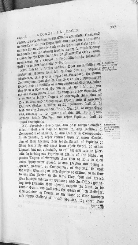
This is an excerpt from Chapter 46 of a statute during the reign of George III, containing clauses XIV and XV regulating the manufacture and sale of distilled spirits. The text establishes maximum strength requirements for spirits sold for home consumption and includes exceptions for spirits of wine under specific conditions.
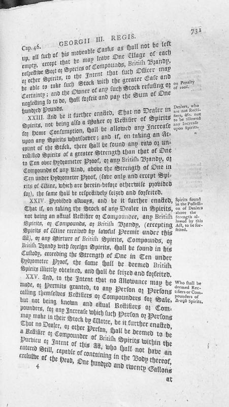
An excerpt from Chapter 46 of legislation under King George III concerning regulations for dealers and rectifiers of spirits. The text details penalties for non-compliance with stock management requirements, restrictions on spirit strength levels for non-rectifier dealers, and definitions of qualified rectifiers and compounders for sale.
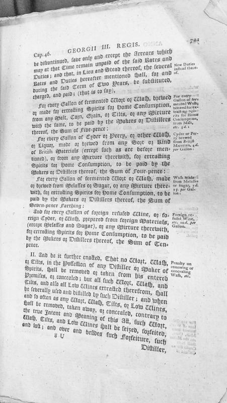
This is an excerpt from legislation (Cap. 46) during the reign of George III establishing new excise duties on various fermented worts, washes, ciders, and spirits produced for home consumption. The document specifies duty rates ranging from 4 pence to 10 pence per gallon depending on the material source, and includes penalties for removal or concealment of materials subject to duty.
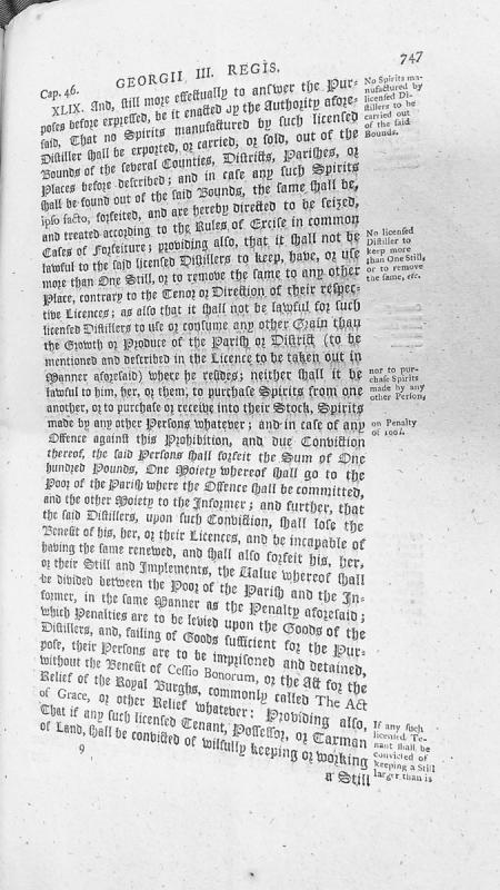
This is an excerpt from a legal statute (Cap. 46, Section XLIX) from the reign of George III regulating licensed distillers. It establishes restrictions on the export and sale of spirits outside specified bounds, limits distillers to a single still, restricts grain sources to local parishes, and prohibits purchasing spirits from other distillers. Violations result in forfeiture of £100, loss of license, and potential imprisonment.
Captain James Thomson reports to Major John Gardiner on a disturbance in Douglas involving soldiers under his command assisting a naval press gang. The letter defends the soldiers' conduct during a confrontation with fishermen who resisted impressment, resulting in two fishermen being wounded. Thomson emphasises his efforts to maintain good relations with the civilian population and clarifies his own non-involvement in the actual impressment.
Captain Dawson, the Crown's own military engineer, had warned London that the smuggling trade had functioned as a kind of non-aggression pact with France: the French left Mann alone because Mann's harbours were useful to French commercial interests. Parliament had destroyed that arrangement and provided nothing adequate in its place. The island that had protected itself through commerce was now defenceless, and its men were fighting someone else's war. The strategic absurdity went deeper — the Isle of Man sat in the middle of the Irish Sea shipping lanes, a natural base for coastal defence. But the harbours were in ruins. The money that might have made the island a strategic asset had been sent to London.
Captain George Dowe commanded the Whitehaven customs sloop Sincerity. In August 1750, he lured Captain Matthias Christian, the Commander at Ramsey, aboard his vessel and presented pistols to his breast, threatening to blow his brains out and to batter his house to the ground. The episode illustrates the violent reality of customs enforcement in the Irish Sea before the Revestment.
James Cook (1728-1779) was a British navigator and explorer renowned for his three voyages of discovery in the Pacific Ocean. His connection to the Isle of Man relates to the broader context of eighteenth-century British naval exploration in which Manx sailors participated.
Captain John Quilliam (1771-1829) was a Manx-born Royal Navy officer who served as first lieutenant aboard HMS Victory at the Battle of Trafalgar in 1805. When the Victory's wheel was shot away during the battle, Quilliam and the master steered the ship from the gun room by tiller, and he is credited with personally repairing the damaged steering gear. He was later elected to the House of Keys and retired to Kirk Michael, where his tombstone describes him as "the uncompromising defender of the rights and privileges of his countrymen."
Captain Matthias Christian served as Commander at Ramsey on the Isle of Man, a member of the prominent Christian family of Milntown in Lezayre. In August 1750, he was lured aboard the Whitehaven customs sloop Sincerity by Captain George Dowe, who presented pistols to his breast and threatened to destroy his house.
Captain Murray served as a customs searcher at Peel, responsible for inspecting incoming vessels for contraband during the period of the Island's smuggling trade.
Official report from Captain James Thomson (2nd Battalion, 6th Regiment) to Major John Gardiner regarding a press gang impressment operation in Douglas harbour on the night of 13-14 August 1811. Thomson defends his soldiers' conduct during an altercation between locals ('Fishermen') and Lieutenant Hawkes's press gang, explaining military assistance provided and use of ball cartridge. Documents civilian resistance to impressment and civil-military tensions on the Isle of Man.
The site of the burial ground of an early medieval keeill or chapel site, which would have been in use between circa AD500 and AD1000. It is shown on the 1870 1:2500 scale Ordnance Survey map.
P.M.C. Kermode recorded the remains at a time when one wall of the keeill remained and formed part of the boundary of the haggard a little to the rear of the farmhouse here. Mr Callow, the owner, allowed Kermode to excavate inside, but no foundations or further remains were discovered. Many lintel graves have been found in the enclosure and a stone which may have been a font is kept in the haggard.
All that remains of this chapel is a turf covered glacis type bank orientated northeast to southwest. It is 10.4 m long and 0.6 m high with several stones exposed. The feature is virtually destroyed and there remains no real trace of walling and no visible trace of the burial ground enclosure.
The lower end of cross shaft carved with zoomorphic interlace (Manx Cross No. 82). It was found in 1894. It measures 25.5 centimetres x 30.5 centimetres x 4 centimetres thick.
This fragment was found at the chapel at Cardle Veg (IOMHER 0597.00) in 1894. It forms the lower portion of the shaft of a cross with an interlace of dog-headed bands. Small spaces outside of the interlace are filled with small C-shaped spirals or 'volutes'.
The site of an early medieval keeill or chapel site, which would have been in use between circa AD500 and AD1000. It is shown on the 1870 1:2500 scale Ordnance Survey map.
P.M.C. Kermode recorded the remains at a time when one wall of the keeill remained and formed part of the boundary of the haggard a little to the rear of the farmhouse. Mr Callow, the owner, allowed Kermode to excavate inside, but no foundations or further remains were discovered. Many lintel graves have been found in the enclosure and a stone which may have been a font is kept in the haggard.
All that remains of this chapel is a turf covered, glacis type bank orientated northeast to southwest. It is 10.4 metres long and 0.6 metres high with several stones exposed. Upon this bank rests the 'font' - a stone with a shallow basin. It is 0.4 metres in diameter and it is 0.1 metres deep. The thickness of the lip is 0.1 metres. The feature is virtually destroyed and there remains no real trace of walling and no visible trace of the burial ground enclosure.
Ships arrived at Douglas from Copenhagen, Amsterdam, Bordeaux, Stockholm, Hamburg, Barcelona, and Cette. Tea came from China via Holland. Brandy came from France. Tobacco came from the American colonies. Silk and cotton came from India. Rum came from the West Indies. Gunpowder for the slave trade passed through a Manx harbour on its way to the Guinea Coast.
Take a blank map of the world and plot every trade route that connected to the Isle of Man. Use different colours for different goods. When you’ve finished, stand back and look at it.
A tiny island in the Irish Sea, connected to everywhere.
Carlisle is a city in Cumberland in north-west England. As the principal town of the county nearest to the Isle of Man on the English side, it was closely connected to the Island's administrative and commercial affairs, particularly during and after the Revestment period when Cumberland-based customs officials such as Charles Lutwidge operated between the two jurisdictions.