Modern courthouse.
The upper level of the gatehouse served as a courthouse until the early 21st century, preserving administrative and judicial functions connected with the castle as the gubernatorial seat, and the surrounding town as the Island's capital until the late 19th century.
Medieval curtain wall.
The castle's defences were gradually strengthened and extended through the 14th century by the development of a curtain wall circuit protecting the keep. Development began with the early construction of the mantlet, and continued in an anticlockwise direction culminating in the development of the outer gatehouse and eventually the barbican. From as early as the third quarter of the 14th century the curtain wall defences included provision of artillery, positioned in turrets.
Post medieval barbican.
The barbican was developed from the 14th through to the 16th century. Its masonry shows a varied development history, complicated by the scars left after the removal of a police station around the turn of the 20th century.
Post medieval counterscarp and glacis.
During the second quarter of the 16th century, protection of the curtain wall against artillery was provided on the east and south sides by the addition of a counterscarp wall faced with a glacis. Now covered in turf, the glacis was originally faced in stone.
Medieval stone castle.
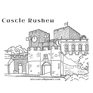
Castle Rushen is widely regarded as one of the most complete medieval fortresses in Europe. It was begun by the Norse kings of Man in the later 12th century, probably by Reginald (1187-1226), though its form was influenced by Anglo-Norman design. It was captured by Robert Bruce during a Scottish raid in 1313 that was intended to frustrate English activity in the Irish Sea, but seems to have undergone repair and significant development soon after.
In 1417 it was the location for a Tynwald assembly and again in 1422 for an assembly held before Sir John Stanley, the new English overlord. At this time it had attained its modern height and a curtain wall had been added. By the 16th century further development had taken place, transforming it into an artillery fortress protected against cannon-fire by an outer glacis.
In the mid 17th century the castle was refortified by James Stanley the 7th Earl of Derby as part of his defence of the Island against Parliamentary forces. In spite of this the castle fell due to a rebellion by the Manx against the Stanley family in 1651 in the face of a threatened siege by Parliamentary forces.
More recently the castle served a more administrative function, acting as the governor's residence and as a prison. In the early 1900s the many late accretions resulting from its development as a prison were removed, restoring it to some of its former glory as a medieval fortress and the seat of kings whose power held sway over the Irish Sea and the Western Isles of Scotland.
Post medieval round tower.
The south and east-facing aspects of the outer glacis were once strengthened at this point by the presence of a substantial tower, now demolished to below ground level as a consequence of road widening.
Post medieval tower.
The approach to the castle from the north was protected from the early 16th century by the construction of an outer artillery tower. Unlike the other outer defensive strongpoints constructed in this period, the Round Tower was not physically connected or incorporated in the glacis.
Castletown is a town in the south of the Isle of Man that served as the Island's capital until 1869. Dominated by Castle Rushen, it was the centre of Manx government and administration under the Lords of Mann and through the early post-Revestment period, and is the location of Bridge House and the Nautical Museum.
Modern harbour breakwater.
The outer breakwater at Castletown was begun in 1844 and completed in 1845, by the Island's Harbour Commissioners. The cost was £2,700, and its construction created the New Basin, sometimes known as the 'dry harbour'.
Its creation was criticised in an offical report published in 1845 as 'unnecessary', and was stated not to have been built in line with the recommendations of engineers or local fishermen and pilots.
The breakwater was extended by 30 yards in 1849, and marked with a masonry beacon. Its total length is 185m.
Modern brewery.
The Ordnance Survey 1:2500 First Edition mapping of 1868 shows a brewery centred at this location. Brewing appears to have been conducted at the site for several decades prior to this.
The brewery complex ceased operation in 1986, and was demolished in readiness for a residential redevelopment which was completed a few years later. The site, and the road alongside, is now known as Brewery Wharf.
Modern brickworks.
Although Bagnio House has been identified by means of an inventory of Castle Rushen made in 1694 as the site of a 17th century brick kiln owned by the Lord of Man, the persistence long after of a field name at Red Gap farm suggests that brickmaking could have continued for some time after this period.
The field was still known in the 1820s as 'the Brickfield', implying that here the clay was dug for brickmaking. The farmstead lay at the grid reference provided, some 600m WNW of Bagnio House. The site has been altered by road-widening.
Modern road bridge.
The modern concrete and steel road bridge carries traffic into the old medieval part of the town.
It stands on the site of several previous bridges, and makes use of the adapted abutments and central pier of its immediate predecessor, which operated as a swing bridge.
Modern bridge.
The modern road bridge and integral footbridge on its downstream side cross the Silver Burn just downstream of the railway bridge.
The bridge carries the modern bypass road (A5) which avoids the centre of the medieval town.
A plaque recording its construction is placed on its westerly end.
This modern footbridge spans the Silver Burn and provides access between Hope Street and Victoria Road.
It is locally known as the Apostles' Bridge, on account of its multiple piers.
Modern footbridge.
This steel-framed swingbridge spans the harbourmouth and is designed for foot traffic. It swings from its southern end, allowing larger vessels to pass to and from the inner harbour. The bridge bears a plate recording its maker and date of construction: 'A. Handyside & Co. Ltd / 1903 / Derby & London'.
Previously nameless, the bridge was named Cain Bridge in honour of Major Robert Cain of the South Staffordshire Regiment, the Isle of Man's only Victoria Cross winner, for his part in the Battle of Arnhem in 1944. The ceremony took place on 7th September 2014, and was led by his daughter Frances.
The bridge replaced earlier crossings which included an arched stone bridge and a timber lifting bridge.
The site of the former town gasworks, which operated from 1857 until closure in 1969.
The site has been extensively modified and rebuilt.
The grid reference provided is centred on the former site of the gasometer, which is readily identifiable on the Ordnance Survey 1:2500 large scale mapping surveyed in 1867. The same map suggests a complex comprising two rows of buildings, one to the south on a site now occupied by a dwelling, and a group to the north now occupied by workshops.
A 15th century gold coin found in Castletown harbour.
The coin is an angel of Henry VII (second coinage 1489-1503). There are two reports of coins found in Castletown harbour during the 1830s. One describes a 'large gold coin found at least a foot below the bed of the river in Castletown Harbour', while the other describes a coin 'found in rocks adjoining the harbour at Castle Rushen'. The dates of discovery are confused and approximate, both 1834 and 'about 1836' being mentioned. It is not entirely clear if the reports refer to the same coin.
The grid reference is for indicative purposes and is centred in the harbour.
The gold angel is in the Manx National Heritage collections, accession no. 1954-1331.
Modern beacon.
The beacon stands at the end of the outer breakwater protecting the mouth of Castletown harbour. The structure is a masonry cylinder built in regular, course limestone blockwork,with an ogee-profiled roof.
The beacon is painted white with a red band just below the light. A inscription 'VR 1849' in contained within a shield-shaped outline.
The beacon marks the end of a breakwater, the original part of which was completed in 1845 at a cost of £2,700. Its construction created the New Basin, sometimes known as the 'dry harbour'. The basin was criticised in an official report in 1845 as 'unnecessary'.
The breakwater was extended by 30 yards in 1849, at which point the beacon was completed.
Two storey, semi-detached, stone walled, slate hipped roof pair of houses. The entrances to the two houses are set in the diagonal chamfer at the external corners of the front facade. The mid section of the front elevation is recessed slightly with a pair of shallow bay windows being roofed by a slate pitch extending the entire width of the recess. The windows in the main elevational alignment are accented by small gables in the roof. There is no demarcation between the two properties. There is a small front and rear garden. The houses appear from the exterior to be in good repair. No interior inspection was carried out. Although the buildings have been sensibly designed and pre-date the style of the semi-detached models of the 1930s this does not seem to be an adequate excuse for listing them for preservation because of either historic or architectural interest. As publicly owned properties in good repair there does not appear to be any imminent threat to their survival and little likelihood that they may be converted to any other use. It is not known if there is any particular significance to any of the occupants of the houses.