Medieval lintel graves.
The Ordnance Survey 1:2500 First Edition mapping of 1867-8 shows the site of a chapel and burial ground at this location, together with the annotation, 'Chapel & Burial Ground (Site of)'. A marker is placed on the site, which lies in an open field a little to the north of a field boundary.
The OS particulars state 'In the field situated immediately NE of the house is pointed out the site of an ancient Chapel and Burial Ground. A few years ago several Kist-vaens containing human remains were discovered.' Authorities quoted: Mr Clucas, Strang; Mr Kelly, Castleward; Oswald's Vestigia'.
The Manx Archaeological Survey (1918) recorded that the then owner never recalled seeing any graves at the site during the 40 years that he had lived there, despite the field being frequently ploughed.
Medieval hollowed stone.
The Ordnance Survey 1:2500 First Edition mapping of 1867-8 shows the site of a chapel and burial ground at this location, together with the annotation, 'Chapel & Burial Ground (Site of)'. A marker is placed on the site, which lies in an open field a little to the north of a field boundary.
The Manx Archaeological Survey (1918) recorded that the then owner had found a hollowed stone, supposed to have been a font, in the hedge close to the site. The regular field pattern suggests that the site may have been cleared in the 1830s or 1840s, and material incorporated into the new hedge nearby.
Medieval holy well.
The Ordnance Survey 1:2500 First Edition mapping of 1867-8 shows the site of a chapel and burial ground at this location, together with the annotation, 'Chapel & Burial Ground (Site of)'. A marker is placed on the site, which lies in an open field a little to the north of a field boundary.
The Manx Archaeological Survey (1918) recorded that the then owner reported the presence of a nearby well, but had no knowledge of its name. It is possible that the well may have been associated with the chapel and burial ground.
Modern watermill.
The Ordnance Survey 1:2500 First Edition mapping of 1867 depicts a watermill complex at this location, annotated 'Carding Mill'.
The mill is now demolished.
Modern mill leat.
The Ordnance Survey 1:2500 First Edition mapping of 1867 depicts a watermill complex at this location, annotated 'Carding Mill'.
The leat is formed by the extended tail race of Mullen e Corran, and extends for 370m. The mill was protected by an overflow channel 55m upstream.
The grid reference relates to a point halfway along the leat for indicative purposes.
The course of the leat is still visible.
Modern tailrace.
The Ordnance Survey 1:2500 First Edition mapping of 1867 depicts a watermill complex at this location, annotated 'Carding Mill'.
The tailrace from the carding mill leads water a distance of 200m back to the River Glass.
The grid reference relates to a point halfway along the tailrace for indicative purposes.
The course and outfall of the tailrace are still visible.
Fortified site. The site is focussed on a small, steep-sided hillock standing isolated in the bottom of a valley. The location itself is naturally defensible, but is overlooked by rising ground immediately to the west and from across the valley to the east. The site has never been excavated, and the only survey is that conducted by the Ordnance Survey in 1867.
The summit of the hillock is flat and more or less circular, and is protected by an earth and stone bank, with signs of a stone wall lining the inner face. The space is approximately 14m in diameter, and the bank is up to 1.4m high and 1.5m wide. To the north of the summit is a smaller enclosure which narrows to a terrace on the east side of the hillock; a gap in the summit bank on the eastern side forms an entranceway leading onto the terrace and down to a lower enclosure. The lower enclosure flanks the hillock on its east and north sides, and is defined by a bank of varying strength, in some places no more than a weak field bank, in others up to 1.4m high with an accompanying ditch.
Several samples of stone have been collected in the belief that they show signs of vitrification, but are not thought to be conclusive. Various utilised stones have also been found, though none in the Manx Museum collections are particularly diagnostic.
The place-name Knoc y Troddan ('hill of contest') has been attached to the site, although its antiquity is not clear. The surrounding field has also been known as Magher y Caggey ('field of the battle'), though its origins are similarly vague. The site has at various times been interpreted as a Viking stronghold, a motte and bailey, an Iron Age citadel, and even a Cromwellian fort. With the exception of the latter it is difficult, in the absence of any excavation, to dismiss entirely any one of these suggestions.
The site of a fortification which has been said to be the only medieval motte and bailey castle on the Island, but which has been generally accepted to be an Iron Age fort.
The field in which it stands was known as Magher y Caggey or Field of the Battle. In 1929 it was visited by the Cambrian Archaeological Association when Dr Gardner said that the work was of feudal, not tribal construction. If found on the mainland, it would be known as a Motte and assigned to the 12th century. A letter to the Ordnance Surveyor in 1867 claimed this was the remains of a Cromwellian fort. There is no corroboration in history to support either of these opinions and the site has not been excavated.
This could not have been a place of defence in historic times as the fact that it is over-looked by the nearby ridge to the west would make it untenable.
A two storey, double-fronted house. During its lifetime the property was converted into two dwellings, resulting in a pair of front doors, and extensions to the rear. Following a return to single occupancy, and later acquisition by the Manx Museum, the rear extensions were combined and the ridgeline raised to achieve a more uniform form.
The property was acquired by the Manx Museum and National Trust in 1996.
Two storey, double-fronted house. Originally constructed before 1868 (present on Ordnance Survey 1:2500 1st edition map of that date).
During its lifetime the property was converted into two dwellings, resulting in a pair of front doors, internal alterations, and extensions to the rear. Following a return to single occupancy, and later acquisition by the Manx Museum, the rear extensions were combined and the ridgeline raised to achieve a more uniform form.
The property was acquired by the Manx Museum and National Trust in 1996.
The deep ground before governance. The physical island, the spiritual landscape, the keeills and holy wells, the accommodation principle that would define Manx life for a thousand years. Celtic Christianity layered over older traditions without displacing them. Manannán's rent paid in rushes at midsummer. The spirit taxonomy — phynnodderee, buggane, mooinjer veggey — all carried Manx Gaelic names, not Norse imports. The world before Tynwald was recorded, when the Island's identity was already formed.
A royal certificate from the Exchequer Treasury documenting the surveyal and valuation of Furness Abbey's properties following the Dissolution of the Monasteries. The document lists temporal and spiritual possessions in the Isle of Man, including land holdings (Rouat wathe) and appropriated parsonages (St Mawlde and St Michael), with annual rental values. Relevant to understanding pre-Revestment Manx landholding and ecclesiastical structures.
A certified statement and oath documenting provisions (bread, coals, candles) delivered by John Younger, agent to Anthony Bacon, to His Majesty's Troops in the Isle of Man between 6 April and 7 July 1770. The certificate is sworn before Calcot Heywood, a Deemster, and countersigned by Captain John Hedges of the 48th Regiment. Relevant to post-Revestment military administration and supply logistics on the Island.
Official certificate and sworn statement certifying delivery of provisions (bread, coals, candles) to the 48th Regiment of Foot stationed on the Isle of Man between April–July 1770. The document shows military provisioning arrangements on the island and was submitted to the Lords of the Treasury for accounting purposes.
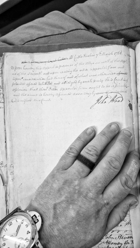
A Chancery Court judgment delivered on 7 March 1766 at Castle Rushen, affirming an appealed order following oral arguments from both appellant and respondent counsel. The court dismissed the appeal after reviewing the original order and hearing evidence from both parties.
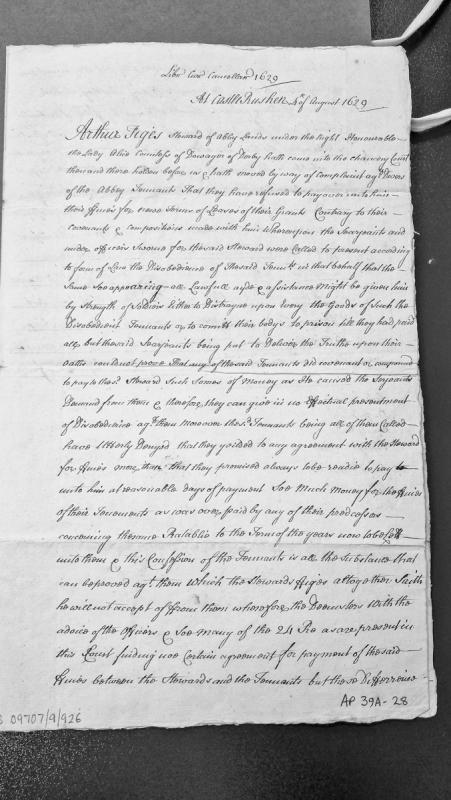
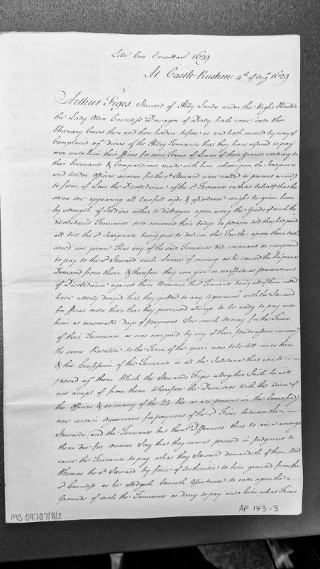
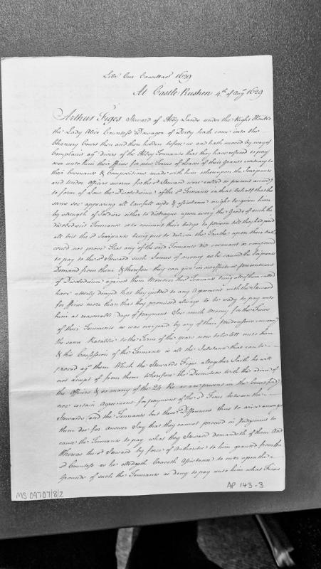
A Chancery Court record from Castle Rushen documenting a complaint by Arthur Figes, Steward of Abbey Lands under the Countess of Derby, against tenants who refused to pay fines for lease terms. The court examined whether the tenants had covenanted to pay specific sums, ultimately finding no certain agreement existed between the steward and tenants.
Record of a Chancery Court hearing at Castle Rushen where Arthur Figes, Steward of Abbey Lands under the Countess of Derby, brought complaint against abbey tenants for refusing to pay fines for new lease terms. The Deemsters and court officers find no certain agreement for payment and decline to compel the tenants to pay the demanded fines.
A Chancery Court record from Castle Rushen documenting a complaint by Arthur Jiges, Steward of Abbey Lands under the Countess Dowager of Derby, against abbey tenants who refused to pay fines for new lease terms. The court found no binding agreement between the steward and tenants regarding payment amounts, ruling the tenants need only pay fines consistent with historical precedent.
A worked stone found at Chapel Hill, close to the chapel and enclosure bank at the west end of the hilltop.
The stone was used for grinding, smoothing or sharpening, and is bar-shaped: rectangular in outline and cross-section. It measures 150 x 45 x 20mm.
The natural stone in the immediate vicinity is limestone.
The stone is in the Manx National Heritage collections, accession no. 1954-1635.