A group of four, undated, standing stones, which stand on a slight natural spur in an undulating pasture field. They are prominently sited when seen from lower ground and their elevated position affords wide views in most directions. Two of the stones are undoubtedly standing in their original setting but the other two are probably displaced as both are recumbent. There is a stony mound contained by the two standing stones in which both of the recumbent stones are embedded, but stone also spreads out to the west and it seems likely that some of the mound at least, has resulted from field clearance. The two upright stones are 4.0 metres apart with the largest being 1.2 metres high, 1.5 metres broad and 0.8 metres thick, at the northeast. The smaller upright stone is a slab 1.0 metre high, 1.7 metres broad and 0.4 metres thick on the southeast. The smallest is on the southwest, whilst the fourth is due east. The distance between the two recumbent stones is 2.7 metres. None of the stones is cup-marked. They have many of the characteristics of the Scottish-Northumbrian Four-Posters and the visible remains suggest that it could be related to this type of monument.
The two standing stones and two recumbent stones at Clagh Ard (PRN 0191.00) may represent the remains of Four Post Stone Circle, with a burial cist of Bronze Age date within the stone setting.
This is the largest cross slab to have been found on the Isle of Man, on account of which it is sometimes named the Clagh Ard ('tall stone'). It stands 3.5m high. It was found at Ballaqueeney, and originally stood towards the northerly edge of the known extent of the burial ground surrounding the chapel (IOMHER 0024.00). It was for a while used as a door lintel in a farm building, as a result of which it is now badly worn.
Both faces were carved, bearing designs consisting of a shafted cross set in a circle. At the foot of one face the remains of ring-chain pattern have been recorded on the shaft, with twist-and-ring in the panel to the left and tendril pattern to the right. The other face is even more badly worn, but the head has yielded traces of interlace, and the shaft seems to have had plait-of-five, with twist-and-ring to the left, and plait-of-four to the right.
The 'Crosh Ballaqueeney' or 'Clagh Ard' is the largest cross-slab on the island, standing at Four Roads Port St Mary. It measures 3.35 metres high, by 0.66 metres wide and 0.17 metres thick. It formerly stood in the burial ground of Ballaqueeney keeill, undoubtedly above a Norse Christian grave.
A low mound surmounted by the corner of a field wall which extends to the west and to the north. In the angle formed by this wall is a fragment of a mound 5.0 metres long. At the outer part of the corner is a mis-shapen mound cut by a ditch in the east and mutilated in the south. It averages 6.0 metres long and is 0.3 metres high. There is no trace of stones. It is probably a barrow but it is at the junction of 3 parish boundaries and may be a boundary mound.
The site of a mound which is said to be a barrow or burial mound, though it has not been explored by archaeologists. It is located in an area which was an orchard south of Claghbane house on the 1870 1:2500 scale Ordnance Survey map.
The reported site of a prehistoric stone circle and cairns in an area where prehistoric flints and a hammerstone (PRN 0510.00) were found. William Cubbon noted the stone circle on an annotated map, but no further evidence has been recorded in the HER.
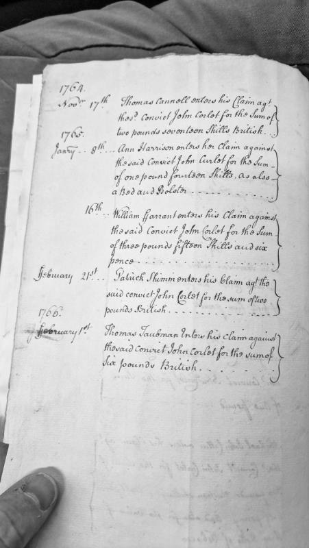
A register of financial claims entered against the convict John Corlet by various creditors between November 1764 and February 1766. The document records claims from five individuals totaling approximately £15, including both monetary sums and goods (a bed and bolster).
Letter from James Clarke to Henry Hobhouse (Under-Secretary of State) reporting the sudden death of Norris Moore, first Deemster of the Isle of Man, and noting the opportunity for judicial and administrative reform. Clarke emphasises Moore's legal ability, attributes his death to alcohol abuse, and identifies regulation of Deemsters' Courts and land administration as key issues for the island's governance.
Letter from James Clarke to Henry Hobhouse (Under-Secretary of State) reporting the sudden death of Norris Moore, first Deemster of the Isle of Man, and noting the need for enquiry into the regulation of Deemsters' Courts and administration of Manx lands. Provides insight into post-Revestment judicial administration and governance challenges on the Island.
The site of a Bronze Age cremation burial where a layer or platform of burnt stones, soil and ashes were found under a flat stone, in the late 19th century.
A group of three cairns or mounds east of the farm house, about 20 metres apart, now gone. They were located at the following locations; A - SC44118066; B - SC44018068; C - SC43988061.
A was ditchless grass-covered bowl barrow with a diameter of 16.0 metres and height to the north of 0.9 metres.
A cist is orientated northeast to southwest and measures internally 1.8 metres by 1.1 metres, and is lined with stone slabs up to 0.8 metres high. It is set on an irregular gorse covered mound with an average diameter of 8.0 metres and height of 0.3 metres. It appears to be a ditchless bowl barrow. In the south and pointing towards the cist with its north edge in line with the south ends of the east and west stones is an erect stone 1.0 metre high, 0.8 metres wide and 0.1 metres thick.
The site of a Watch and Ward beacon has been identified as the hill rising to a point at NGR SC 43297938. The Hill for the Day Watch for Lonan parish was at Sir William's Hill as mentioned in a document (Castle Rushen Papers) dated 1627. Cubbon stated that this hill was on Clay Head (shown at SC 428806 on the 1957 1:10560 scale Ordnance Survey map). There were two Ports for the Night Watch, one at Laxey (SC 4483) and the other at 'Gob Stoell', just south of Garwick, (Gob ny Stowell at SC 438813 on the 1957 1:10560 scale Ordnance Survey map). The majority of the Watch and Ward posts may well have been maintained on the same sites since the Middle Ages.
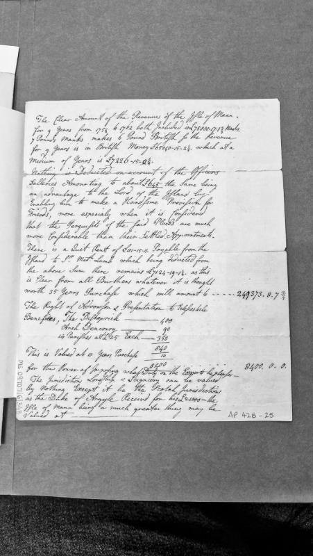
A revenue abstract detailing the clear revenues of the Isle of Mann for the nine-year period 1754-1762, calculated in both Manx and British currency. The document includes deductions for officer salaries and quit rents, provides valuations of ecclesiastical benefices and other rights, and appears to be an assessment or valuation document for the lordship.
A Neolithic round-based food jar belonging to the Ronaldsway culture was found here during ploughing, and donated to the Manx Museum in 1955 to 1956. The jar is thought to have been associated with a burial.
Earthwork. This large earthen bank and ditch crosses a ridge between two valleys. It survives as an earthwork features for around 300m, but a cropmark suggests that it may have extended for a further 300m as far as the bottom of the Lherghyrhenny valley to the south. The bank rises to a maximum height of over 2m near the top of the ridge, and a 3-4m wide ditch on the uphill side appears to have provided the necessary material. The bank peters out to the north close to the Tholt y Will stream, and the quarry ditch here has been eroded downwards by surface water run-off. To the south of the apex of the ridge the bank and ditch have been damaged by the construction of a sheepfold, and further south the physical remains of the earthworks have been ploughed down within fields belonging to a nearby farm, which is now abandoned.
The sheer size of the bank and ditch where best preserved has given rise to comparison with Iron Age defences, though their topographical location militates against this. Their most practical use would seem to be as a barrier against animals - grazing stock or perhaps wild deer - and thus it is tempting to see the earthwork as an unusually large example of the 'mountain hedge' which from at least medieval times separated common land from farm land and prevented animals pastured on the uplands during the summer from trampling crops.